
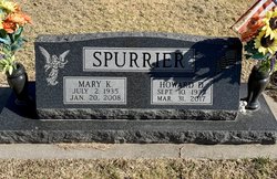
Mary Katherine Russell Spurrier
| Birth | : | 2 Jul 1935 Paola, Miami County, Kansas, USA |
| Death | : | 20 Jan 2008 Iola, Allen County, Kansas, USA |
| Burial | : | Christ Church Cemetery, Redding, Fairfield County, USA |
| Coordinate | : | 41.3136444, -73.3509903 |
| Description | : | ********************* Chanute Tribune - Chanute, KS - January 22, 2008 Mary Katherine Spurrier, 72, Chanute, Kansas, died Sunday, January 20, 2008, at Tara Gardens, Iola, Kansas. She was born July 2, 1935, in Paola, Kansas, to Kenneth L. and LaVeta (Bates) Russell. She graduated from Paola High School in 1953. She married William G. Jenkins in 1953. They later divorced. She married Howard D. Spurrier on Jan. 1, 1978. He survives. She worked in advertising sales. Survivors include her children and their spouses, Kenneth L. and Joyce Jenkins, Olathe, KS, Douglas M. Jenkins, Chanute, KS, Marlon D. and Michelle Spurrier, Chanute, KS,... Read More |
frequently asked questions (FAQ):
-
Where is Mary Katherine Russell Spurrier's memorial?
Mary Katherine Russell Spurrier's memorial is located at: Christ Church Cemetery, Redding, Fairfield County, USA.
-
When did Mary Katherine Russell Spurrier death?
Mary Katherine Russell Spurrier death on 20 Jan 2008 in Iola, Allen County, Kansas, USA
-
Where are the coordinates of the Mary Katherine Russell Spurrier's memorial?
Latitude: 41.3136444
Longitude: -73.3509903
Family Members:

Flowers:


Nearby Cemetories:
1. Christ Church Cemetery
Redding, Fairfield County, USA
Coordinate: 41.3136444, -73.3509903
2. Redding Ridge Cemetery
Redding, Fairfield County, USA
Coordinate: 41.3088989, -73.3475037
3. Hopewell Cemetery
Redding, Fairfield County, USA
Coordinate: 41.3315000, -73.3390000
4. First Church of Christ Congregational Mem Garden
West Redding, Fairfield County, USA
Coordinate: 41.3047400, -73.3787580
5. Sanford Cemetery
Redding, Fairfield County, USA
Coordinate: 41.3013260, -73.3226520
6. Redding Center Cemetery
Redding, Fairfield County, USA
Coordinate: 41.3035545, -73.3822784
7. Great Pasture Road Cemetery
Redding, Fairfield County, USA
Coordinate: 41.2990000, -73.3901000
8. Den Cemetery
Easton, Fairfield County, USA
Coordinate: 41.2810300, -73.3401300
9. Isaac Hamilton Cemetery
Redding, Fairfield County, USA
Coordinate: 41.3297424, -73.3904114
10. Lyon Cemetery
Easton, Fairfield County, USA
Coordinate: 41.2919000, -73.3146000
11. Putnam Memorial State Park
Redding, Fairfield County, USA
Coordinate: 41.3421478, -73.3833084
12. Hull Cemetery
Redding, Fairfield County, USA
Coordinate: 41.2971992, -73.3972015
13. Bennett Cemetery
Easton, Fairfield County, USA
Coordinate: 41.3015214, -73.2870569
14. Wolfpit Cemetery
Bethel, Fairfield County, USA
Coordinate: 41.3591000, -73.3789000
15. Umpawaug Cemetery
Redding, Fairfield County, USA
Coordinate: 41.2949982, -73.4197006
16. Morgan Cemetery
Newtown, Fairfield County, USA
Coordinate: 41.3671989, -73.3308029
17. Huntingtown Cemetery
Newtown, Fairfield County, USA
Coordinate: 41.3499985, -73.2932968
18. Godfrey Cemetery
Weston, Fairfield County, USA
Coordinate: 41.2596300, -73.3738980
19. Union Cemetery
Easton, Fairfield County, USA
Coordinate: 41.2728004, -73.2972031
20. Benedictine Grange Cemetery
Redding, Fairfield County, USA
Coordinate: 41.2740370, -73.4065730
21. Flat Swamp Cemetery #01
Newtown, Fairfield County, USA
Coordinate: 41.3745689, -73.3469772
22. Flat Swamp Cemetery #2
Newtown, Fairfield County, USA
Coordinate: 41.3752556, -73.3464661
23. Stepney Cemetery
Monroe, Fairfield County, USA
Coordinate: 41.3224983, -73.2632980
24. Saint Marys Cemetery
Bethel, Fairfield County, USA
Coordinate: 41.3591995, -73.4167023