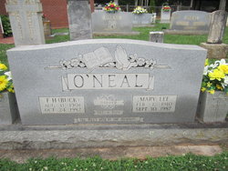
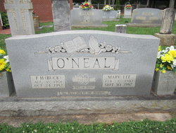
Mary Lee Patterson O'Neal
| Birth | : | 1 Feb 1910 Surry County, North Carolina, USA |
| Death | : | 30 Sep 1987 Winston-Salem, Forsyth County, North Carolina, USA |
| Burial | : | Level Cross United Methodist Church Cemetery, Level Cross, Surry County, USA |
| Coordinate | : | 36.3450000, -80.6288610 |
| Description | : | She was always referred to as "Mary Lee" by her family. |
frequently asked questions (FAQ):
-
Where is Mary Lee Patterson O'Neal's memorial?
Mary Lee Patterson O'Neal's memorial is located at: Level Cross United Methodist Church Cemetery, Level Cross, Surry County, USA.
-
When did Mary Lee Patterson O'Neal death?
Mary Lee Patterson O'Neal death on 30 Sep 1987 in Winston-Salem, Forsyth County, North Carolina, USA
-
Where are the coordinates of the Mary Lee Patterson O'Neal's memorial?
Latitude: 36.3450000
Longitude: -80.6288610
Family Members:
Parent
Spouse
Siblings
Children
Flowers:
Nearby Cemetories:
1. Level Cross United Methodist Church Cemetery
Level Cross, Surry County, USA
Coordinate: 36.3450000, -80.6288610
2. Hardy Family Cemetery
Level Cross, Surry County, USA
Coordinate: 36.3456800, -80.6238300
3. Anchored In Jesus Baptist Church Cemetery
Copeland, Surry County, USA
Coordinate: 36.3420110, -80.6418400
4. Jesus' Church Of Corinth Cemetery
Level Cross, Surry County, USA
Coordinate: 36.3514550, -80.6177870
5. Atkins O'Neal Family Cemetery
Mount Airy, Surry County, USA
Coordinate: 36.3305680, -80.6293220
6. Miller-Holyfield Cemetery
Dobson, Surry County, USA
Coordinate: 36.3314380, -80.6190140
7. Harbour Family Cemetery
Dobson, Surry County, USA
Coordinate: 36.3602530, -80.6352700
8. Wolff Family Cemetery
Ararat, Surry County, USA
Coordinate: 36.3584444, -80.6416389
9. Solid Rock Bible Believing Baptist Church Cemetery
Ararat, Surry County, USA
Coordinate: 36.3605003, -80.6411362
10. Wall Cemetery
Ararat, Surry County, USA
Coordinate: 36.3670560, -80.6150560
11. Whitaker Family Cemetery
Siloam, Surry County, USA
Coordinate: 36.3329167, -80.6019722
12. Copeland Baptist Church Cemetery
Copeland, Surry County, USA
Coordinate: 36.3255577, -80.6531677
13. Bowman Family Cemetery
Ararat, Surry County, USA
Coordinate: 36.3734436, -80.6265259
14. New Beginning Baptist Church Cemetery
Black Water, Surry County, USA
Coordinate: 36.3739930, -80.6229330
15. New Home Church of Christ Cemetery
Dobson, Surry County, USA
Coordinate: 36.3625800, -80.6583480
16. Buelin Cemetery
Ararat, Surry County, USA
Coordinate: 36.3735220, -80.6144520
17. Lewis Jones Key Family Cemetery
Dobson, Surry County, USA
Coordinate: 36.3762400, -80.6342900
18. Dennis Family Cemetery
Siloam, Surry County, USA
Coordinate: 36.3531700, -80.5906700
19. Rock Hill Baptist Church Cemetery
Black Water, Surry County, USA
Coordinate: 36.3756104, -80.6174698
20. Pine Hill Cemetery
Pine Hill, Surry County, USA
Coordinate: 36.3495560, -80.5889969
21. Double Creek Church of Christ Cemetery
Copeland, Surry County, USA
Coordinate: 36.3128640, -80.6437320
22. William Stanley Family Cemetery
Stony Knoll, Surry County, USA
Coordinate: 36.3169920, -80.6579960
23. Liberty Baptist Church Cemetery
Dobson, Surry County, USA
Coordinate: 36.3330345, -80.6722488
24. Union Primitive Baptist Church Cemetery
Black Water, Surry County, USA
Coordinate: 36.3821983, -80.6282425


