

Mary Linda Banks Winholtz
| Birth | : | 10 Feb 1940 Burwell, Garfield County, Nebraska, USA |
| Death | : | 2 Nov 2008 Kearney, Buffalo County, Nebraska, USA |
| Burial | : | Civic Memorial Cemetery, Sudbury, Greater Sudbury Municipality, Canada |
| Coordinate | : | 46.4995995, -80.9368515 |
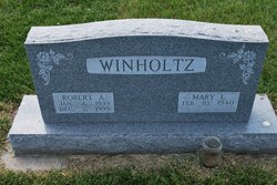
| Description | : | Daughter of John and Margaret (Hansen) Banks. Grew up in Grand Island, graduated from Grand Island High School in 1958; attended Kearney State Teachers College, received her teaching degree, later graduated from Kearney State College. Married: Jan. 21, 1961, to Robert Winholtz in Council Bluffs, Iowa. He died in 1999. Moved to the Axtell area ona farm; worked at the Bethphage day care in Axtell then worked with her daughter at Cindy Jacobs Limited, retired in 2002; moved to Kearney in 2000. Activities: member of Kearney Evangelical Free Church and the Joy Fellowship at the church; was active at the Kearney Senior Hospitality Center,... Read More |
frequently asked questions (FAQ):
-
Where is Mary Linda Banks Winholtz's memorial?
Mary Linda Banks Winholtz's memorial is located at: Civic Memorial Cemetery, Sudbury, Greater Sudbury Municipality, Canada.
-
When did Mary Linda Banks Winholtz death?
Mary Linda Banks Winholtz death on 2 Nov 2008 in Kearney, Buffalo County, Nebraska, USA
-
Where are the coordinates of the Mary Linda Banks Winholtz's memorial?
Latitude: 46.4995995
Longitude: -80.9368515
Family Members:
Parent

Spouse
Siblings
Flowers:


Nearby Cemetories:
1. Civic Memorial Cemetery
Sudbury, Greater Sudbury Municipality, Canada
Coordinate: 46.4995995, -80.9368515
2. LaSalle Roman Catholic Cemetery
Sudbury, Greater Sudbury Municipality, Canada
Coordinate: 46.5226600, -80.9773200
3. Sudbury Anglican Cemetery
Sudbury, Greater Sudbury Municipality, Canada
Coordinate: 46.4843600, -81.0075800
4. Eyre Cemetery
Sudbury, Greater Sudbury Municipality, Canada
Coordinate: 46.4839190, -81.0080430
5. Park Lawn Cemetery
Sudbury, Greater Sudbury Municipality, Canada
Coordinate: 46.4842010, -81.0127730
6. Saint John's Cemetery
Garson, Greater Sudbury Municipality, Canada
Coordinate: 46.5513581, -80.8613157
7. McFarlane Cemetery
Sudbury, Greater Sudbury Municipality, Canada
Coordinate: 46.4358620, -80.9913230
8. Long Lake Finnish Cemetery
Sudbury, Sudbury District, Canada
Coordinate: 46.4218490, -81.0052630
9. Good Shepherd Cemetery
Garson, Greater Sudbury Municipality, Canada
Coordinate: 46.5722850, -80.8472730
10. Ruff Pioneer Cemetery
Garson, Greater Sudbury Municipality, Canada
Coordinate: 46.5586900, -80.8132800
11. Wahnapitae Protestant Cemetery
Sudbury, Sudbury District, Canada
Coordinate: 46.4905280, -80.7858910
12. Wahnapitae Catholic Cemetery
Sudbury, Sudbury District, Canada
Coordinate: 46.4892760, -80.7840900
13. Blezard Valley Cemetery
Blezard Valley, Greater Sudbury Municipality, Canada
Coordinate: 46.6094760, -81.0542630
14. Saint Stanislaus Roman Catholic Cemetery New
Lively, Greater Sudbury Municipality, Canada
Coordinate: 46.4316700, -81.1162900
15. Saint Jacques Roman Catholic Cemetery
Hanmer, Greater Sudbury Municipality, Canada
Coordinate: 46.6520700, -80.9422600
16. Waters Cemetery
Lively, Greater Sudbury Municipality, Canada
Coordinate: 46.4236500, -81.1359200
17. Valley East Cemetery
Valley East, Greater Sudbury Municipality, Canada
Coordinate: 46.6675800, -80.9518900
18. St. Joseph's Catholic Cemetery
Chelmsford, Greater Sudbury Municipality, Canada
Coordinate: 46.5855050, -81.1820650
19. Atikameksheng Cemetery
Naughton, Greater Sudbury Municipality, Canada
Coordinate: 46.4014470, -81.1790660
20. Capreol Cemetery
Capreol, Greater Sudbury Municipality, Canada
Coordinate: 46.6962130, -80.9126210
21. Elbow Ridge Cemetery
Estaire, Sudbury District, Canada
Coordinate: 46.3236700, -80.7989760
22. Chelmsford Protestant Cemetery
Chelmsford, Greater Sudbury Municipality, Canada
Coordinate: 46.5687130, -81.2120780
23. Pinehill Cemetery
Markstay, Sudbury District, Canada
Coordinate: 46.4936700, -80.5532600
24. Burwash Industrial Prison Farm Graveyard
Burwash, Sudbury District, Canada
Coordinate: 46.2342590, -80.8510330