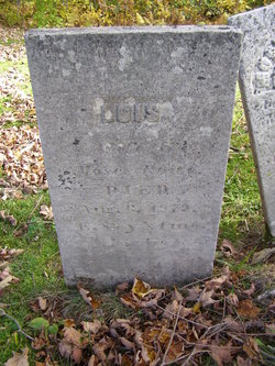
Mary Ordway Fellows Brown
| Birth | : | 25 Dec 1789 Bridgewater, Grafton County, New Hampshire, USA |
| Death | : | 25 Feb 1841 Bridgewater, Grafton County, New Hampshire, USA |
| Burial | : | Dalmanutha Cemetery, Guthrie Center, Guthrie County, USA |
| Coordinate | : | 41.5867004, -94.5543976 |
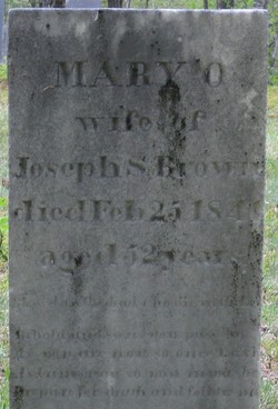
| Inscription | : | Mary O. | wife of | Joseph S. Brown | died Feb 25 1841 | aged 52 years. | Blessed are the dead who die in the Lord | Behold and see as you pass by | As you are now so once was I | As I am now so you must be | Prepare for deat |
| Description | : | To their union was born 4 children: Lois Brown, Jonathan Brown, Horatio Brown, and Theodore Brown. Joseph and his two children, Jonathan Brown and Horatio Brown, emigrated to Minnesota where they were victims of the Sioux Massacre in 1862. They lived far from any other settlers, on the road between New Ulm and Lake Shetek. They operated a stopping off place for travelers on the road. In 1862, the Dakota Indians, who lived on a nearby reservation, were frustrated with their situation for a variety of reasons. On August 18, 1862, they began an uprising against the whites living in... Read More |
frequently asked questions (FAQ):
-
Where is Mary Ordway Fellows Brown's memorial?
Mary Ordway Fellows Brown's memorial is located at: Dalmanutha Cemetery, Guthrie Center, Guthrie County, USA.
-
When did Mary Ordway Fellows Brown death?
Mary Ordway Fellows Brown death on 25 Feb 1841 in Bridgewater, Grafton County, New Hampshire, USA
-
Where are the coordinates of the Mary Ordway Fellows Brown's memorial?
Latitude: 41.5867004
Longitude: -94.5543976
Family Members:
Parent
Spouse
Siblings
Children
Flowers:
Nearby Cemetories:
1. Maplewood Cemetery
Guthrie Center, Guthrie County, USA
Coordinate: 41.6389020, -94.5224090
2. Spring Valley Cemetery
Casey, Guthrie County, USA
Coordinate: 41.5220000, -94.5046000
3. Bear Grove Cemetery
Guthrie Center, Guthrie County, USA
Coordinate: 41.6455994, -94.6194000
4. Stanfield Cemetery
Casey, Guthrie County, USA
Coordinate: 41.5124870, -94.5016370
5. Saint Joseph's Cemetery
Walnut Township, Adair County, USA
Coordinate: 41.4986000, -94.5096970
6. Oakwood Cemetery
Walnut Township, Adair County, USA
Coordinate: 41.4977989, -94.5074997
7. Monteith Cemetery
Monteith, Guthrie County, USA
Coordinate: 41.6307850, -94.4348130
8. Immanuel Lutheran Cemetery
Adair, Guthrie County, USA
Coordinate: 41.5104000, -94.6431700
9. Union Cemetery
Guthrie Center, Guthrie County, USA
Coordinate: 41.6800680, -94.4917180
10. Valley Township Cemetery
Guthrie Center, Guthrie County, USA
Coordinate: 41.6818390, -94.4879790
11. Saint Johns Cemetery
Brayton, Audubon County, USA
Coordinate: 41.5625000, -94.7019000
12. Saint Johns Lutheran Cemetery
Audubon, Audubon County, USA
Coordinate: 41.5625000, -94.7019000
13. Glendon Cemetery
Glendon, Guthrie County, USA
Coordinate: 41.5985240, -94.4018810
14. Sunnyhill Cemetery
Adair, Adair County, USA
Coordinate: 41.4907990, -94.6402969
15. Saint John's Catholic Cemetery
Adair, Adair County, USA
Coordinate: 41.4902992, -94.6425018
16. Abandoned Timber Cemetery
Canby, Adair County, USA
Coordinate: 41.4833208, -94.4808020
17. Rosehill Cemetery
Menlo, Guthrie County, USA
Coordinate: 41.5335999, -94.4052963
18. Resurrection Cemetery
Guthrie Center, Guthrie County, USA
Coordinate: 41.6870003, -94.4550018
19. Pleasant Hill Cemetery
Audubon County, USA
Coordinate: 41.5806007, -94.7210999
20. Menlo Cemetery
Menlo, Guthrie County, USA
Coordinate: 41.5321999, -94.4028015
21. North Branch Cemetery
Guthrie County, USA
Coordinate: 41.6460000, -94.7222000
22. Pleasant Hill Cemetery
North Branch, Guthrie County, USA
Coordinate: 41.6603012, -94.7236023
23. Seeley Township Cemetery
Guthrie County, USA
Coordinate: 41.7318993, -94.6147003
24. Victory Union Cemetery
Guthrie Center, Guthrie County, USA
Coordinate: 41.7282982, -94.4738998

