
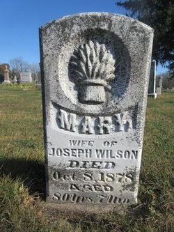

Mary “Polly” Freel Wilson
| Birth | : | 8 Mar 1798 Cecil County, Maryland, USA |
| Death | : | 3 Aug 1878 Hartford, Warren County, Iowa, USA |
| Burial | : | Shelburne Cemetery, Shelburne, Dufferin County, Canada |
| Coordinate | : | 44.0927010, -80.2090378 |
| Description | : | wf of Joseph Wilson. Her headstone reading "Mary, wife of Joseph" Daughter of James Freel & Jean Wood. She was the 8th born of 14 children. Mary Freel married 17 Jan 1818 in Franklin Co., Indiana to Joseph Wilson. Sometime after their marriage Mary & Joseph moved to Lafayette, Tippecanoe, Indiana with other members of the family, arriving there in 1827. In 1854 Mary & her family left Indiana and moved to Belmont Twp. Warren Co., Iowa, receiving a land grant for 75 acres. The trip to Iowa was without husband Joseph who died March 1845 in Lafayette, Indiana. ... Read More |
frequently asked questions (FAQ):
-
Where is Mary “Polly” Freel Wilson's memorial?
Mary “Polly” Freel Wilson's memorial is located at: Shelburne Cemetery, Shelburne, Dufferin County, Canada.
-
When did Mary “Polly” Freel Wilson death?
Mary “Polly” Freel Wilson death on 3 Aug 1878 in Hartford, Warren County, Iowa, USA
-
Where are the coordinates of the Mary “Polly” Freel Wilson's memorial?
Latitude: 44.0927010
Longitude: -80.2090378
Family Members:
Parent
Spouse
Siblings

Children
Flowers:


Nearby Cemetories:
1. Shelburne Cemetery
Shelburne, Dufferin County, Canada
Coordinate: 44.0927010, -80.2090378
2. Melancthon United Church Cemetery
Melancthon, Dufferin County, Canada
Coordinate: 44.1026710, -80.2557530
3. Saint Paul's Anglican Cemetery
Melancthon, Dufferin County, Canada
Coordinate: 44.1028300, -80.2559300
4. Spring Valley Cemetery
Horning's Mills, Dufferin County, Canada
Coordinate: 44.1466460, -80.2026950
5. Hornings Mills Cemetery
Horning's Mills, Dufferin County, Canada
Coordinate: 44.1574010, -80.2063900
6. Whitfield United Church Cemetery
Whitfield, Dufferin County, Canada
Coordinate: 44.1457200, -80.1355400
7. Christ Church Anglican Whitfield Cemetery
Whitfield, Dufferin County, Canada
Coordinate: 44.1484800, -80.1363400
8. Granger Cemetery
Granger, Dufferin County, Canada
Coordinate: 44.0608800, -80.0944500
9. Burns Cemetery
Mono, Dufferin County, Canada
Coordinate: 44.0313290, -80.0733000
10. Perm Methodist Cemetery
Perm, Dufferin County, Canada
Coordinate: 44.1618350, -80.0703890
11. Mulmur Pioneer Cemetery
Mulmur, Dufferin County, Canada
Coordinate: 44.1204900, -80.0423800
12. Primrose Presbyterian Cemetery
Mulmur, Dufferin County, Canada
Coordinate: 44.1893219, -80.1026086
13. Honeywood Cemetery
Honeywood, Dufferin County, Canada
Coordinate: 44.2249100, -80.1870100
14. Laurel Cemetery
Laurel, Dufferin County, Canada
Coordinate: 43.9579300, -80.2106700
15. Relessey Cemetery
Relessey, Dufferin County, Canada
Coordinate: 44.0479400, -80.0269170
16. Mansfield Presbyterian Cemetery
Mansfield, Dufferin County, Canada
Coordinate: 44.1644100, -80.0378170
17. Saint Luke's Anglican Cemetery
Mulmur, Dufferin County, Canada
Coordinate: 44.1238800, -80.0103800
18. Zion Wesleyan Methodist Cemetery
Mono, Dufferin County, Canada
Coordinate: 43.9548170, -80.1244380
19. Maple Grove Cemetery
Dundalk, Grey County, Canada
Coordinate: 44.1599000, -80.4026800
20. Rosemont United Church Cemetery
Rosemont, Simcoe County, Canada
Coordinate: 44.1146070, -79.9869440
21. Mono College Presbyterian Cemetery
Orangeville, Dufferin County, Canada
Coordinate: 43.9494200, -80.1049200
22. Rosemont Pioneer Cemetery
Rosemont, Simcoe County, Canada
Coordinate: 44.1258500, -79.9839100
23. McDougall Cemetery
Grand Valley, Dufferin County, Canada
Coordinate: 43.9452210, -80.3261600
24. Wesley Wesleyan Methodist Cemetery
Mono, Dufferin County, Canada
Coordinate: 44.0543854, -79.9774115