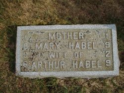
Mary Sand Habel
| Birth | : | 22 Nov 1896 Phillips, Price County, Wisconsin, USA |
| Death | : | 29 Jan 1929 Teton County, Montana, USA |
| Burial | : | Seattle Historic Sephardic Cemetery, Seattle, King County, USA |
| Coordinate | : | 47.7118900, -122.3399900 |
| Description | : | First Victim of Cold Death of Mary A. Habel, 32, in child birth Monday night, is the first reported casualty of Montana's recent period of extreme cold. Arthur Habel, the husband, summoned a doctor to their ranch home 10 miles northeast of Dutton, about 6 o'clock Monday night. With the roads out of sight under drifted snow and the temperature ranging 30 below, the medical men were unable to make the trip. They went out the following morning with a nurse, to find Mrs. Habel dead but the child, a girl, living. Havre Daily News Promoter (MT), 30 Jan 1929 |
frequently asked questions (FAQ):
-
Where is Mary Sand Habel's memorial?
Mary Sand Habel's memorial is located at: Seattle Historic Sephardic Cemetery, Seattle, King County, USA.
-
When did Mary Sand Habel death?
Mary Sand Habel death on 29 Jan 1929 in Teton County, Montana, USA
-
Where are the coordinates of the Mary Sand Habel's memorial?
Latitude: 47.7118900
Longitude: -122.3399900
Family Members:
Parent
Spouse
Siblings
Children
Flowers:
Nearby Cemetories:
1. Seattle Historic Sephardic Cemetery
Seattle, King County, USA
Coordinate: 47.7118900, -122.3399900
2. New Bikur Cholim Cemetery
Seattle, King County, USA
Coordinate: 47.7128800, -122.3402700
3. Orthodox Brotherly Cemetery of Saint Nicholas
Seattle, King County, USA
Coordinate: 47.7122002, -122.3377991
4. Evergreen-Washelli Memorial Park
Seattle, King County, USA
Coordinate: 47.7104000, -122.3396400
5. Pacific Lutheran Cemetery
Seattle, King County, USA
Coordinate: 47.7120520, -122.3360360
6. Saint Dunstan's Episcopal Church Columbarium
Shoreline, King County, USA
Coordinate: 47.7344250, -122.3487390
7. Crown Hill Cemetery
Seattle, King County, USA
Coordinate: 47.6935997, -122.3685989
8. Phinney Ridge Lutheran Church Columbarium
Seattle, King County, USA
Coordinate: 47.6837900, -122.3549100
9. Machzikay Hadath Cemetery
Seattle, King County, USA
Coordinate: 47.7517014, -122.3424988
10. Seattle Sephardic Brotherhood Cemetery
Shoreline, King County, USA
Coordinate: 47.7518000, -122.3437000
11. Herzl Memorial Park
Shoreline, King County, USA
Coordinate: 47.7507210, -122.3550034
12. Acacia Memorial Park and Funeral Home
Lake Forest Park, King County, USA
Coordinate: 47.7392006, -122.2928009
13. Calvary Cemetery
Seattle, King County, USA
Coordinate: 47.6666985, -122.2917023
14. Holyrood Cemetery
Shoreline, King County, USA
Coordinate: 47.7745200, -122.3274600
15. Fort Lawton Cemetery
Seattle, King County, USA
Coordinate: 47.6601181, -122.4055252
16. Hills of Eternity Reform Cemetery
Seattle, King County, USA
Coordinate: 47.6441994, -122.3643036
17. Queen Anne Columbarium
Seattle, King County, USA
Coordinate: 47.6432000, -122.3644000
18. Mount Pleasant Cemetery
Seattle, King County, USA
Coordinate: 47.6432800, -122.3662643
19. Restlawn Memorial Gardens
Edmonds, Snohomish County, USA
Coordinate: 47.7832900, -122.3722400
20. Congregation Beth Shalom Cemetery
Brier, Snohomish County, USA
Coordinate: 47.7782000, -122.2851000
21. Grand Army of the Republic Cemetery
Seattle, King County, USA
Coordinate: 47.6363602, -122.3162994
22. Abbey View Memorial Park
Brier, Snohomish County, USA
Coordinate: 47.7797012, -122.2806015
23. Lake View Cemetery
Seattle, King County, USA
Coordinate: 47.6342010, -122.3143997
24. Saint Mark's Episcopal Cathedral Columbarium
Seattle, King County, USA
Coordinate: 47.6319000, -122.3208000

