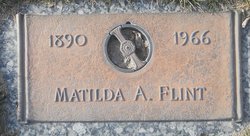
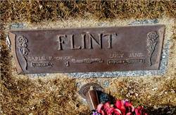
Matilda A. “Tillie” Miller Flint
| Birth | : | 2 Aug 1890 Bassett, Rock County, Nebraska, USA |
| Death | : | 7 Jul 1966 North Platte, Lincoln County, Nebraska, USA |
| Burial | : | Oak Grove Cemetery, Taylor County, USA |
| Coordinate | : | 39.4143982, -79.9238968 |
frequently asked questions (FAQ):
-
Where is Matilda A. “Tillie” Miller Flint's memorial?
Matilda A. “Tillie” Miller Flint's memorial is located at: Oak Grove Cemetery, Taylor County, USA.
-
When did Matilda A. “Tillie” Miller Flint death?
Matilda A. “Tillie” Miller Flint death on 7 Jul 1966 in North Platte, Lincoln County, Nebraska, USA
-
Where are the coordinates of the Matilda A. “Tillie” Miller Flint's memorial?
Latitude: 39.4143982
Longitude: -79.9238968
Family Members:
Parent
Spouse
Siblings
Children
Flowers:
Nearby Cemetories:
1. Oak Grove Cemetery
Taylor County, USA
Coordinate: 39.4143982, -79.9238968
2. Ford Cemetery
Taylor County, USA
Coordinate: 39.4099998, -79.9180984
3. Matthew Cemetery
Taylor County, USA
Coordinate: 39.4356003, -79.9291992
4. Slab Camp Cemetery
Taylor County, USA
Coordinate: 39.4439210, -79.9213680
5. Boyce Cemetery
Grafton, Taylor County, USA
Coordinate: 39.3918991, -79.9552994
6. Bock Cemetery
Preston County, USA
Coordinate: 39.4251750, -79.8777740
7. Rogers Cemetery
Grafton, Taylor County, USA
Coordinate: 39.4071999, -79.9721985
8. McConkey Cemetery
Taylor County, USA
Coordinate: 39.4103012, -79.9730988
9. Galliher Family Cemetery
Hebron, Marion County, USA
Coordinate: 39.4510500, -79.9510330
10. Haymond Cemetery
Grafton, Taylor County, USA
Coordinate: 39.3807240, -79.9579350
11. Moran Cemetery
Taylor County, USA
Coordinate: 39.4081001, -79.9824982
12. Union Cemetery
Independence, Preston County, USA
Coordinate: 39.4118996, -79.8625031
13. Waters Cemetery
Independence, Preston County, USA
Coordinate: 39.4224200, -79.8585260
14. Amnon Cemetery
Taylor County, USA
Coordinate: 39.4007988, -79.9878006
15. Hunt Cemetery
Preston County, USA
Coordinate: 39.3719440, -79.8750000
16. Saint John's Catholic Cemetery
Newburg, Preston County, USA
Coordinate: 39.3860790, -79.8575630
17. Gladesville Cemetery
Gladesville, Preston County, USA
Coordinate: 39.4649500, -79.8840000
18. Pride Cemetery
Fairmont, Marion County, USA
Coordinate: 39.4371986, -79.9961014
19. Lake Cemetery
Marion County, USA
Coordinate: 39.4241982, -80.0036011
20. Brown Cemetery
Gladesville, Preston County, USA
Coordinate: 39.4758330, -79.9080550
21. Union Cemetery
Newburg, Preston County, USA
Coordinate: 39.3862200, -79.8503200
22. Current Cemetery
Taylor County, USA
Coordinate: 39.3642006, -79.9753036
23. Halleck Cemetery
Monongalia County, USA
Coordinate: 39.4771900, -79.9414700
24. Sapp-Weaver Cemetery
Gladesville, Preston County, USA
Coordinate: 39.4509400, -79.8523300

