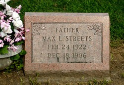
Max L. Streets
| Birth | : | 24 Feb 1922 Maquoketa, Jackson County, Iowa, USA |
| Death | : | 18 Dec 1986 Maquoketa, Jackson County, Iowa, USA |
| Burial | : | Saint Bernard's Cemetery, Enfield, Hartford County, USA |
| Coordinate | : | 41.9930992, -72.5274963 |
| Description | : | Max L Streets, 64, of 905 Kathy Drive, Maquoketa, died Thursday, December 18, 1986, Jackson County Public Hospital. He was born February 24, 1922, Maquoketa, to Vern & Rosetta Isbell Streets. He married Leola Mae Lambert, August 29, 1943, Dubuque. She died July 14, 1959. He married Hazel Manning McPherson June 24, 1960, Dubuque. He was a long-time businessman, farmer, owner& operator of Main Street Inn, Maquoketa. He was a member of Eagles Club & Knights of Pythias, Maquoketa. Survivors include his wife, Hazel, 2 daughters, Mrs William (Nancy Jo) Baker, & Mrs Carl (Barbara) Hardison, both of... Read More |
frequently asked questions (FAQ):
-
Where is Max L. Streets's memorial?
Max L. Streets's memorial is located at: Saint Bernard's Cemetery, Enfield, Hartford County, USA.
-
When did Max L. Streets death?
Max L. Streets death on 18 Dec 1986 in Maquoketa, Jackson County, Iowa, USA
-
Where are the coordinates of the Max L. Streets's memorial?
Latitude: 41.9930992
Longitude: -72.5274963
Family Members:
Spouse
Flowers:
Nearby Cemetories:
1. Saint Bernard's Cemetery
Enfield, Hartford County, USA
Coordinate: 41.9930992, -72.5274963
2. Islamic Center Cemetery
Enfield, Hartford County, USA
Coordinate: 41.9968109, -72.5389862
3. Old Hazardville Cemetery
Hazardville, Hartford County, USA
Coordinate: 41.9867897, -72.5409393
4. New Hazardville Cemetery
Hazardville, Hartford County, USA
Coordinate: 41.9883804, -72.5450592
5. Shaker Cemetery
Enfield, Hartford County, USA
Coordinate: 42.0141400, -72.5161600
6. Lindy Farms Cemetery
Enfield, Hartford County, USA
Coordinate: 41.9589427, -72.5195122
7. Saint Adalbert Cemetery
Enfield, Hartford County, USA
Coordinate: 42.0026207, -72.5878754
8. Holy Cross Cemetery
Enfield, Hartford County, USA
Coordinate: 42.0035362, -72.5912170
9. Enfield Street Cemetery
Enfield, Hartford County, USA
Coordinate: 41.9844017, -72.5916977
10. West Cemetery
Somers, Tolland County, USA
Coordinate: 41.9836006, -72.4606018
11. Billings Hill Cemetery
East Longmeadow, Hampden County, USA
Coordinate: 42.0433860, -72.5000000
12. Melrose Cemetery
East Windsor, Hartford County, USA
Coordinate: 41.9372711, -72.5246735
13. Thompsonville Cemetery
Enfield, Hartford County, USA
Coordinate: 42.0054893, -72.6010895
14. Old Saint Patricks Cemetery
Enfield, Hartford County, USA
Coordinate: 42.0052528, -72.6022186
15. North Cemetery
Somers, Tolland County, USA
Coordinate: 41.9953003, -72.4492035
16. Somers Congregational Church Memorial Garden
Somers, Tolland County, USA
Coordinate: 41.9857190, -72.4461100
17. Austin Cemetery
Suffield, Hartford County, USA
Coordinate: 42.0075333, -72.6083833
18. Center Cemetery
Somers, Tolland County, USA
Coordinate: 41.9890900, -72.4391937
19. New Saint Patricks Cemetery
Enfield, Hartford County, USA
Coordinate: 41.9558100, -72.6030700
20. Longmeadow Cemetery
Longmeadow, Hampden County, USA
Coordinate: 42.0495262, -72.5791397
21. Green Lawn Cemetery
East Longmeadow, Hampden County, USA
Coordinate: 42.0645561, -72.5079727
22. Sikes Cemetery
Suffield, Hartford County, USA
Coordinate: 42.0268010, -72.6153050
23. Baptist Village Cemetery
East Longmeadow, Hampden County, USA
Coordinate: 42.0559920, -72.4711310
24. Woodlawn Cemetery
Suffield, Hartford County, USA
Coordinate: 41.9771996, -72.6311035


