
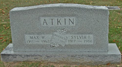
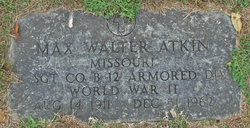
Max Walter Atkin
| Birth | : | 14 Aug 1911 Olean, Miller County, Missouri, USA |
| Death | : | 31 Dec 1962 Eldon, Miller County, Missouri, USA |
| Burial | : | Shrewsbury Center Cemetery, Shrewsbury, Rutland County, USA |
| Coordinate | : | 43.5060100, -72.8689700 |
| Description | : | Jefferson City Daily Capital News Thursday, January 3, 1963, Jefferson City, Missouri, United States Of America Funeral services will be at 2 pm today at the Olean Christian Church for Max Atkin, 51, who died at his home in Eldon Monday. The Rev. Alfred Scott will officiate with burial in Olean Cemetery. Mr. Atkin was born at Olean Aug. 14, 1911. He was married at Waynesville Oct. 3 1937 to Miss Sylvia Henry, who survives. Also surviving are his parents, Mr. and Mrs. W.A. Atkin. Obituary contributed by Deb Cooper |
frequently asked questions (FAQ):
-
Where is Max Walter Atkin's memorial?
Max Walter Atkin's memorial is located at: Shrewsbury Center Cemetery, Shrewsbury, Rutland County, USA.
-
When did Max Walter Atkin death?
Max Walter Atkin death on 31 Dec 1962 in Eldon, Miller County, Missouri, USA
-
Where are the coordinates of the Max Walter Atkin's memorial?
Latitude: 43.5060100
Longitude: -72.8689700
Family Members:
Parent
Spouse

Siblings
Flowers:


Nearby Cemetories:
1. Shrewsbury Center Cemetery
Shrewsbury, Rutland County, USA
Coordinate: 43.5060100, -72.8689700
2. Laurel Glen Cemetery
Cuttingsville, Rutland County, USA
Coordinate: 43.4852700, -72.8791800
3. Pelsue Cemetery
Wallingford, Rutland County, USA
Coordinate: 43.4765000, -72.8762700
4. Northam Cemetery
North Shrewsbury, Rutland County, USA
Coordinate: 43.5275002, -72.8313980
5. Hawkins Cemetery
Wallingford, Rutland County, USA
Coordinate: 43.4662830, -72.9112670
6. Packer Cemetery
Mount Holly, Rutland County, USA
Coordinate: 43.4569700, -72.8444400
7. Hagar-Bourn Cemetery
Wallingford, Rutland County, USA
Coordinate: 43.4665830, -72.9169500
8. Colburn-Tabor Cemetery
Shrewsbury, Rutland County, USA
Coordinate: 43.4913300, -72.7970400
9. Maple Grove Cemetery
East Wallingford, Rutland County, USA
Coordinate: 43.4502100, -72.8725800
10. East Clarendon Cemetery
East Clarendon, Rutland County, USA
Coordinate: 43.5270004, -72.9410019
11. Rutland Jewish Cemetery
East Clarendon, Rutland County, USA
Coordinate: 43.5278400, -72.9436800
12. Cavanaugh Cemetery
Clarendon, Rutland County, USA
Coordinate: 43.4916000, -72.9489800
13. Mount Holly Cemetery
Mount Holly, Rutland County, USA
Coordinate: 43.4539500, -72.8162800
14. Hortonville Cemetery
Hortonville, Rutland County, USA
Coordinate: 43.4653300, -72.7952300
15. Sugar Hill Cemetery
Wallingford, Rutland County, USA
Coordinate: 43.4453200, -72.9122300
16. Smith Cemetery
Clarendon, Rutland County, USA
Coordinate: 43.5050011, -72.9702988
17. Clarendon Flats Cemetery
Clarendon, Rutland County, USA
Coordinate: 43.5186000, -72.9715000
18. Saint Patricks Cemetery
Wallingford, Rutland County, USA
Coordinate: 43.4669170, -72.9745170
19. Spafford Cemetery
North Clarendon, Rutland County, USA
Coordinate: 43.5692500, -72.9522170
20. Parker Cemetery
North Clarendon, Rutland County, USA
Coordinate: 43.5727997, -72.9475021
21. Old Marsh Cemetery
Clarendon, Rutland County, USA
Coordinate: 43.5539017, -72.9713974
22. Green Hill Cemetery
Wallingford, Rutland County, USA
Coordinate: 43.4666000, -72.9789000
23. Wilkins Cemetery
Mendon, Rutland County, USA
Coordinate: 43.5917160, -72.9018830
24. Southard-Monson Cemetery
Wallingford, Rutland County, USA
Coordinate: 43.4424200, -72.9616000