

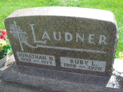
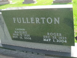
Maxine Fay “Mick” Laudner Fullerton
| Birth | : | 9 Mar 1926 Marble Rock, Floyd County, Iowa, USA |
| Death | : | 13 Nov 2008 Mason City, Cerro Gordo County, Iowa, USA |
| Burial | : | Riverside Cemetery, Rockford, Floyd County, USA |
| Coordinate | : | 43.0578003, -92.9464035 |
| Plot | : | Section 15 |
| Description | : | ROCKFORD, IOWA - Maxine F. "Mick" Fullerton, age 82, of 301 W. Main, Rockford, Floyd county, Iowa, died Thursday afternoon, November 13, 2008, at the Muse Norris Hospice Inpatient Unit in Mason City. Funeral services will be held on Monday, November 17, 2008 at the First United Methodist Church, 21 Third St. N.W., Rockford, with the Rev. Judy Wooton officiating. Interment will be next to Roger at Riverside Cemetery, Rockford. Maxine Fay was born on Mar. 9, 1926, in Marble Rock to Jonathan "Joney" and Ruby (Buckingham) Laudner. Maxine was the fifth of 11 children born into the family. After... Read More |
frequently asked questions (FAQ):
-
Where is Maxine Fay “Mick” Laudner Fullerton's memorial?
Maxine Fay “Mick” Laudner Fullerton's memorial is located at: Riverside Cemetery, Rockford, Floyd County, USA.
-
When did Maxine Fay “Mick” Laudner Fullerton death?
Maxine Fay “Mick” Laudner Fullerton death on 13 Nov 2008 in Mason City, Cerro Gordo County, Iowa, USA
-
Where are the coordinates of the Maxine Fay “Mick” Laudner Fullerton's memorial?
Latitude: 43.0578003
Longitude: -92.9464035
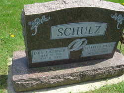
Family Members:
Parent

Spouse
Siblings

Flowers:


Nearby Cemetories:
1. Riverside Cemetery
Rockford, Floyd County, USA
Coordinate: 43.0578003, -92.9464035
2. Ulsterville Cemetery
Ulster Township, Floyd County, USA
Coordinate: 43.0936012, -92.8842010
3. Flood Creek Cemetery
Floyd County, USA
Coordinate: 43.0391998, -92.8538971
4. Rock Grove Township Cemetery
Nora Springs, Floyd County, USA
Coordinate: 43.1227989, -92.9880981
5. Rudd Evergreen Cemetery
Rudd, Floyd County, USA
Coordinate: 43.1417007, -92.9214020
6. Park Cemetery
Nora Springs, Floyd County, USA
Coordinate: 43.1444016, -92.9982986
7. Saint Marys Catholic Cemetery
Roseville, Floyd County, USA
Coordinate: 43.0090000, -92.8134000
8. West Saint Charles United Methodist Cemetery
Floyd County, USA
Coordinate: 43.0580597, -92.7897186
9. Westside Cemetery
Marble Rock, Floyd County, USA
Coordinate: 42.9556007, -92.8739014
10. Hillside Cemetery
Marble Rock, Floyd County, USA
Coordinate: 42.9583015, -92.8666992
11. Spring Grove Cemetery
Nora Springs, Floyd County, USA
Coordinate: 43.1631012, -93.0211029
12. Owens Grove Cemetery
Cerro Gordo County, USA
Coordinate: 43.0825005, -93.1144180
13. Saint Patricks Catholic Cemetery
Dougherty, Cerro Gordo County, USA
Coordinate: 42.9227791, -93.0294418
14. Eden Presbyterian Cemetery
Meroa, Mitchell County, USA
Coordinate: 43.2131004, -92.9103012
15. West End Cemetery
Meroa, Mitchell County, USA
Coordinate: 43.2216682, -92.9250031
16. Oakwood Cemetery
Floyd, Floyd County, USA
Coordinate: 43.1178017, -92.7307968
17. Dudley Cemetery
Dudley (historical), Mitchell County, USA
Coordinate: 43.2252998, -92.8743973
18. Rock Creek Cemetery
Meroa, Mitchell County, USA
Coordinate: 43.2352791, -92.9225006
19. Halls Grove Cemetery
Greene, Butler County, USA
Coordinate: 42.8840100, -92.8782300
20. Rock Falls Cemetery
Rock Falls, Cerro Gordo County, USA
Coordinate: 43.2122192, -93.0858307
21. Pleasant Grove Cemetery
Powersville, Floyd County, USA
Coordinate: 42.9441986, -92.7446976
22. Calvary Cemetery
Osage, Mitchell County, USA
Coordinate: 43.2238998, -92.8300018
23. Riverside Cemetery
Charles City, Floyd County, USA
Coordinate: 43.0766983, -92.6881027
24. West Fork Cemetery
Franklin County, USA
Coordinate: 42.8918991, -93.0836029