
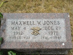
Maxwell Warren “Max” Jones
| Birth | : | 4 May 1912 Lamoni, Decatur County, Iowa, USA |
| Death | : | 29 Dec 1971 Pocatello, Bannock County, Idaho, USA |
| Burial | : | Rose Hill Cemetery, Lamoni, Decatur County, USA |
| Coordinate | : | 40.6250000, -93.9475021 |
| Plot | : | Plot 1420, Graves 1 & 2 |
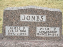
| Description | : | *****WORLD WAR II VETERAN***** MOTHER: Pearl Elizabeth Pitkin FATHER: James Franklin Jones WIFE: Theda Marguerite Jones m. 12 Oct 1940 - Malad, Oneida, Idaho FURTHER INFORMATION: 1. Western States Marriage Index, 1809-2011 Groom Last Name: JONES Groom First Name: Max Warren Bride Last Name: JONES Bride First Name: Theda Marguerite Place: Malad Date: 12 Oct 1940 County of Record: Oneida State: Idaho Volume: 3 Page: 391 Source Information: Ancestry.com. Web: Western States Marriage Index, 1809-2011 [database on-line]. Provo, UT, USA: Ancestry.com Operations, Inc., 2011. Original data: Western States Marriage Index. Brigham Young... Read More |
frequently asked questions (FAQ):
-
Where is Maxwell Warren “Max” Jones's memorial?
Maxwell Warren “Max” Jones's memorial is located at: Rose Hill Cemetery, Lamoni, Decatur County, USA.
-
When did Maxwell Warren “Max” Jones death?
Maxwell Warren “Max” Jones death on 29 Dec 1971 in Pocatello, Bannock County, Idaho, USA
-
Where are the coordinates of the Maxwell Warren “Max” Jones's memorial?
Latitude: 40.6250000
Longitude: -93.9475021
Family Members:
Parent

Flowers:


Nearby Cemetories:
1. Rose Hill Cemetery
Lamoni, Decatur County, USA
Coordinate: 40.6250000, -93.9475021
2. Sweet Home Cemetery
Fayette Township, Decatur County, USA
Coordinate: 40.5946550, -93.9566660
3. Lillie Cemetery
Lamoni, Decatur County, USA
Coordinate: 40.6565829, -93.9418602
4. Creveling Cemetery
Lamoni, Decatur County, USA
Coordinate: 40.6309232, -93.8984728
5. Hollen Cemetery
Lamoni, Decatur County, USA
Coordinate: 40.5952000, -94.0097000
6. Lewis Cemetery
Kellerton, Ringgold County, USA
Coordinate: 40.6588500, -94.0280500
7. Andover Cemetery
Andover, Harrison County, USA
Coordinate: 40.5588989, -93.9008026
8. Terre Haute Cemetery
Terre Haute, Decatur County, USA
Coordinate: 40.6836646, -93.8800621
9. Bucy Cemetery
Decatur City, Decatur County, USA
Coordinate: 40.6902056, -93.8869286
10. New Buda Cemetery
Davis City, Decatur County, USA
Coordinate: 40.6027448, -93.8314819
11. Patrick Cemetery
Riley Township, Ringgold County, USA
Coordinate: 40.5900000, -94.0586000
12. Downey Cemetery
Harrison County, USA
Coordinate: 40.5581017, -93.8606033
13. Elk Cemetery
Lamoni, Decatur County, USA
Coordinate: 40.7210467, -93.9390707
14. Mount Zion Cemetery
Riley Township, Ringgold County, USA
Coordinate: 40.5960000, -94.0731000
15. IOOF Cemetery
Davis City, Decatur County, USA
Coordinate: 40.6405800, -93.8174600
16. Miller Cemetery
Decatur County, USA
Coordinate: 40.7026000, -93.8592000
17. Anderson Cemetery
Eagleville, Harrison County, USA
Coordinate: 40.5293503, -93.9983292
18. Mount Pleasant No 2 Baptist Church Cemetery
Blythedale, Harrison County, USA
Coordinate: 40.5300010, -93.8916160
19. Old Davis City Cemetery
Davis City, Decatur County, USA
Coordinate: 40.6415100, -93.8115800
20. Brown Cemetery
Eagleville, Harrison County, USA
Coordinate: 40.5447006, -94.0357971
21. Millsap Cemetery
Grand River, Decatur County, USA
Coordinate: 40.7333310, -93.9502260
22. Maple Row Cemetery
Kellerton, Ringgold County, USA
Coordinate: 40.7077700, -94.0424500
23. Catholic Cemetery
Harrison County, USA
Coordinate: 40.5522003, -93.8380966
24. Payne Cemetery
Hatfield, Harrison County, USA
Coordinate: 40.5592003, -94.0733032