

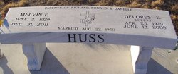
Melvin Frank Huss
| Birth | : | 2 Jun 1929 Herndon, Rawlins County, Kansas, USA |
| Death | : | 31 Dec 2011 Lexington, Dawson County, Nebraska, USA |
| Burial | : | Saint Anns Cemetery, Lexington, Dawson County, USA |
| Coordinate | : | 40.7789001, -99.7114029 |
| Plot | : | DIV. G, BLOCK 4, LOT 4, SPACE 3. |
| Description | : | Colonel Melvin Frank Huss, 82, of Lexington died Saturday, Dec. 31, 2011, at Plum Creek Care Center in Lexington. Melvin was born on June 2, 1929, at Herndon, Kansas to Frank and Pauline (Kogl) Huss. Melvin attended school at Herndon, Kansas. Following his schooling, he worked at the Omaha Stockyards. Melvin attended Auctioneer School in Mason City, Iowa. He auctioned at the McCook Livestock Market and did farm sales in the 1940's. On August 22, 1950, he was united in marriage to Delores E. Lorens at St. John's Catholic Church at Beardsley, Kansas. Three children were blessed to this union; Richard,... Read More |
frequently asked questions (FAQ):
-
Where is Melvin Frank Huss's memorial?
Melvin Frank Huss's memorial is located at: Saint Anns Cemetery, Lexington, Dawson County, USA.
-
When did Melvin Frank Huss death?
Melvin Frank Huss death on 31 Dec 2011 in Lexington, Dawson County, Nebraska, USA
-
Where are the coordinates of the Melvin Frank Huss's memorial?
Latitude: 40.7789001
Longitude: -99.7114029
Family Members:
Parent

Spouse

Siblings
Children
Flowers:


Nearby Cemetories:
1. Greenwood Cemetery
Lexington, Dawson County, USA
Coordinate: 40.7956467, -99.7286682
2. First United Methodist Church Columbarium
Lexington, Dawson County, USA
Coordinate: 40.7810000, -99.7397000
3. Evergreen Cemetery
Lexington, Dawson County, USA
Coordinate: 40.7639008, -99.6791992
4. Mount Hope Cemetery
Dawson County, USA
Coordinate: 40.8293991, -99.6733017
5. Hewitt Cemetery
Lexington, Dawson County, USA
Coordinate: 40.8588982, -99.7769012
6. Robb Cemetery
Smithfield, Gosper County, USA
Coordinate: 40.6710691, -99.6996001
7. Buffalo Grove Presbyterian Church Cemetery
Buffalo, Dawson County, USA
Coordinate: 40.8721000, -99.8270000
8. Hillside Cemetery
Dawson County, USA
Coordinate: 40.8946991, -99.7869034
9. Plum Creek Massacre Cemetery
Phelps County, USA
Coordinate: 40.6726840, -99.6058220
10. Grace Cemetery
Cozad, Dawson County, USA
Coordinate: 40.8602982, -99.8644028
11. Overton Cemetery
Overton, Dawson County, USA
Coordinate: 40.7317009, -99.5222015
12. Saint Johns Lutheran Cemetery
Lexington, Dawson County, USA
Coordinate: 40.9019012, -99.8458023
13. Quakerville Cemetery
Gosper County, USA
Coordinate: 40.6189003, -99.8097000
14. Adullam Cemetery
Bertrand, Phelps County, USA
Coordinate: 40.6265000, -99.5856000
15. Cozad Cemetery
Cozad, Dawson County, USA
Coordinate: 40.8605995, -99.9475021
16. Elwood Cemetery
Elwood, Gosper County, USA
Coordinate: 40.5999300, -99.8397300
17. Platte Valley Cemetery
Phelps County, USA
Coordinate: 40.6425018, -99.5028000
18. Keely Cemetery
Smithfield, Gosper County, USA
Coordinate: 40.5727500, -99.6563500
19. Saint Patricks Cemetery
Eddyville, Dawson County, USA
Coordinate: 40.9747009, -99.6093979
20. Sandstrom Cemetery
Phelps County, USA
Coordinate: 40.5983009, -99.5661011
21. Jewell Cemetery
Sumner, Dawson County, USA
Coordinate: 40.9599991, -99.5646973
22. Hope Lutheran Cemetery
Smithfield, Gosper County, USA
Coordinate: 40.5667500, -99.6800000
23. Fairview Cemetery
Dawson County, USA
Coordinate: 40.7719002, -99.9955978
24. Cottonwood Cemetery
Dawson County, USA
Coordinate: 40.9322014, -99.9197006