
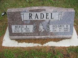
Merle Kenneth Radel
| Birth | : | 6 Oct 1923 Clayton, Hutchinson County, South Dakota, USA |
| Death | : | 21 Jun 2012 |
| Burial | : | Emery Community Cemetery, Emery, Hanson County, USA |
| Coordinate | : | 43.5572014, -97.6474991 |
| Plot | : | Blk 3, Lot 5, Grv 9 |
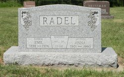
| Description | : | Merle Kenneth Radel was born October 6, 1923 near Clayton, SD at the farm of his parents, Emil and Anna (Wahl) Radel. He was baptized and became a member of the Plum Creek Baptist Church. He graduated from Emery High School in 1942. He served in the U.S. Navy from 1945 - 1946 and then returned home to the family farm. On December, 16 1972 he married Delores Griebel. They became members of the First Baptist Church in Emery. They farmed south of Emery until they retired in 2005 and moved to Sioux Falls. ... Read More |
frequently asked questions (FAQ):
-
Where is Merle Kenneth Radel's memorial?
Merle Kenneth Radel's memorial is located at: Emery Community Cemetery, Emery, Hanson County, USA.
-
When did Merle Kenneth Radel death?
Merle Kenneth Radel death on 21 Jun 2012 in
-
Where are the coordinates of the Merle Kenneth Radel's memorial?
Latitude: 43.5572014
Longitude: -97.6474991
Family Members:
Parent

Spouse
Flowers:


Nearby Cemetories:
1. Emery Community Cemetery
Emery, Hanson County, USA
Coordinate: 43.5572014, -97.6474991
2. Elfert Cemetery
Hanson County, USA
Coordinate: 43.5727997, -97.6868973
3. New Hope Cemetery
Hanson County, USA
Coordinate: 43.5102997, -97.6457977
4. Saint Martins Lutheran Cemetery
Hanson County, USA
Coordinate: 43.5729560, -97.7171440
5. Saint Martins Catholic Cemetery
Emery, Hanson County, USA
Coordinate: 43.6147003, -97.6271973
6. Plum Creek Baptist Cemetery
Emery, Hanson County, USA
Coordinate: 43.4905900, -97.6794100
7. Rasmussen Cemetery
Bridgewater, McCook County, USA
Coordinate: 43.5283012, -97.5567017
8. Saint Peters Lutheran Cemetery
Clayton, Hutchinson County, USA
Coordinate: 43.4721985, -97.6557999
9. Suelzle Seventh-day Adventist Cemetery
Milltown, Hutchinson County, USA
Coordinate: 43.4869194, -97.7195358
10. Bridgewater Cemetery
Bridgewater, McCook County, USA
Coordinate: 43.5541600, -97.5059400
11. Schrag Farm Cemetery
Bridgewater, McCook County, USA
Coordinate: 43.4760720, -97.5570940
12. Hofer Cemetery
Freeman, Hutchinson County, USA
Coordinate: 43.4726830, -97.5299150
13. Rademacher Cemetery
Hutchinson County, USA
Coordinate: 43.4361000, -97.6580963
14. Neu Hutterthal Mennonite Cemetery
Hutchinson County, USA
Coordinate: 43.4510040, -97.5605320
15. Saint Stephens Cemetery
Bridgewater, McCook County, USA
Coordinate: 43.5574989, -97.4766998
16. Old Elmspring Hutterite Cemetery
Alexandria, Hanson County, USA
Coordinate: 43.4984894, -97.7991001
17. Salem Mennonite Brethren Church Cemetery
Hutchinson County, USA
Coordinate: 43.4440240, -97.5660950
18. Green Hill Cemetery
Alexandria, Hanson County, USA
Coordinate: 43.6582985, -97.7641983
19. Saint Marys Cemetery
Alexandria, Hanson County, USA
Coordinate: 43.6486015, -97.7855988
20. Wolf Creek Congregational Cemetery
Freeman, Hutchinson County, USA
Coordinate: 43.4150150, -97.6385980
21. Unity Lutheran Cemetery
Freeman, Hutchinson County, USA
Coordinate: 43.4151550, -97.6198680
22. Pleasant Prairie Cemetery
Bridgewater, McCook County, USA
Coordinate: 43.5430984, -97.4496994
23. Friedhof Rockport Colony Cemetery
Alexandria, Hanson County, USA
Coordinate: 43.5834400, -97.8451200
24. New Elmspring Hutterite Cemetery
Parkston, Hutchinson County, USA
Coordinate: 43.4899411, -97.8312111