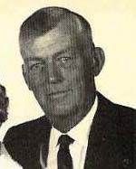
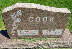
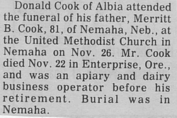
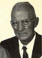
Merritt Burdette Cook
| Birth | : | 26 Aug 1905 Arlington, Washington County, Nebraska, USA |
| Death | : | 22 Nov 1986 Enterprise, Wallowa County, Oregon, USA |
| Burial | : | Nemaha Cemetery, Nemaha, Sac County, USA |
| Coordinate | : | 42.5102997, -95.0905991 |
| Description | : | Cook was born Aug. 26, 1905 to Myron Henry and Lenora (Eakin) Cook in Arlington, Neb. He was a graduate of Arlington High School in Nebraska and the Herdsman's Course at Iowa State College. He married Ruth Pauline Jensen on Oct. 3, 1929 in Omaha, Neb. He developed an apiary and dairy business in Nebraska in 1930. He joined the National Ayrshire Association in 1939. The family moved to Nemaha in 1940. He served as a regional director of the association for 10 years and was elected national president in 1975. In 1969 and 1972 he participated in the Ayrshire World Conference in Canada and Finland and was a judge at the 1970 Colubian Exposition in South America. He was... Read More |
frequently asked questions (FAQ):
-
Where is Merritt Burdette Cook's memorial?
Merritt Burdette Cook's memorial is located at: Nemaha Cemetery, Nemaha, Sac County, USA.
-
When did Merritt Burdette Cook death?
Merritt Burdette Cook death on 22 Nov 1986 in Enterprise, Wallowa County, Oregon, USA
-
Where are the coordinates of the Merritt Burdette Cook's memorial?
Latitude: 42.5102997
Longitude: -95.0905991
Family Members:
Parent
Spouse
Siblings
Flowers:
Nearby Cemetories:
1. Nemaha Cemetery
Nemaha, Sac County, USA
Coordinate: 42.5102997, -95.0905991
2. Sacred Heart Cemetery
Early, Sac County, USA
Coordinate: 42.4650002, -95.1446991
3. Early Union Cemetery
Early, Sac County, USA
Coordinate: 42.4578018, -95.1425018
4. Donna Lynn Salis-Christensen Burial Plot
Newell, Buena Vista County, USA
Coordinate: 42.5882134, -95.0544960
5. Sac County Farm Cemetery
Early, Sac County, USA
Coordinate: 42.4295560, -95.1175190
6. Protestant Union Cemetery
Early, Sac County, USA
Coordinate: 42.4294014, -95.1483002
7. Chase Cemetery
Sac County, USA
Coordinate: 42.5036011, -95.2288971
8. Immanuel Reformed Cemetery
Schaller, Sac County, USA
Coordinate: 42.5396996, -95.2294006
9. Oakland Cemetery
Sac City, Sac County, USA
Coordinate: 42.4272100, -94.9910760
10. Newell Catholic Prairie Cemetery
Newell, Buena Vista County, USA
Coordinate: 42.6144000, -95.0328000
11. German Methodist Cemetery
Schaller, Sac County, USA
Coordinate: 42.5045000, -95.2481000
12. Newell Cemetery
Newell, Buena Vista County, USA
Coordinate: 42.6123800, -94.9994800
13. Storm Lake Cemetery
Storm Lake, Buena Vista County, USA
Coordinate: 42.6352800, -95.1744400
14. Emmanuel Cemetery
Cook Township, Sac County, USA
Coordinate: 42.3993988, -95.2063980
15. Cory Grove Cemetery
Sac City, Sac County, USA
Coordinate: 42.3932991, -94.9788971
16. Cook Center Cemetery
Schaller, Sac County, USA
Coordinate: 42.4432983, -95.2649994
17. Saint Mary's Catholic Cemetery
Storm Lake, Buena Vista County, USA
Coordinate: 42.6470000, -95.1660000
18. Cedar Cemetery
Sac City, Sac County, USA
Coordinate: 42.4430000, -94.9110000
19. Saint Josephs Catholic Church Cemetery
Schaller, Sac County, USA
Coordinate: 42.5035000, -95.3095000
20. Schaller Cemetery
Schaller, Sac County, USA
Coordinate: 42.5046000, -95.3117600
21. Saint John Cemetery
Williams Township, Calhoun County, USA
Coordinate: 42.4747009, -94.8672028
22. Salem Reform Cemetery
Sac County, USA
Coordinate: 42.3555984, -95.1866989
23. Buena Vista Memorial Park Cemetery
Storm Lake, Buena Vista County, USA
Coordinate: 42.6539001, -95.2339020
24. Maple Valley Township Cemetery
Alta, Buena Vista County, USA
Coordinate: 42.5752600, -95.3199980

