

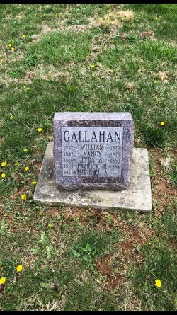
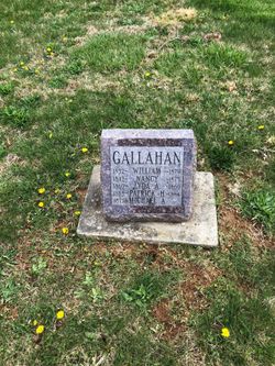
Michael Arterburn Gallahan
| Birth | : | 9 Oct 1871 Washington County, Indiana, USA |
| Death | : | 6 Oct 1898 Jefferson County, Kentucky, USA |
| Burial | : | Adams Rural Cemetery, Adams, Jefferson County, USA |
| Coordinate | : | 43.8055400, -76.0242000 |
| Description | : | Son of William Gallahan and Nancy Jane Cornwell. No additional information. |
frequently asked questions (FAQ):
-
Where is Michael Arterburn Gallahan's memorial?
Michael Arterburn Gallahan's memorial is located at: Adams Rural Cemetery, Adams, Jefferson County, USA.
-
When did Michael Arterburn Gallahan death?
Michael Arterburn Gallahan death on 6 Oct 1898 in Jefferson County, Kentucky, USA
-
Where are the coordinates of the Michael Arterburn Gallahan's memorial?
Latitude: 43.8055400
Longitude: -76.0242000
Family Members:
Parent
Siblings


Nearby Cemetories:
1. Adams Rural Cemetery
Adams, Jefferson County, USA
Coordinate: 43.8055400, -76.0242000
2. Elmwood Cemetery
Adams, Jefferson County, USA
Coordinate: 43.8143997, -76.0299988
3. Thompson Cemetery
Adams, Jefferson County, USA
Coordinate: 43.8196983, -75.9775009
4. Giddingsville Cemetery
Jefferson County, USA
Coordinate: 43.7742004, -76.0556030
5. Dickinson Family Cemetery
Ellisburg, Jefferson County, USA
Coordinate: 43.7816180, -76.0730860
6. Union Cemetery
Adams Center, Jefferson County, USA
Coordinate: 43.8532982, -76.0089035
7. Gould Cemetery
Lorraine, Jefferson County, USA
Coordinate: 43.7887400, -75.9582000
8. Randall Cemetery
Lorraine, Jefferson County, USA
Coordinate: 43.7578011, -75.9993973
9. Green Settlement Cemetery
Green Settlement, Jefferson County, USA
Coordinate: 43.8557014, -76.0378036
10. Paul's Corner Cemetery
Adams, Jefferson County, USA
Coordinate: 43.8080000, -76.0980000
11. Ross Corners Cemetery
Rodman, Jefferson County, USA
Coordinate: 43.8024200, -75.9475200
12. Lorraine Rural Cemetery
Lorraine, Jefferson County, USA
Coordinate: 43.7666300, -75.9623700
13. Adams State Road Cemetery
Honeyville, Jefferson County, USA
Coordinate: 43.8600006, -75.9918976
14. Jerusalem Road
Lorraine, Jefferson County, USA
Coordinate: 43.7899440, -75.9383060
15. Evergreen Cemetery
Henderson, Jefferson County, USA
Coordinate: 43.8132200, -76.1156800
16. Haights Corners Cemetery
Lorraine, Jefferson County, USA
Coordinate: 43.7389870, -76.0208600
17. Saint Johns Cemetery
Jefferson County, USA
Coordinate: 43.8135986, -76.1164017
18. Saint Cecilia Catholic Cemetery
Henderson, Jefferson County, USA
Coordinate: 43.8118629, -76.1168823
19. Lyman Cemetery
Adams, Jefferson County, USA
Coordinate: 43.7505989, -75.9666977
20. Wood Family Cemetery
Rodman, Jefferson County, USA
Coordinate: 43.8502808, -75.9450073
21. Belleville Cemetery
Belleville, Jefferson County, USA
Coordinate: 43.7798320, -76.1193970
22. Saxe Cemetery
Ellisburg, Jefferson County, USA
Coordinate: 43.7611008, -76.1057968
23. Pierrepont Manor Cemetery
Pierrepont Manor, Jefferson County, USA
Coordinate: 43.7356300, -76.0616074
24. Isham Cemetery
Rodman, Jefferson County, USA
Coordinate: 43.8521996, -75.9349976