
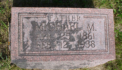


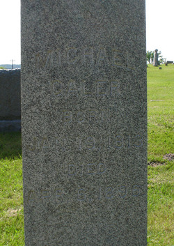
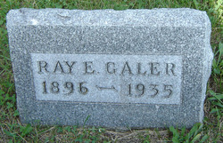
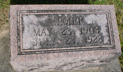
Michael Monroe Galer
| Birth | : | 25 Apr 1861 Cox Creek Township, Clayton County, Iowa, USA |
| Death | : | 12 Feb 1938 Cox Creek Township, Clayton County, Iowa, USA |
| Burial | : | Sunset Memorial Park and Mausoleum, Chester, Chesterfield County, USA |
| Coordinate | : | 37.3539009, -77.4194031 |
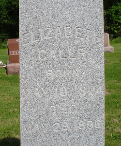
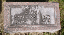
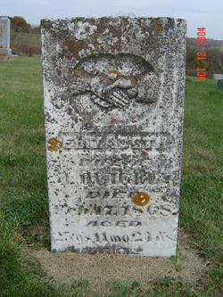
| Description | : | Son of Michael Galer & Elizabeth Dennis. Husband of Emma Parsons, married 1895. |
frequently asked questions (FAQ):
-
Where is Michael Monroe Galer's memorial?
Michael Monroe Galer's memorial is located at: Sunset Memorial Park and Mausoleum, Chester, Chesterfield County, USA.
-
When did Michael Monroe Galer death?
Michael Monroe Galer death on 12 Feb 1938 in Cox Creek Township, Clayton County, Iowa, USA
-
Where are the coordinates of the Michael Monroe Galer's memorial?
Latitude: 37.3539009
Longitude: -77.4194031
Family Members:
Parent
Spouse
Siblings

Children
Flowers:


Nearby Cemetories:
1. Sunset Memorial Park and Mausoleum
Chester, Chesterfield County, USA
Coordinate: 37.3539009, -77.4194031
2. Moores Cemetery
Chester, Chesterfield County, USA
Coordinate: 37.3572540, -77.4173950
3. Perdue Cemetery
Chester, Chesterfield County, USA
Coordinate: 37.3635570, -77.4221360
4. Saint Johns Episcopal Church Memorial Garden
Chester, Chesterfield County, USA
Coordinate: 37.3546280, -77.4428280
5. Brown Family Cemetery
Bellwood, Chesterfield County, USA
Coordinate: 37.3668830, -77.3925020
6. Grace Lutheran Church Memorial Gardens
Chester, Chesterfield County, USA
Coordinate: 37.3366250, -77.4478420
7. Hatcher Family Cemetery
Drewrys Bluff, Chesterfield County, USA
Coordinate: 37.3829460, -77.4194946
8. Lively Community Cemetery
Chester, Chesterfield County, USA
Coordinate: 37.3392260, -77.4646280
9. Eyler Family Cemetery
Chesterfield County, USA
Coordinate: 37.3412000, -77.3695000
10. Brown Cemetery
Chesterfield County, USA
Coordinate: 37.3144520, -77.4391020
11. Morgan's Mount
Chester, Cheshire West and Chester Unitary Authority, England
Coordinate: 37.3187550, -77.4500380
12. Mount Minnis Memorial Park
Chester, Chesterfield County, USA
Coordinate: 37.3153000, -77.3938980
13. Centralia Cemetery
Chester, Chesterfield County, USA
Coordinate: 37.3846016, -77.4601364
14. Mitchell Family Cemetery #3
Crozier, Goochland County, USA
Coordinate: 37.3898000, -77.4771400
15. Salem Baptist Church Cemetery
Courthouse Green, Chesterfield County, USA
Coordinate: 37.3769798, -77.4869995
16. Salem Church Cemetery
Chesterfield, Chesterfield County, USA
Coordinate: 37.3784850, -77.4876230
17. Bellwood Cemetery
Chester, Chesterfield County, USA
Coordinate: 37.4132840, -77.4395700
18. Cobbs Cemetery
Enon, Chesterfield County, USA
Coordinate: 37.3211700, -77.3495900
19. Longfield Plantation - Burton Family Cemetery
Henrico County, USA
Coordinate: 37.4115319, -77.3788165
20. Henrico Parish Church Cemetery
Varina, Henrico County, USA
Coordinate: 37.3817440, -77.3372480
21. Bullington Cemetery
Varina, Henrico County, USA
Coordinate: 37.4093035, -77.3497769
22. Bermuda Memorial Park
Enon, Chesterfield County, USA
Coordinate: 37.3428001, -77.3193970
23. Brick House Graveyard
Colonial Heights, Colonial Heights City, USA
Coordinate: 37.2849220, -77.3658140
24. Woodlawn Baptist Church Cemetery
Colonial Heights, Colonial Heights City, USA
Coordinate: 37.2714070, -77.4154460