
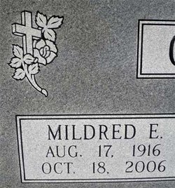
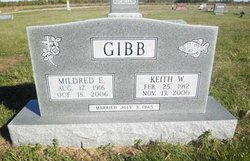
Mildred Edith Thompson Gibb
| Birth | : | 17 Aug 1916 Cedar Point, Chase County, Kansas, USA |
| Death | : | 18 Oct 2006 Emporia, Lyon County, Kansas, USA |
| Burial | : | Rosemary Hill Cemetery, Bronson, Levy County, USA |
| Coordinate | : | 29.4533400, -82.6356000 |
| Description | : | ************************************** (Emporia Gazette - Oct. 20, 2006): The service for Mildred "Millie" Edith Gibb of Elmdale will be at 2 p.m. Saturday in the Elmdale United Methodist Church. The Rev. John Hastings will conduct the service. Burial will be in Elmdale Cemetery. Friends may call at the Brown-Bennett-Alexander Funeral Home in Cottonwood Falls until 8 p.m. today and at the church from noon Saturday until service time. Memorial contributions to the Elmdale United Methodist Church may be sent in care of the funeral home, 201 Cherry, Cottonwood Falls, KS. Mrs. Gibb died Wednesday, Oct. 18, 2006, at Newman Regional Health. She was 90. She... Read More |
frequently asked questions (FAQ):
-
Where is Mildred Edith Thompson Gibb's memorial?
Mildred Edith Thompson Gibb's memorial is located at: Rosemary Hill Cemetery, Bronson, Levy County, USA.
-
When did Mildred Edith Thompson Gibb death?
Mildred Edith Thompson Gibb death on 18 Oct 2006 in Emporia, Lyon County, Kansas, USA
-
Where are the coordinates of the Mildred Edith Thompson Gibb's memorial?
Latitude: 29.4533400
Longitude: -82.6356000
Family Members:
Parent

Spouse
Siblings
Children
Flowers:


Nearby Cemetories:
1. Rosemary Hill Cemetery
Bronson, Levy County, USA
Coordinate: 29.4533400, -82.6356000
2. Robinson-Jerrels Cemetery
Bronson, Levy County, USA
Coordinate: 29.4542730, -82.6392460
3. Jim Milton Cemetery
Bronson, Levy County, USA
Coordinate: 29.4511200, -82.6311800
4. Coulter Cemetery
Bronson, Levy County, USA
Coordinate: 29.4469800, -82.6354400
5. Weems Family Cemetery
Bronson, Levy County, USA
Coordinate: 29.3876410, -82.6249940
6. Hamp Smith Cemetery
Levy County, USA
Coordinate: 29.3799992, -82.6130981
7. Ebenezer Baptist Church Cemetery
Chiefland, Levy County, USA
Coordinate: 29.5089800, -82.7231000
8. Pisarri Family Cemetery
Archer, Alachua County, USA
Coordinate: 29.5380080, -82.5639660
9. Thomas Family Cemetery
Archer, Alachua County, USA
Coordinate: 29.5278880, -82.5400880
10. New Zion Cemetery
Levy County, USA
Coordinate: 29.4941998, -82.7557983
11. Shiloh Missionary Baptist Church Cemetery
Archer, Alachua County, USA
Coordinate: 29.5190760, -82.5287950
12. Bethlehem Methodist Episcopal Cemetery
Archer, Alachua County, USA
Coordinate: 29.5224150, -82.5276650
13. Laurel Hill Cemetery
Archer, Alachua County, USA
Coordinate: 29.5249996, -82.5297012
14. Mount Zion Cemetery
Raleigh, Levy County, USA
Coordinate: 29.4242094, -82.4996343
15. Mount Pleasant Missionary Baptist Church Cemetery
Williston, Levy County, USA
Coordinate: 29.3823190, -82.5143280
16. Carter Cemetery
Chiefland, Levy County, USA
Coordinate: 29.4523563, -82.7845323
17. Levyville Cemetery
Chiefland, Levy County, USA
Coordinate: 29.4619007, -82.7881012
18. Martin Cemetery
Trenton, Gilchrist County, USA
Coordinate: 29.5851221, -82.7111501
19. Saint Marks Cemetery
Newberry, Alachua County, USA
Coordinate: 29.5970001, -82.5899963
20. Orange Hill Cemetery
Williston, Levy County, USA
Coordinate: 29.3813992, -82.4753036
21. Saint Peters Cemetery
Archer, Alachua County, USA
Coordinate: 29.5777778, -82.5219440
22. Saint Joseph Missionary Baptist Cemetery
Archer, Alachua County, USA
Coordinate: 29.4885660, -82.4544740
23. Shady Grove Primitive Baptist Church Cemetery
Trenton, Gilchrist County, USA
Coordinate: 29.5776750, -82.7644730
24. Pinesville Cemetery
Archer, Alachua County, USA
Coordinate: 29.5888175, -82.5184688