
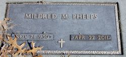
Mildred Mae “Millie” Hennigar Phelps
| Birth | : | 21 Nov 1930 Sheffield, Franklin County, Iowa, USA |
| Death | : | 22 Apr 2011 Spencer, Clay County, Iowa, USA |
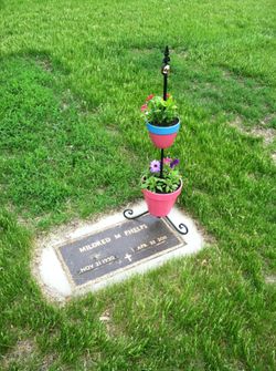
| Burial | : | Riverside Cemetery, Spencer, Clay County, USA |
| Coordinate | : | 43.1441994, -95.1671982 |
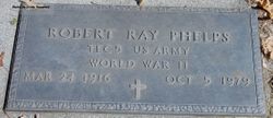
| Description | : | Mildred Mae Phelps November 21, 1930 - April 22, 2011 Mildred "Millie" Mae Phelps, the daughter of Henry and Miriam (Davis) Hennigar, was born November 21, 1930 in Sheffield, IA. Her childhood years were spent in Clarion, Iowa, where she received her education in the Clarion School System. Millie married Robert Ray Phelps on February 2, 1952 in Jackson, MN. They made their home in Royal, where she spent her time raising her family. She took a lot of pride in helping with community projects in Royal, including establishing a Youth Center and volunteering with the fund raising, construction and development... Read More |
frequently asked questions (FAQ):
-
Where is Mildred Mae “Millie” Hennigar Phelps's memorial?
Mildred Mae “Millie” Hennigar Phelps's memorial is located at: Riverside Cemetery, Spencer, Clay County, USA.
-
When did Mildred Mae “Millie” Hennigar Phelps death?
Mildred Mae “Millie” Hennigar Phelps death on 22 Apr 2011 in Spencer, Clay County, Iowa, USA
-
Where are the coordinates of the Mildred Mae “Millie” Hennigar Phelps's memorial?
Latitude: 43.1441994
Longitude: -95.1671982
Family Members:
Flowers:


Nearby Cemetories:
1. Riverside Cemetery
Spencer, Clay County, USA
Coordinate: 43.1441994, -95.1671982
2. Dewey Readmore Books Memorial
Spencer, Clay County, USA
Coordinate: 43.1403999, -95.1443024
3. North Lawn Cemetery
Spencer, Clay County, USA
Coordinate: 43.1600000, -95.1470000
4. Evergreen Cemetery
Clay County, USA
Coordinate: 43.2052994, -95.2086029
5. Fairview Cemetery
Clay County, USA
Coordinate: 43.1899986, -95.0800018
6. Swedish Lutheran Cemetery
Royal, Clay County, USA
Coordinate: 43.0683000, -95.2350000
7. Dickens Cemetery
Dickens, Clay County, USA
Coordinate: 43.1280000, -95.0155000
8. Rosehill Cemetery
Clay County, USA
Coordinate: 43.0368996, -95.0919037
9. Lone Tree Cemetery
Everly, Clay County, USA
Coordinate: 43.1411018, -95.3347015
10. Little Sioux Lutheran Cemetery
Milford, Dickinson County, USA
Coordinate: 43.2702065, -95.2109528
11. First Reformed Cemetery
Clay County, USA
Coordinate: 43.2399500, -95.2889000
12. Lincoln Cemetery
Rossie, Clay County, USA
Coordinate: 43.0111008, -95.2313995
13. Willow Creek Cemetery
Royal, Clay County, USA
Coordinate: 43.0214005, -95.2885971
14. Liberty Cemetery
Greenville, Clay County, USA
Coordinate: 42.9897003, -95.1417007
15. Clay Center Cemetery
Royal, Clay County, USA
Coordinate: 43.0410995, -95.3272018
16. Milford Cemetery
Milford, Dickinson County, USA
Coordinate: 43.3092003, -95.1481018
17. TriMello Cemetery
Royal, Clay County, USA
Coordinate: 43.0682983, -95.3728027
18. Logan Township Cemetery
Clay County, USA
Coordinate: 43.0489006, -94.9747009
19. Zion Methodist Cemetery
Clay County, USA
Coordinate: 42.9808006, -95.2497025
20. Calvary Cemetery
Milford, Dickinson County, USA
Coordinate: 43.3213997, -95.1688995
21. Fanny Fern Cemetery
Clay County, USA
Coordinate: 42.9530983, -95.1607971
22. Crown Hill Cemetery
Ruthven, Palo Alto County, USA
Coordinate: 43.1328011, -94.8878021
23. Calvary Cemetery
Ruthven, Palo Alto County, USA
Coordinate: 43.1314011, -94.8869019
24. Westport Cemetery
Dickinson County, USA
Coordinate: 43.3130989, -95.3289032