
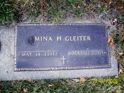
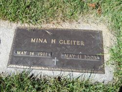
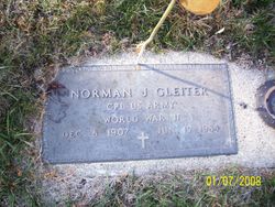
Mina Hazel Vande Mark Gleiter
| Birth | : | 14 May 1911 Clay Township, Clay County, Iowa, USA |
| Death | : | 11 May 2003 Saint James, Watonwan County, Minnesota, USA |
| Burial | : | North Lawn Cemetery, Spencer, Clay County, USA |
| Coordinate | : | 43.1600000, -95.1470000 |
| Description | : | A funeral service for Mina Gleiter, 91, of St James, Minnesota, formerly of Everly, was held, Wednesday, May 13, 2003 at the Warner Funeral Home Chapel in Spencer. The Rev. Tom Dettmer led the 1:30 p.m. service Mrs. Gleiter died at Pleasant View Nursing Home in St. James on Sunday, May 11 Burial was at North Lawn Memorial Park Cemetery in Spencer Warner Funeral Home in Spencer was in charge of arrangements Mina Hazel Gleiter, the daughter of George and Ethel (Clark) VandeMark, was born May 14, 1911 in Clay Township, Clay County. Her childhood years were spent in that... Read More |
frequently asked questions (FAQ):
-
Where is Mina Hazel Vande Mark Gleiter's memorial?
Mina Hazel Vande Mark Gleiter's memorial is located at: North Lawn Cemetery, Spencer, Clay County, USA.
-
When did Mina Hazel Vande Mark Gleiter death?
Mina Hazel Vande Mark Gleiter death on 11 May 2003 in Saint James, Watonwan County, Minnesota, USA
-
Where are the coordinates of the Mina Hazel Vande Mark Gleiter's memorial?
Latitude: 43.1600000
Longitude: -95.1470000
Family Members:
Parent
Spouse
Siblings

Children
Flowers:


Nearby Cemetories:
1. North Lawn Cemetery
Spencer, Clay County, USA
Coordinate: 43.1600000, -95.1470000
2. Dewey Readmore Books Memorial
Spencer, Clay County, USA
Coordinate: 43.1403999, -95.1443024
3. Riverside Cemetery
Spencer, Clay County, USA
Coordinate: 43.1441994, -95.1671982
4. Fairview Cemetery
Clay County, USA
Coordinate: 43.1899986, -95.0800018
5. Evergreen Cemetery
Clay County, USA
Coordinate: 43.2052994, -95.2086029
6. Dickens Cemetery
Dickens, Clay County, USA
Coordinate: 43.1280000, -95.0155000
7. Swedish Lutheran Cemetery
Royal, Clay County, USA
Coordinate: 43.0683000, -95.2350000
8. Little Sioux Lutheran Cemetery
Milford, Dickinson County, USA
Coordinate: 43.2702065, -95.2109528
9. Rosehill Cemetery
Clay County, USA
Coordinate: 43.0368996, -95.0919037
10. First Reformed Cemetery
Clay County, USA
Coordinate: 43.2399500, -95.2889000
11. Lone Tree Cemetery
Everly, Clay County, USA
Coordinate: 43.1411018, -95.3347015
12. Milford Cemetery
Milford, Dickinson County, USA
Coordinate: 43.3092003, -95.1481018
13. Lincoln Cemetery
Rossie, Clay County, USA
Coordinate: 43.0111008, -95.2313995
14. Calvary Cemetery
Milford, Dickinson County, USA
Coordinate: 43.3213997, -95.1688995
15. Logan Township Cemetery
Clay County, USA
Coordinate: 43.0489006, -94.9747009
16. Liberty Cemetery
Greenville, Clay County, USA
Coordinate: 42.9897003, -95.1417007
17. Willow Creek Cemetery
Royal, Clay County, USA
Coordinate: 43.0214005, -95.2885971
18. Clay Center Cemetery
Royal, Clay County, USA
Coordinate: 43.0410995, -95.3272018
19. TriMello Cemetery
Royal, Clay County, USA
Coordinate: 43.0682983, -95.3728027
20. Crown Hill Cemetery
Ruthven, Palo Alto County, USA
Coordinate: 43.1328011, -94.8878021
21. Calvary Cemetery
Ruthven, Palo Alto County, USA
Coordinate: 43.1314011, -94.8869019
22. Zion Methodist Cemetery
Clay County, USA
Coordinate: 42.9808006, -95.2497025
23. Westport Cemetery
Dickinson County, USA
Coordinate: 43.3130989, -95.3289032
24. Okoboji Cemetery
Arnolds Park, Dickinson County, USA
Coordinate: 43.3649406, -95.1303558