

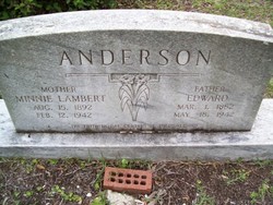
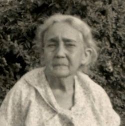
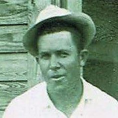
Minnie Cornelia Lambert Anderson
| Birth | : | 15 Aug 1891 Georgetown County, South Carolina, USA |
| Death | : | 12 Feb 1942 Georgetown County, South Carolina, USA |
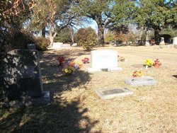
| Burial | : | Viola Cemetery, Viola, Mercer County, USA |
| Coordinate | : | 41.2111015, -90.5914001 |
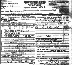
| Description | : | Minnie Cornelia Lambert married three times: 1. Duncan Lee Lambert, c. 1890 - 1918 2. William Lane Johnson, 1855 - 1922 3. Edward Anderson, 1882 - 1942 --- South Carolina, Death Records, 1821-1955 Name: Minnie Cornelia Anderson Death Date: 12 Feb 1942 Age at Death: 50 Born: Aug 15, 1891, Georgetown Co. Gender: Female Color: White County of Death: Georgetown Marital Status: Married Husband: Edward Anderson Father: William Lambert, b. Georgetown Co. Mother: Maggie Thomas, b. Georgetown Co. Burial: Feb 13, 1942, Elmwood Cemetery Undertaker: Mayer FH, Georgetown, SC Informant: Sammie Lambert, Georgetown, SC Certificate Number: 002088 Volume Number: 6 |
frequently asked questions (FAQ):
-
Where is Minnie Cornelia Lambert Anderson's memorial?
Minnie Cornelia Lambert Anderson's memorial is located at: Viola Cemetery, Viola, Mercer County, USA.
-
When did Minnie Cornelia Lambert Anderson death?
Minnie Cornelia Lambert Anderson death on 12 Feb 1942 in Georgetown County, South Carolina, USA
-
Where are the coordinates of the Minnie Cornelia Lambert Anderson's memorial?
Latitude: 41.2111015
Longitude: -90.5914001
Family Members:
Parent
Spouse
Siblings

Children
Flowers:


Nearby Cemetories:
1. Viola Cemetery
Viola, Mercer County, USA
Coordinate: 41.2111015, -90.5914001
2. Saint Johns Cemetery
Viola, Mercer County, USA
Coordinate: 41.2144012, -90.5871964
3. Graham Cemetery
Aledo, Mercer County, USA
Coordinate: 41.2050352, -90.6443032
4. Farlow Grove Cemetery
Matherville, Mercer County, USA
Coordinate: 41.2536011, -90.6003036
5. Bethel Cemetery
Mercer County, USA
Coordinate: 41.2043991, -90.6547012
6. Cooper Cemetery
Viola, Mercer County, USA
Coordinate: 41.1674995, -90.5419006
7. Bridger Cemetery
Mercer County, USA
Coordinate: 41.1519012, -90.5764008
8. Saint Josephs Cemetery
Preemption, Mercer County, USA
Coordinate: 41.2621994, -90.6493988
9. Hopewell Cemetery
New Windsor, Mercer County, USA
Coordinate: 41.1925011, -90.5042038
10. Merryman Littlefield Cemetery
Cable, Mercer County, USA
Coordinate: 41.2510986, -90.4957962
11. Corns Cemetery
Mercer County, USA
Coordinate: 41.2677994, -90.6725006
12. Mann Cemetery
Viola, Mercer County, USA
Coordinate: 41.1413994, -90.5297012
13. Cable Cemetery
Cable, Mercer County, USA
Coordinate: 41.2791210, -90.5035790
14. German Cemetery
Sherrard, Mercer County, USA
Coordinate: 41.3005981, -90.5307999
15. Artz Cemetery
Mercer County, USA
Coordinate: 41.2350006, -90.7244034
16. Preemption Cemetery
Preemption, Mercer County, USA
Coordinate: 41.3196983, -90.5805969
17. Sugar Grove Cemetery
Sugar Grove, Mercer County, USA
Coordinate: 41.2393990, -90.7324982
18. New Windsor Cemetery
New Windsor, Mercer County, USA
Coordinate: 41.2103004, -90.4421997
19. Aledo Cemetery
Aledo, Mercer County, USA
Coordinate: 41.1935997, -90.7433014
20. Calvary Lutheran Cemetery
New Windsor, Mercer County, USA
Coordinate: 41.2036667, -90.4369202
21. Mercer County Farm Cemetery
Sugar Grove, Mercer County, USA
Coordinate: 41.2463300, -90.7398100
22. Friends Cemetery
Sherrard, Mercer County, USA
Coordinate: 41.3175011, -90.5263977
23. Eggleston Cemetery
Preemption Township, Mercer County, USA
Coordinate: 41.3227884, -90.6441175
24. McPherren Cemetery
Aledo, Mercer County, USA
Coordinate: 41.1488991, -90.7260971