
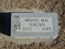
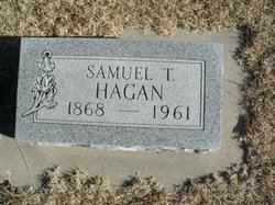
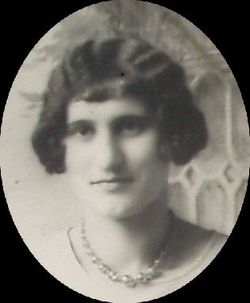
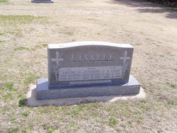
Minnie Mae Brooks Hagan
| Birth | : | 7 Nov 1870 Morgan County, Indiana, USA |
| Death | : | 25 Nov 1949 Clayton, Norton County, Kansas, USA |
| Burial | : | St. Cross Churchyard, Holywell, City of Oxford, England |
| Coordinate | : | 51.7558380, -1.2479690 |
| Plot | : | Lot 2, Sec. 13 |
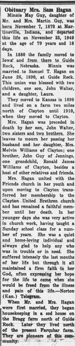
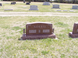
| Description | : | In 1916 Samuel and Minnie May Guy Hagan adopted a little girl, Laura Ida Brooks FAG #60459079. Laura was 5 years old and her mother had just died after giving birth to her baby brother, Charles James Brooks. FAG # 50857001. The parents of Laura were Jacob 'Jakie' James Brooks FAG # 40432222 and Ida May Wright l # 40432516. Charles and another sister Josephine Francis Brooks FAG # 50920481 were adopted by Roy and Cecile Amack Norris. Contributor: Cathy Cadd (46866756) • [email protected] |
frequently asked questions (FAQ):
-
Where is Minnie Mae Brooks Hagan's memorial?
Minnie Mae Brooks Hagan's memorial is located at: St. Cross Churchyard, Holywell, City of Oxford, England.
-
When did Minnie Mae Brooks Hagan death?
Minnie Mae Brooks Hagan death on 25 Nov 1949 in Clayton, Norton County, Kansas, USA
-
Where are the coordinates of the Minnie Mae Brooks Hagan's memorial?
Latitude: 51.7558380
Longitude: -1.2479690
Family Members:
Parent
Spouse
Siblings
Flowers:


Nearby Cemetories:
1. St. Cross Churchyard
Holywell, City of Oxford, England
Coordinate: 51.7558380, -1.2479690
2. Saint Cross Church
Oxford, City of Oxford, England
Coordinate: 51.7561880, -1.2479120
3. St Peter-in-the-East Churchyard
Oxford, City of Oxford, England
Coordinate: 51.7536111, -1.2500000
4. New College
Oxford, City of Oxford, England
Coordinate: 51.7543090, -1.2515310
5. Queens College Chapel
Oxford, City of Oxford, England
Coordinate: 51.7532340, -1.2506990
6. Mansfield College Chapel
Oxford, City of Oxford, England
Coordinate: 51.7576410, -1.2523340
7. Wadham College Chapel
Oxford, City of Oxford, England
Coordinate: 51.7560700, -1.2540350
8. Austin Friars Church
Oxford, City of Oxford, England
Coordinate: 51.7553710, -1.2541550
9. Magdalen College Chapel
Oxford, City of Oxford, England
Coordinate: 51.7519830, -1.2469820
10. University College Chapel
Oxford, City of Oxford, England
Coordinate: 51.7522100, -1.2521700
11. Exeter College Chapel
Oxford, City of Oxford, England
Coordinate: 51.7539460, -1.2561170
12. Trinity College Chapel
Oxford, City of Oxford, England
Coordinate: 51.7552360, -1.2569620
13. Merton College chapel
Oxford, City of Oxford, England
Coordinate: 51.7510500, -1.2526620
14. Oriel College Ante-Chapel
Oxford, City of Oxford, England
Coordinate: 51.7512420, -1.2531940
15. All Saints Churchyard
Oxford, City of Oxford, England
Coordinate: 51.7525000, -1.2555560
16. Jesus College Chapel
Oxford, City of Oxford, England
Coordinate: 51.7536130, -1.2566180
17. Balliol College Chapel
Oxford, City of Oxford, England
Coordinate: 51.7547800, -1.2572240
18. University Church of St Mary the Virgin
Oxford, City of Oxford, England
Coordinate: 51.7523990, -1.2556000
19. Corpus Christi College Chapel
Oxford, City of Oxford, England
Coordinate: 51.7507010, -1.2534236
20. St. Michael at the North Gate Church
Oxford, City of Oxford, England
Coordinate: 51.7537210, -1.2583950
21. St Johns College
Oxford, City of Oxford, England
Coordinate: 51.7560820, -1.2589910
22. St. Mary Magdalene's Churchyard
Oxford, City of Oxford, England
Coordinate: 51.7546250, -1.2588340
23. Martyrs' Memorial
Oxford, City of Oxford, England
Coordinate: 51.7550900, -1.2590100
24. Christ Church Cathedral
Oxford, City of Oxford, England
Coordinate: 51.7500620, -1.2547160