
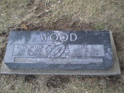
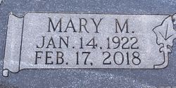
Minnie “Ruth” Taylor Wood
| Birth | : | 28 Dec 1913 Ogden, Riley County, Kansas, USA |
| Death | : | 13 Aug 2006 Jackson County, Kansas, USA |
| Burial | : | Mount Hope Cemetery, Enterprise, Dickinson County, USA |
| Coordinate | : | 38.8869019, -97.1121979 |
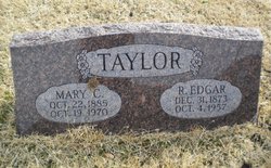
| Description | : | Mrs. Wood was born December 28, 1913 in Ogden, KS, the daughter of Richard Edgar and Mary Christina Smith Taylor. She graduated from Dwight High School in Dwight, KS and lived in Dwight until 1934. She lived in Enterprise, KS and later in Talmage, KS for many years. She had also lived in Valley Falls, KS for a short time and moved to Holton from Abilene in 1995. She was a homemaker. Mrs. Wood was a member of the First United Methodist Church in Abilene. She was married to Raymond L. Engle on June 1, 1935 in Enterprise, KS. They were... Read More |
frequently asked questions (FAQ):
-
Where is Minnie “Ruth” Taylor Wood's memorial?
Minnie “Ruth” Taylor Wood's memorial is located at: Mount Hope Cemetery, Enterprise, Dickinson County, USA.
-
When did Minnie “Ruth” Taylor Wood death?
Minnie “Ruth” Taylor Wood death on 13 Aug 2006 in Jackson County, Kansas, USA
-
Where are the coordinates of the Minnie “Ruth” Taylor Wood's memorial?
Latitude: 38.8869019
Longitude: -97.1121979
Family Members:
Parent
Spouse


Siblings
Children
Flowers:


Nearby Cemetories:
1. Mount Hope Cemetery
Enterprise, Dickinson County, USA
Coordinate: 38.8869019, -97.1121979
2. Scheiller Cemetery
Enterprise, Dickinson County, USA
Coordinate: 38.8669014, -97.1106033
3. Pleasant Hill Cemetery
Enterprise, Dickinson County, USA
Coordinate: 38.8885150, -97.0749560
4. Lutheran Cemetery #17
Enterprise, Dickinson County, USA
Coordinate: 38.9009209, -97.0734787
5. Detroit Cemetery
Detroit, Dickinson County, USA
Coordinate: 38.9439300, -97.1255100
6. Farmington Cemetery
Abilene, Dickinson County, USA
Coordinate: 38.8707800, -97.1860200
7. Brown Memorial Cemetery
Abilene, Dickinson County, USA
Coordinate: 38.8755950, -97.1993410
8. Eisenhower Presidential Library and Museum Chapel
Abilene, Dickinson County, USA
Coordinate: 38.9118450, -97.2129410
9. Saint John's Episcopal Church Memorial Garden
Abilene, Dickinson County, USA
Coordinate: 38.9202700, -97.2137300
10. Dwight D. Eisenhower Municipal Building
Abilene, Dickinson County, USA
Coordinate: 38.9191100, -97.2155700
11. Navarre Cemetery
Navarre, Dickinson County, USA
Coordinate: 38.7957115, -97.1080627
12. Riffel Cemetery (Defunct)
Woodbine, Dickinson County, USA
Coordinate: 38.8177986, -97.0342026
13. Abilene Cemetery
Abilene, Dickinson County, USA
Coordinate: 38.9322014, -97.2217026
14. Belle Springs Cemetery
Hope, Dickinson County, USA
Coordinate: 38.7907982, -97.1481018
15. Mount Saint Joseph Cemetery
Abilene, Dickinson County, USA
Coordinate: 38.9442170, -97.2218690
16. Indian Hill Cemetery
Chapman, Dickinson County, USA
Coordinate: 38.9714012, -97.0327988
17. Bethel Cemetery
Moonlight, Dickinson County, USA
Coordinate: 39.0022011, -97.1110535
18. Rinehart Cemetery
Enterprise, Dickinson County, USA
Coordinate: 38.9021988, -96.9638977
19. Saint Patricks Cemetery
Chapman, Dickinson County, USA
Coordinate: 38.9803330, -97.0062850
20. Newbern Cemetery
Holland, Dickinson County, USA
Coordinate: 38.8133011, -97.2427979
21. Ebenezer Baptist Cemetery
Dickinson County, USA
Coordinate: 38.7659569, -97.1696701
22. Langhofer Cemetery
Woodbine, Dickinson County, USA
Coordinate: 38.7905530, -96.9921110
23. Langhofer-Riffel Cemetery
Woodbine, Dickinson County, USA
Coordinate: 38.7835530, -96.9874660
24. Mount Zion Cemetery
Junction City, Geary County, USA
Coordinate: 38.8762000, -96.9267080