
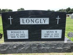
Mona M. Bauer Longly
| Birth | : | 4 Feb 1929 Litchfield, Sherman County, Nebraska, USA |
| Death | : | 25 May 2015 Lexington, Dawson County, Nebraska, USA |
| Burial | : | Saint Anns Cemetery, Lexington, Dawson County, USA |
| Coordinate | : | 40.7789001, -99.7114029 |
| Plot | : | DIV. A, LOT 67, SPACE 2. |
| Description | : | Mona M. Longly, 86, of Lexington, Nebraska, passed away Monday, May 25, 2015 at Park Avenue Estates in Lexington. She was born February 4, 1929, in Litchfield, Nebraska, to Charles and Erma (Cool) Bauer. Mona attended school in Sumner and graduated from Sumner High School with the class of 1946. She then went onto further her education at Kearney State Teacher’s College. She taught for two years, one year at District #49, from 1946-1947, and District N3, from 1947-1948. She worked arm in arm with Ron with their farming and cattle operation. Mona was united in marriage to Ronald E.... Read More |
frequently asked questions (FAQ):
-
Where is Mona M. Bauer Longly's memorial?
Mona M. Bauer Longly's memorial is located at: Saint Anns Cemetery, Lexington, Dawson County, USA.
-
When did Mona M. Bauer Longly death?
Mona M. Bauer Longly death on 25 May 2015 in Lexington, Dawson County, Nebraska, USA
-
Where are the coordinates of the Mona M. Bauer Longly's memorial?
Latitude: 40.7789001
Longitude: -99.7114029
Family Members:
Parent

Spouse

Siblings
Children
Flowers:


Nearby Cemetories:
1. Greenwood Cemetery
Lexington, Dawson County, USA
Coordinate: 40.7956467, -99.7286682
2. First United Methodist Church Columbarium
Lexington, Dawson County, USA
Coordinate: 40.7810000, -99.7397000
3. Evergreen Cemetery
Lexington, Dawson County, USA
Coordinate: 40.7639008, -99.6791992
4. Mount Hope Cemetery
Dawson County, USA
Coordinate: 40.8293991, -99.6733017
5. Hewitt Cemetery
Lexington, Dawson County, USA
Coordinate: 40.8588982, -99.7769012
6. Robb Cemetery
Smithfield, Gosper County, USA
Coordinate: 40.6710691, -99.6996001
7. Buffalo Grove Presbyterian Church Cemetery
Buffalo, Dawson County, USA
Coordinate: 40.8721000, -99.8270000
8. Hillside Cemetery
Dawson County, USA
Coordinate: 40.8946991, -99.7869034
9. Plum Creek Massacre Cemetery
Phelps County, USA
Coordinate: 40.6726840, -99.6058220
10. Grace Cemetery
Cozad, Dawson County, USA
Coordinate: 40.8602982, -99.8644028
11. Overton Cemetery
Overton, Dawson County, USA
Coordinate: 40.7317009, -99.5222015
12. Saint Johns Lutheran Cemetery
Lexington, Dawson County, USA
Coordinate: 40.9019012, -99.8458023
13. Quakerville Cemetery
Gosper County, USA
Coordinate: 40.6189003, -99.8097000
14. Adullam Cemetery
Bertrand, Phelps County, USA
Coordinate: 40.6265000, -99.5856000
15. Cozad Cemetery
Cozad, Dawson County, USA
Coordinate: 40.8605995, -99.9475021
16. Elwood Cemetery
Elwood, Gosper County, USA
Coordinate: 40.5999300, -99.8397300
17. Platte Valley Cemetery
Phelps County, USA
Coordinate: 40.6425018, -99.5028000
18. Keely Cemetery
Smithfield, Gosper County, USA
Coordinate: 40.5727500, -99.6563500
19. Saint Patricks Cemetery
Eddyville, Dawson County, USA
Coordinate: 40.9747009, -99.6093979
20. Sandstrom Cemetery
Phelps County, USA
Coordinate: 40.5983009, -99.5661011
21. Jewell Cemetery
Sumner, Dawson County, USA
Coordinate: 40.9599991, -99.5646973
22. Hope Lutheran Cemetery
Smithfield, Gosper County, USA
Coordinate: 40.5667500, -99.6800000
23. Fairview Cemetery
Dawson County, USA
Coordinate: 40.7719002, -99.9955978
24. Cottonwood Cemetery
Dawson County, USA
Coordinate: 40.9322014, -99.9197006