
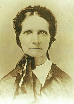
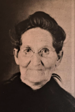
Mrs Rhoda Ann Markwell Cain
| Birth | : | 28 Oct 1846 USA |
| Death | : | 5 Apr 1928 Maryville, Nodaway County, Missouri, USA |
| Burial | : | Nara Visa Cemetery, Nara Visa, Quay County, USA |
| Coordinate | : | 35.6064900, -103.1161400 |
| Plot | : | Sec 4, Lot 208, Row 14, South, This is an UNMARKED GRAVE. |
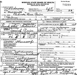
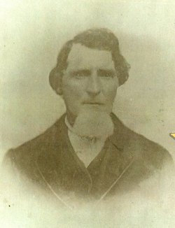
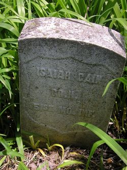
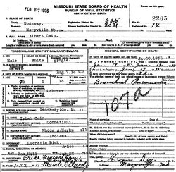
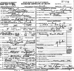
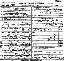
| Description | : | 82y 5m 8d. Wife of Isaiah Cain, married 9 Jun 1861 Nodaway Co., MO. Mother of Lucretia, Lemuel, Albert, Alonzo and Clara Cain. Daughter of Hiram and Sarah (Naugle) Markwell. |
frequently asked questions (FAQ):
-
Where is Mrs Rhoda Ann Markwell Cain's memorial?
Mrs Rhoda Ann Markwell Cain's memorial is located at: Nara Visa Cemetery, Nara Visa, Quay County, USA.
-
When did Mrs Rhoda Ann Markwell Cain death?
Mrs Rhoda Ann Markwell Cain death on 5 Apr 1928 in Maryville, Nodaway County, Missouri, USA
-
Where are the coordinates of the Mrs Rhoda Ann Markwell Cain's memorial?
Latitude: 35.6064900
Longitude: -103.1161400
Family Members:
Parent
Spouse
Siblings

Children
Flowers:


Nearby Cemetories:
1. Nara Visa Cemetery
Nara Visa, Quay County, USA
Coordinate: 35.6064900, -103.1161400
2. Independent Order of Odd Fellows Cemetery
Nara Visa, Quay County, USA
Coordinate: 35.6158400, -103.1076100
3. Obar Cemetery
Obar, Quay County, USA
Coordinate: 35.5200005, -103.2027969
4. Obar Cemetery
Amistad, Union County, USA
Coordinate: 35.5200900, -103.2032700
5. Rowe Cemetery
Quay County, USA
Coordinate: 35.6528850, -103.3075550
6. Cherokee Valley Cemetery
Quay County, USA
Coordinate: 35.6530991, -103.3285980
7. Centerville Cemetery
Centerville, Union County, USA
Coordinate: 35.7980000, -103.0986000
8. Fairview Cemetery
Amistad, Union County, USA
Coordinate: 35.8233810, -103.1616210
9. Fairmount Cemetery
Union County, USA
Coordinate: 35.8236008, -103.1607971
10. Amistad Cemetery
Amistad, Union County, USA
Coordinate: 35.9077988, -103.1769028
11. Logan Cemetery
Logan, Quay County, USA
Coordinate: 35.3774986, -103.3858032
12. Rana Cemetery
Quay County, USA
Coordinate: 35.2999600, -103.2768900
13. Rosebud Cemetery
Harding County, USA
Coordinate: 35.8319016, -103.4638977
14. Vigil Cemetery
Harding County, USA
Coordinate: 35.4143982, -103.5192032
15. Hayden Cemetery
Hayden, Union County, USA
Coordinate: 35.9658000, -103.2708000
16. Holy Trinity Catholic Cemetery
Hayden, Union County, USA
Coordinate: 35.9694000, -103.2695000
17. Anniston Cemetery
Quay County, USA
Coordinate: 35.2571983, -103.3218994
18. Genova Cemetery
Harding County, USA
Coordinate: 35.5395900, -103.5927900
19. Alamosa Cemetery
Harding County, USA
Coordinate: 35.4502983, -103.5706024
20. Cejita Cemetery
Harding County, USA
Coordinate: 35.8274994, -103.5864029
21. Maytum Cemetery
Harding County, USA
Coordinate: 35.9439011, -103.4950027
22. Endee Cemetery
Quay County, USA
Coordinate: 35.1453018, -103.1247025
23. Pedernal Cemetery
Hayden, Union County, USA
Coordinate: 36.0174800, -103.4244100
24. Pedernal Cemetery
Harding County, USA
Coordinate: 36.0175018, -103.4246979