

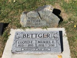
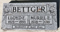
Muriel Elsie Borley Bettger
| Birth | : | 1 Mar 1928 Swan River, Swan River Census Division, Manitoba, Canada |
| Death | : | 2 Mar 2018 |
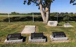
| Burial | : | Magrath Cemetery, Magrath, Claresholm Census Division, Canada |
| Coordinate | : | 49.3985700, -112.8648700 |
| Plot | : | Block 1 Plot 12 Grave 4 |
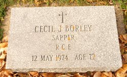
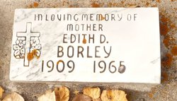
| Description | : | SALMON & SONS - obit excerpts MURIEL ELSIE (BORLEY) BETTGER returned to her heavenly home to be reunited with her eternal husband, Lloyd, on March 2, 2018. She was a devoted daughter of the Lord dedicated to her family and the gospel teachings of the LDS Church. Muriel was born to Cecil and Edith Borley on March 1, 1928, in Swan River, Manitoba. She moved with her family to British Columbia where she met and fell in love with Lloyd Bettger. They were married on May 17, 1946, and they were blessed with nine children. She loved... Read More |
frequently asked questions (FAQ):
-
Where is Muriel Elsie Borley Bettger's memorial?
Muriel Elsie Borley Bettger's memorial is located at: Magrath Cemetery, Magrath, Claresholm Census Division, Canada.
-
When did Muriel Elsie Borley Bettger death?
Muriel Elsie Borley Bettger death on 2 Mar 2018 in
-
Where are the coordinates of the Muriel Elsie Borley Bettger's memorial?
Latitude: 49.3985700
Longitude: -112.8648700
Family Members:
Parent
Spouse
Siblings
Children
Flowers:


Nearby Cemetories:
1. Magrath Cemetery
Magrath, Claresholm Census Division, Canada
Coordinate: 49.3985700, -112.8648700
2. Hutterville Hutterite Cemetery
Magrath, Claresholm Census Division, Canada
Coordinate: 49.3503165, -112.7701038
3. Rockport Colony Cemetery
Magrath, Claresholm Census Division, Canada
Coordinate: 49.3027780, -112.8136110
4. Spring Valley Hutterite Colony Cemetery
Spring Coulee, Claresholm Census Division, Canada
Coordinate: 49.3517043, -113.0551519
5. Spring Coulee Cemetery
Spring Coulee, Claresholm Census Division, Canada
Coordinate: 49.3412100, -113.0541400
6. Temple Hill Cemetery
Raymond, Lethbridge Census Division, Canada
Coordinate: 49.4916300, -112.6605200
7. East Raymond Hutterite Colony Cemetery
Raymond, Lethbridge Census Division, Canada
Coordinate: 49.4185305, -112.5791329
8. Stirling Mennonite Church Cemetery
Stirling, Lethbridge Census Division, Canada
Coordinate: 49.4607570, -112.5387970
9. Wolf Creek Hutterite Colony Cemetery
Stirling, Lethbridge Census Division, Canada
Coordinate: 49.4119142, -112.5163705
10. Crystal Spring Hutterite Colony Cemetery
Magrath, Claresholm Census Division, Canada
Coordinate: 49.1702490, -112.8048290
11. Stirling Cemetery
Stirling, Lethbridge Census Division, Canada
Coordinate: 49.5093400, -112.5380000
12. West Raley Hutterite Cemetery
Raley, Claresholm Census Division, Canada
Coordinate: 49.2908857, -113.2283616
13. Mountain View Cemetery
Lethbridge, Lethbridge Census Division, Canada
Coordinate: 49.6800385, -112.8297729
14. Woolford Cemetery
Woolford, Claresholm Census Division, Canada
Coordinate: 49.1945800, -113.1652300
15. Wilson Siding Hutterite Cemetery
Wilson, Lethbridge Census Division, Canada
Coordinate: 49.6203914, -112.5781130
16. Indian Battle Park
Lethbridge, Lethbridge Census Division, Canada
Coordinate: 49.6928200, -112.8582900
17. Saint Catherine Cemetery
Stand Off, Claresholm Census Division, Canada
Coordinate: 49.4516900, -113.3112300
18. Big Bend Hutterite Colony
Cardston, Claresholm Census Division, Canada
Coordinate: 49.1636110, -113.1411110
19. Standoff Hutterite Colony Cemetery
Stand Off, Claresholm Census Division, Canada
Coordinate: 49.4829507, -113.3130885
20. Archmount Cemetery
Lethbridge, Lethbridge Census Division, Canada
Coordinate: 49.7057900, -112.9017500
21. Saint Patrick's Cemetery
Lethbridge, Lethbridge Census Division, Canada
Coordinate: 49.7084618, -112.8428726
22. East Cardston Hutterite Cemetery
Cardston, Claresholm Census Division, Canada
Coordinate: 49.1908348, -113.2258004
23. New Dayton Community Cemetery
New Dayton, Lethbridge Census Division, Canada
Coordinate: 49.4254300, -112.3601800
24. Royal View Memorial Cemetery
Lethbridge, Lethbridge Census Division, Canada
Coordinate: 49.7518540, -112.8242250