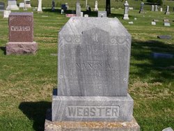
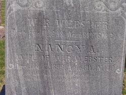
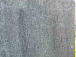
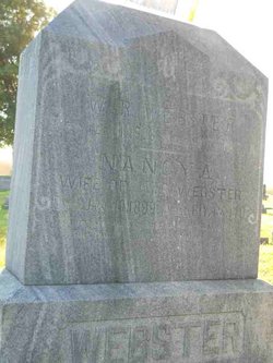
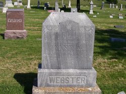
Nancy A. Collins Webster
| Birth | : | 5 Dec 1817 Greene County, Tennessee, USA |
| Death | : | 19 Jan 1899 Jackson County, Kansas, USA |
| Burial | : | Volksrust Cemetery, Volksrust, Gert Sibande District Municipality, South Africa |
| Coordinate | : | -27.3771582, 29.8516815 |
| Plot | : | SECTION 3 |
| Inscription | : | AGED 81Y, 1M, 14D |
| Description | : | Nancy Collins was born in Green county, East Tennessee, December 5, 1817, and died at her home in this county, January 19, 1899, aged 81 years, 1 month and 2 days. The deceased with her parents moved to Randolph county, Ind., in 1821 where she grew to womanhood, and where, November 15, 1836, over sixty-two years ago she married her now bereaved husband W. R. Webster. When but fourteen years of age she joined the Methodist church ... Mrs. Webster was the mother of nine children, four of whom are still living: E. C. is in Los Angles, Cal., and... Read More |
frequently asked questions (FAQ):
-
Where is Nancy A. Collins Webster's memorial?
Nancy A. Collins Webster's memorial is located at: Volksrust Cemetery, Volksrust, Gert Sibande District Municipality, South Africa.
-
When did Nancy A. Collins Webster death?
Nancy A. Collins Webster death on 19 Jan 1899 in Jackson County, Kansas, USA
-
Where are the coordinates of the Nancy A. Collins Webster's memorial?
Latitude: -27.3771582
Longitude: 29.8516815
Family Members:
Spouse
Children
Flowers:
Nearby Cemetories:
1. Volksrust Cemetery
Volksrust, Gert Sibande District Municipality, South Africa
Coordinate: -27.3771582, 29.8516815
2. Charlestown Cemetery
Charlestown, Amajuba District Municipality, South Africa
Coordinate: -27.4106100, 29.8834900
3. Wakkerstroom Cemetery
Mpumalanga, eThekwini Metropolitan Municipality, South Africa
Coordinate: -27.3593249, 30.1346429
4. Wakkerstroom Cemetery
Wakkerstroom, Gert Sibande District Municipality, South Africa
Coordinate: -27.3590287, 30.1351685
5. Oosthuizen Family Cemetery
Amersfoort (Pixley Ka Seme), Gert Sibande District Municipality, South Africa
Coordinate: -27.0281330, 29.9017830
6. Amersfoort New Cemetery
Amersfoort (Pixley Ka Seme), Gert Sibande District Municipality, South Africa
Coordinate: -27.0137830, 29.8457830
7. Amersfoort Old Cemetery
Amersfoort (Pixley Ka Seme), Gert Sibande District Municipality, South Africa
Coordinate: -27.0124100, 29.8698100
8. NG Kerk - Bergsig Newcastle Muur van Herinnering
Hutton Heights, Amajuba District Municipality, South Africa
Coordinate: -27.7370730, 29.9267400
9. Schulpspruit 60 HS 2 farm cemetery
Amersfoort (Pixley Ka Seme), Gert Sibande District Municipality, South Africa
Coordinate: -27.0053490, 29.8814430
10. Hardwick Street Cemetery
Newcastle, Amajuba District Municipality, South Africa
Coordinate: -27.7566224, 29.9443700
11. Falkirk Street Cemetery
Newcastle, Amajuba District Municipality, South Africa
Coordinate: -27.7577900, 29.9470700
12. NG Kerk - Memel Kerkhof en Gedenkmuur
Memel, Thabo Mofutsanyana District Municipality, South Africa
Coordinate: -27.6778330, 29.5683170
13. Memel Cemetery
Memel, Thabo Mofutsanyana District Municipality, South Africa
Coordinate: -27.6887170, 29.5617830
14. Roy Point Cemetery
Amajuba District Municipality, South Africa
Coordinate: -27.7863620, 29.9844830
15. Hartebeestfontein 524 farm cemetery
Amersfoort (Pixley Ka Seme), Gert Sibande District Municipality, South Africa
Coordinate: -26.9410830, 29.6775170
16. Blaauwbosch Cemetery
Blaauwbosch, Amajuba District Municipality, South Africa
Coordinate: -27.7819470, 30.1076130
17. NG Kerk - Vrede Muur van Herinnering
Vrede, Thabo Mofutsanyana District Municipality, South Africa
Coordinate: -27.4262950, 29.1635350
18. AP Kerk - Vrede Muur van Herinnering
Vrede, Thabo Mofutsanyana District Municipality, South Africa
Coordinate: -27.4330330, 29.1638170
19. Baltrasna 339 farm cemetery
Gert Sibande District Municipality, South Africa
Coordinate: -26.8582330, 30.2276170
20. NG Kerk - Vrede - Wes Muur van Herinnering
Vrede, Thabo Mofutsanyana District Municipality, South Africa
Coordinate: -27.4357770, 29.1561480
21. Meyerville Cemetery
Meyerville, Gert Sibande District Municipality, South Africa
Coordinate: -26.9668800, 29.2562500
22. Peter-Paul Kirche Lutheran Cemetery
Paulpietersburg, Zululand District Municipality, South Africa
Coordinate: -27.3144970, 30.6199030
23. Ntombi Cemetery
Zululand District Municipality, South Africa
Coordinate: -27.2325000, 30.6113890
24. Talana Cemetery
Dundee, uMzinyathi District Municipality, South Africa
Coordinate: -28.0921600, 30.1535500

