
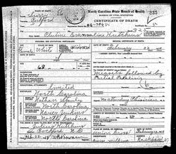
| Birth | : | 25 Aug 1875 Surry County, North Carolina, USA |
| Death | : | 4 Nov 1948 Surry County, North Carolina, USA |
| Burial | : | Rotorua Crematorium and Cemetery, Rotorua, Rotorua District, New Zealand |
| Coordinate | : | -38.1533100, 176.2630900 |
| Description | : | Maternal grandparents were Hiram Jenkins, Sr. and Nancy Marsh Jenkins. Henry was a farmer in Marsh Township, Surry County, North Carolina. He and his family were members of Mount Pleasant Baptist Church in Jenkinstown, Surry County, North Carolina. He and his wife "Lou" are buried in unmarked graves in that church cemetery. In the 1900 census of Surry County it is stated that this couple had had two children with only one living. Unfortunately that one child was not named, nor was its gender or age given. It is unknown at this time where Rhoda and Wilhilminna May were residing. (Recorded by:... Read More |
frequently asked questions (FAQ):
-
Where is Nancy Louisa “Lou” Stanley Bates's memorial?
Nancy Louisa “Lou” Stanley Bates's memorial is located at: Rotorua Crematorium and Cemetery, Rotorua, Rotorua District, New Zealand.
-
When did Nancy Louisa “Lou” Stanley Bates death?
Nancy Louisa “Lou” Stanley Bates death on 4 Nov 1948 in Surry County, North Carolina, USA
-
Where are the coordinates of the Nancy Louisa “Lou” Stanley Bates's memorial?
Latitude: -38.1533100
Longitude: 176.2630900
Family Members:
Parent

Spouse
Siblings
Children
Flowers:


Nearby Cemetories:
1. Rotorua Crematorium and Cemetery
Rotorua, Rotorua District, New Zealand
Coordinate: -38.1533100, 176.2630900
2. Whakarewarewa Urupā
Rotorua, Rotorua District, New Zealand
Coordinate: -38.1629708, 176.2556791
3. Kauae Cemetery
Ngongotaha, Rotorua District, New Zealand
Coordinate: -38.0915298, 176.2152557
4. Waiteti (Weriwiri Pa) Cemetery
Ngongotaha, Rotorua District, New Zealand
Coordinate: -38.0689500, 176.2132000
5. Ruamano Parekarangi Urupā
Horohoro, Rotorua District, New Zealand
Coordinate: -38.2349430, 176.1912227
6. Puhirua Urupā
Ngongotaha, Rotorua District, New Zealand
Coordinate: -38.0433300, 176.2228820
7. Motutawa Māori Cemetery
Mourea, Rotorua District, New Zealand
Coordinate: -38.0458300, 176.3381400
8. Okere Māori Cemetery
Okere Falls, Rotorua District, New Zealand
Coordinate: -38.0332900, 176.3464800
9. Mamaku Cemetery
Mamaku, Rotorua District, New Zealand
Coordinate: -38.0986200, 176.0726700
10. Ngāti Tarāwhai Ruatō urupa
Rotoiti, Rotorua District, New Zealand
Coordinate: -38.0578310, 176.4334750
11. Punawhakareia Urupa
Rotoiti, Rotorua District, New Zealand
Coordinate: -38.0566969, 176.4451150
12. Ngakuru Cemetery
Rotorua, Rotorua District, New Zealand
Coordinate: -38.3227770, 176.1911950
13. Tokoroa Cemetery
Tokoroa, South Waikato District, New Zealand
Coordinate: -38.2311010, 175.8826160
14. Kawerau Cemetery
Kawerau, Kawerau District, New Zealand
Coordinate: -38.0990990, 176.6762150
15. Te Puke Cemetery
Te Puke, Western Bay of Plenty District, New Zealand
Coordinate: -37.8054430, 176.3078800
16. Old Te Puke Cemetery
Te Puke, Western Bay of Plenty District, New Zealand
Coordinate: -37.7884910, 176.3354700
17. Te Kahika Māori Cemetery
Te Puke, Western Bay of Plenty District, New Zealand
Coordinate: -37.7884600, 176.3445600
18. Domain Road Cemetery
Putaruru, South Waikato District, New Zealand
Coordinate: -38.0603810, 175.7952220
19. Tirau Sreet Cemetery
Putaruru, South Waikato District, New Zealand
Coordinate: -38.0431570, 175.7834490
20. Pyes Pa Memorial Park
Tauranga, Tauranga City, New Zealand
Coordinate: -37.7689800, 176.1162770
21. Maketu Cemetery
Maketu, Western Bay of Plenty District, New Zealand
Coordinate: -37.7634700, 176.4511500
22. St. Thomas's Anglican Churchyard
Maketu, Western Bay of Plenty District, New Zealand
Coordinate: -37.7600849, 176.4555692
23. Tirau Cemetery
Tirau, South Waikato District, New Zealand
Coordinate: -37.9622060, 175.7796770
24. Hairini
Hairini, Tauranga City, New Zealand
Coordinate: -37.7241530, 176.1656207