
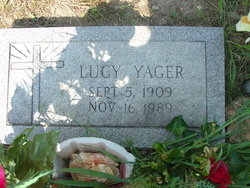
Nancy Lucinda “Lucy” Lamborn Yager
| Birth | : | 5 Sep 1909 Eminence, Shannon County, Missouri, USA |
| Death | : | 16 Nov 1989 Ellington, Reynolds County, Missouri, USA |
| Burial | : | Sunny Slope Cemetery, West Point, King William County, USA |
| Coordinate | : | 37.5477982, -76.8031006 |
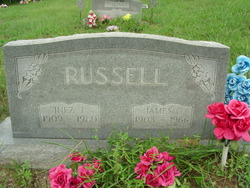
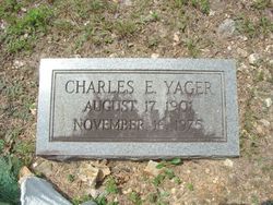
| Description | : | Lucy Yager daughter of the late John Wesley Lamborn and Mae Busby Lamborn was born on Sinkin Creek near Eminence, on Sept. 5, 1909. She departed this life at the Reynolds County Memorial Hospital in Ellington, on Nov. 16, 1989 having attained the age of 80 years 2 months and 11 days. At Van Buren in 1928 she was united in marriage to James Russell. In 1939 she was united in marriage to Charles Yager, both of her husbands preceded Lucy in death. Lucy moved to the Ellington area in 1963 coming here from Winona. She... Read More |
frequently asked questions (FAQ):
-
Where is Nancy Lucinda “Lucy” Lamborn Yager's memorial?
Nancy Lucinda “Lucy” Lamborn Yager's memorial is located at: Sunny Slope Cemetery, West Point, King William County, USA.
-
When did Nancy Lucinda “Lucy” Lamborn Yager death?
Nancy Lucinda “Lucy” Lamborn Yager death on 16 Nov 1989 in Ellington, Reynolds County, Missouri, USA
-
Where are the coordinates of the Nancy Lucinda “Lucy” Lamborn Yager's memorial?
Latitude: 37.5477982
Longitude: -76.8031006
Family Members:
Parent
Spouse
Children

Flowers:


Nearby Cemetories:
1. Sunny Slope Cemetery
West Point, King William County, USA
Coordinate: 37.5477982, -76.8031006
2. Saint Theresas Cemetery
West Point, King William County, USA
Coordinate: 37.5466995, -76.8032990
3. Pamunkey Neck Chapel Cemetery
West Point, King William County, USA
Coordinate: 37.5300962, -76.7955810
4. Saint Luke's Baptist Church Cemetery
New Kent County, USA
Coordinate: 37.5200700, -76.8193130
5. Dixon Cemetery
Mattaponi, King and Queen County, USA
Coordinate: 37.5801570, -76.7693140
6. Ephesus Baptist Church Cemetery
West Point, King William County, USA
Coordinate: 37.5790700, -76.8454120
7. Oliver Russell Cemetery
Eltham, New Kent County, USA
Coordinate: 37.4993100, -76.8087500
8. Poroporone Baptist Church Cemetery
Shacklefords, King and Queen County, USA
Coordinate: 37.5514890, -76.7337300
9. Wahrani African-American Burial Ground
Barhamsville, New Kent County, USA
Coordinate: 37.5008230, -76.8502090
10. Warreneye Church Cemetery
Walkers, New Kent County, USA
Coordinate: 37.5001830, -76.8494500
11. Old Church United Methodist Church Cemetery
Shanghai, King and Queen County, USA
Coordinate: 37.6025320, -76.7704280
12. Olivet Baptist Church Cemetery
Shanghai, King and Queen County, USA
Coordinate: 37.6052130, -76.7752000
13. First Baptist Church Cemetery
Shacklefords, King and Queen County, USA
Coordinate: 37.5072460, -76.7377920
14. Saint John of Kanti Cemetery
Barhamsville, New Kent County, USA
Coordinate: 37.4881400, -76.8420300
15. Hrubienski Family Cemetery
Barhamsville, New Kent County, USA
Coordinate: 37.4958200, -76.8568500
16. Mount Olive Baptist Church Cemetery
Barhamsville, New Kent County, USA
Coordinate: 37.4770830, -76.7909470
17. Appleton Farm Cemetery
New Kent County, USA
Coordinate: 37.4809420, -76.8375590
18. Mount Nebo Baptist Church Cemetery
Barhamsville, New Kent County, USA
Coordinate: 37.4822070, -76.8420460
19. Eames Family Cemetery
New Kent County, USA
Coordinate: 37.5168953, -76.8864136
20. Angel View Baptist Church Cemetery
Lanexa, New Kent County, USA
Coordinate: 37.5023230, -76.8752810
21. Escobrook Baptist Church Cemetery
Mattaponi, King and Queen County, USA
Coordinate: 37.5947980, -76.7298300
22. Second Elam Baptist Church Cemetery
Lanexa, New Kent County, USA
Coordinate: 37.5225650, -76.8999570
23. Sweet Hall Cemetery
King William County, USA
Coordinate: 37.5700360, -76.9037120
24. Burton Cemetery
Mascot, King and Queen County, USA
Coordinate: 37.6084490, -76.7299050