

Nanna Bell “Nannie” Brown Johns
| Birth | : | 24 Jan 1917 Pittsburg, Crawford County, Kansas, USA |
| Death | : | 25 Mar 1992 Arcadia, Crawford County, Kansas, USA |
| Burial | : | Crown Hill Cemetery, Centerville, Wayne County, USA |
| Coordinate | : | 39.8231010, -84.9991989 |
| Plot | : | Block 7, Section E1/2, Lot 212, Space # 4 |
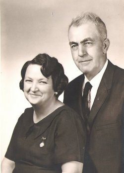
| Description | : | Nannie Johns Nannie Johns, 75, of 2309 N. Rouse, died at 9 p.m. Wednesday, March 25, 1992, at the home of her son James "Jim' Johns, in Arcadia. She had been ill for the past six months. Mrs. Johns was born January 24, 1917 at Pittsburg to William H. and Sofronia (Neff) Brown. She lived her entire life in Pittsburg and was a member of the Presbyterian Church. She married Henry "Hank" Johns on June 11, 1930, at Nevada, MO. He preceded her in death on May 28, 1977. Survivors include three sons, William H.... Read More |
frequently asked questions (FAQ):
-
Where is Nanna Bell “Nannie” Brown Johns's memorial?
Nanna Bell “Nannie” Brown Johns's memorial is located at: Crown Hill Cemetery, Centerville, Wayne County, USA.
-
When did Nanna Bell “Nannie” Brown Johns death?
Nanna Bell “Nannie” Brown Johns death on 25 Mar 1992 in Arcadia, Crawford County, Kansas, USA
-
Where are the coordinates of the Nanna Bell “Nannie” Brown Johns's memorial?
Latitude: 39.8231010
Longitude: -84.9991989
Family Members:
Parent
Spouse

Siblings
Children

Flowers:


Nearby Cemetories:
1. Crown Hill Cemetery
Centerville, Wayne County, USA
Coordinate: 39.8231010, -84.9991989
2. Old Centerville Cemetery
Centerville, Wayne County, USA
Coordinate: 39.8205190, -84.9976160
3. Wayne County Poor Farm Cemetery
Center Township, Wayne County, USA
Coordinate: 39.8181810, -85.0282810
4. West Grove Cemetery
Centerville, Wayne County, USA
Coordinate: 39.8438988, -85.0141983
5. Bryan Cemetery
Centerville, Wayne County, USA
Coordinate: 39.7942000, -85.0253000
6. East Haven Cemetery
Richmond, Wayne County, USA
Coordinate: 39.8420330, -84.9367550
7. Olive Hill Cemetery
Greens Fork, Wayne County, USA
Coordinate: 39.8745620, -84.9922190
8. Kepler Cemetery
Jacksonburg, Wayne County, USA
Coordinate: 39.8528350, -85.0641750
9. United Brethren Church Cemetery
Wayne County, USA
Coordinate: 39.7977982, -85.0693970
10. Earlham Cemetery
Richmond, Wayne County, USA
Coordinate: 39.8258220, -84.9171020
11. King Cemetery
Richmond, Wayne County, USA
Coordinate: 39.8468800, -84.9228600
12. Pet Haven Cemetery
Greens Fork, Wayne County, USA
Coordinate: 39.8911100, -85.0338620
13. Stevens Family Cemetery
Abington, Wayne County, USA
Coordinate: 39.7500191, -84.9964905
14. Greens Fork Cemetery
Greens Fork, Wayne County, USA
Coordinate: 39.8871994, -85.0453033
15. Lutherania Cemetery
Richmond, Wayne County, USA
Coordinate: 39.8017006, -84.9077988
16. Null Family Cemetery
Greens Fork, Wayne County, USA
Coordinate: 39.8602000, -85.0830000
17. Saint Andrew Cemetery
Richmond, Wayne County, USA
Coordinate: 39.8060989, -84.9036026
18. Saint Paul's Episcopal Church Columbarium
Richmond, Wayne County, USA
Coordinate: 39.8309430, -84.8911570
19. Willits Cemetery
West Grove, Wayne County, USA
Coordinate: 39.8240790, -85.1083610
20. Locust Grove Methodist Episcopal Cemetery
Locust Grove, Wayne County, USA
Coordinate: 39.7411003, -84.9736023
21. Doddridge Chapel Cemetery
Centerville, Wayne County, USA
Coordinate: 39.7508011, -85.0560989
22. Fairfield Cemetery
Greens Fork, Wayne County, USA
Coordinate: 39.9035988, -85.0344009
23. Whitewater Friends Burial Ground Hicksite
Richmond, Wayne County, USA
Coordinate: 39.8366300, -84.8894100
24. Whitewater Friends Burial Ground Orthodox
Richmond, Wayne County, USA
Coordinate: 39.8370000, -84.8889300