

Nannie F Raikes Bagby
| Birth | : | 1873 Buckingham County, Virginia, USA |
| Death | : | 1959 Nottoway County, Virginia, USA |
| Burial | : | Hartman Cemetery, Hartman, Johnson County, USA |
| Coordinate | : | 35.4253006, -93.6175003 |
| Plot | : | Block H lot 20 |
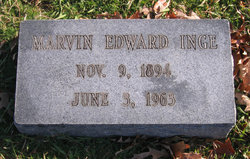
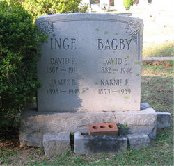
| Description | : | Nannie first married David P. Inge during 1892. Widowed, Nannie then married David E. Bagby on October 12, 1913 in Nottoway County, Virginia |
frequently asked questions (FAQ):
-
Where is Nannie F Raikes Bagby's memorial?
Nannie F Raikes Bagby's memorial is located at: Hartman Cemetery, Hartman, Johnson County, USA.
-
When did Nannie F Raikes Bagby death?
Nannie F Raikes Bagby death on 1959 in Nottoway County, Virginia, USA
-
Where are the coordinates of the Nannie F Raikes Bagby's memorial?
Latitude: 35.4253006
Longitude: -93.6175003
Family Members:
Parent
Spouse

Children
Flowers:


Nearby Cemetories:
1. Hartman Cemetery
Hartman, Johnson County, USA
Coordinate: 35.4253006, -93.6175003
2. Sacred Heart Cemetery
Hartman, Johnson County, USA
Coordinate: 35.4537500, -93.6018870
3. Huddleston Cemetery
Coal Hill, Johnson County, USA
Coordinate: 35.4411011, -93.6588974
4. Hess Cemetery
Coal Hill, Johnson County, USA
Coordinate: 35.4500008, -93.6521988
5. Srygley Cemetery
Coal Hill, Johnson County, USA
Coordinate: 35.4406013, -93.6596985
6. West Mount Zion Cemetery
Hartman, Johnson County, USA
Coordinate: 35.4605820, -93.5913580
7. West Cemetery
Coal Hill, Johnson County, USA
Coordinate: 35.4197006, -93.6735992
8. Steel Cemetery
Clarksville, Johnson County, USA
Coordinate: 35.4761890, -93.6272910
9. Coal Hill Cemetery
Coal Hill, Johnson County, USA
Coordinate: 35.4357986, -93.6821976
10. Hays Chapel Cemetery
Clarksville, Johnson County, USA
Coordinate: 35.4470444, -93.5504837
11. Possum Walk Cemetery
Coal Hill, Johnson County, USA
Coordinate: 35.4771996, -93.6580963
12. Blair Cemetery
Scranton, Logan County, USA
Coordinate: 35.3732986, -93.5744019
13. Union Grove Cemetery
Clarksville, Johnson County, USA
Coordinate: 35.4767050, -93.5639190
14. Kendall Cemetery
Hartman, Johnson County, USA
Coordinate: 35.4956017, -93.6207962
15. Hardgraves Cemetery
Johnson County, USA
Coordinate: 35.5013000, -93.6345000
16. McKendree Cemetery
Subiaco, Logan County, USA
Coordinate: 35.3463500, -93.6312810
17. Ragon Cemetery
Logan County, USA
Coordinate: 35.3896750, -93.5269240
18. Saints Peter and Paul Catholic Cemetery
Morrison Bluff, Logan County, USA
Coordinate: 35.3869019, -93.5286026
19. Pleasant Grove Cemetery
Logan County, USA
Coordinate: 35.3400002, -93.6010971
20. Burnett Cemetery
Franklin County, USA
Coordinate: 35.4816100, -93.7066500
21. Spadra Cemetery
Spadra, Johnson County, USA
Coordinate: 35.4281006, -93.5018997
22. Houston Cemetery
Alix, Franklin County, USA
Coordinate: 35.4401500, -93.7343100
23. Bethlehem Cemetery
Hartman, Johnson County, USA
Coordinate: 35.5223920, -93.5945380
24. Saint Ignatius Cemetery
Scranton, Logan County, USA
Coordinate: 35.3591995, -93.5271988