

Neil Richard Henderly
| Birth | : | 31 Mar 1933 Lancaster, Fairfield County, Ohio, USA |
| Death | : | 1 Mar 2006 Canal Winchester, Franklin County, Ohio, USA |
| Burial | : | Strawberry Point Cemetery, Strawberry Point, Clayton County, USA |
| Coordinate | : | 42.6813800, -91.5236100 |
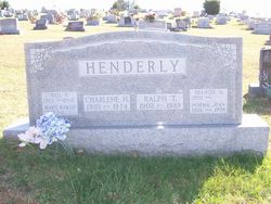
| Description | : | Columbus Dispatch, The (OH) - March 3, 2006 HENDERLY Neil Richard Henderly, 72, of Lancaster, passed away Wednesday, March 1, 2006 at Winchester Place Nursing Center in Canal Winchester after a lengthy illness with Alzheimer's disease. He was born on March 31, 1933, in Lancaster, the son of the late Ralph and Charlene Henderly. He was a dairy and grain farmer for 31 years and retired from the Fairfield County Engineer's Office as county road superintendent. He was president and valedictorian of the class of 1951 at Amanda High School. He was a past member of the Fairfield County Farm Bureau... Read More |
frequently asked questions (FAQ):
-
Where is Neil Richard Henderly's memorial?
Neil Richard Henderly's memorial is located at: Strawberry Point Cemetery, Strawberry Point, Clayton County, USA.
-
When did Neil Richard Henderly death?
Neil Richard Henderly death on 1 Mar 2006 in Canal Winchester, Franklin County, Ohio, USA
-
Where are the coordinates of the Neil Richard Henderly's memorial?
Latitude: 42.6813800
Longitude: -91.5236100
Family Members:
Parent

Spouse

Siblings
Flowers:


Nearby Cemetories:
1. Strawberry Point Cemetery
Strawberry Point, Clayton County, USA
Coordinate: 42.6813800, -91.5236100
2. Noble Cemetery
Edgewood, Clayton County, USA
Coordinate: 42.6735992, -91.4471970
3. Saint Sebald Lutheran Church Cemetery
Saint Sebald, Clayton County, USA
Coordinate: 42.7386000, -91.5460000
4. County Corners Cemetery
Cass Township, Clayton County, USA
Coordinate: 42.6441994, -91.6055984
5. Ross Cemetery
Clayton County, USA
Coordinate: 42.7528000, -91.4933014
6. Green Hill Cemetery
Edgewood, Clayton County, USA
Coordinate: 42.6739006, -91.4207993
7. Sacred Heart Cemetery
Clayton County, USA
Coordinate: 42.7542000, -91.4916992
8. Reed Cemetery
Clayton County, USA
Coordinate: 42.7353000, -91.6052000
9. Forestville Cemetery
Delaware County, USA
Coordinate: 42.5999985, -91.5286026
10. Pleasant Valley Cemetery
Richland Township, Delaware County, USA
Coordinate: 42.5999985, -91.4989014
11. Garretson Cemetery
Volga, Clayton County, USA
Coordinate: 42.7422100, -91.6067580
12. Saint Albert Cemetery
Dundee, Delaware County, USA
Coordinate: 42.6046982, -91.5877991
13. Saint Marks Cemetery
Edgewood, Delaware County, USA
Coordinate: 42.6372660, -91.3887830
14. Spring Hill Cemetery
Dundee, Delaware County, USA
Coordinate: 42.5744019, -91.5524979
15. Edgewood Cemetery
Edgewood, Delaware County, USA
Coordinate: 42.6366997, -91.3871994
16. Campton Cemetery
Lamont, Buchanan County, USA
Coordinate: 42.5924988, -91.6141968
17. Mederville Cemetery
Elkader, Clayton County, USA
Coordinate: 42.7638893, -91.4194412
18. Watkins Cemetery
Osborne, Clayton County, USA
Coordinate: 42.7833180, -91.4584733
19. Madison Cemetery
Lamont, Buchanan County, USA
Coordinate: 42.6028200, -91.6447650
20. Reynolds Cemetery
Dundee, Delaware County, USA
Coordinate: 42.5624851, -91.5418163
21. Old Stone School Cemetery
Volga, Clayton County, USA
Coordinate: 42.7973000, -91.5661000
22. Union Cemetery
Littleport, Clayton County, USA
Coordinate: 42.7388992, -91.3780975
23. Stranger Farm Cemetery
Delaware County, USA
Coordinate: 42.5694293, -91.5932088
24. Thorpe Union Cemetery
Delaware County, USA
Coordinate: 42.5639000, -91.4700012