
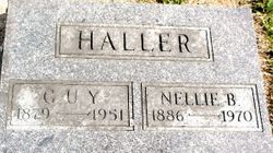
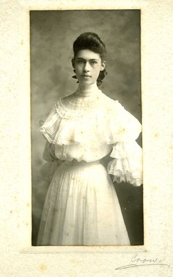

Nellie B. “Nell” Brackin Haller
| Birth | : | 5 Aug 1886 Maryville, Nodaway County, Missouri, USA |
| Death | : | 1 Jun 1970 Maryville, Nodaway County, Missouri, USA |
| Burial | : | Mount Olivet Cemetery, Bloomfield, Essex County, USA |
| Coordinate | : | 40.8041992, -74.1866989 |
| Plot | : | Sec 5, Row 18, n-s |
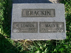
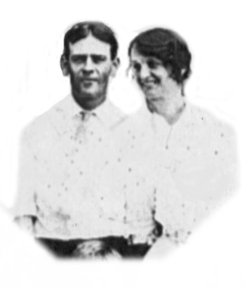
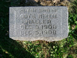
| Description | : | ------------------------- Nellie was the daughter of Cornelius Loman Bracken and Mary Elizabeth Everhart. Nellie (Brackin) and Guy Haller were married December 21, 1907. An infant son was born and died on December 5, 1908. His tombstone is next to his parent's. Contributed by: Osa Bracken, FAG #48621790, 23, Oct 2015 Aunt Nell married Guy Haller on 12/21/1907. After their infant son died, they adopted a daughter, Helen Haller, and raised her adulthood. Contributor: Osa Bracken (48621790) • [email protected] Aunt Nell's brother was William Jacob Bracken - MEMORIAL... Read More |
frequently asked questions (FAQ):
-
Where is Nellie B. “Nell” Brackin Haller's memorial?
Nellie B. “Nell” Brackin Haller's memorial is located at: Mount Olivet Cemetery, Bloomfield, Essex County, USA.
-
When did Nellie B. “Nell” Brackin Haller death?
Nellie B. “Nell” Brackin Haller death on 1 Jun 1970 in Maryville, Nodaway County, Missouri, USA
-
Where are the coordinates of the Nellie B. “Nell” Brackin Haller's memorial?
Latitude: 40.8041992
Longitude: -74.1866989
Family Members:
Parent
Spouse

Siblings
Children
Flowers:


Nearby Cemetories:
1. Mount Olivet Cemetery
Bloomfield, Essex County, USA
Coordinate: 40.8041992, -74.1866989
2. Glendale Cemetery
Bloomfield, Essex County, USA
Coordinate: 40.8067017, -74.1766968
3. Bloomfield Cemetery
Bloomfield, Essex County, USA
Coordinate: 40.8022003, -74.1986008
4. Glen Ridge Congregational Church Garden of Memory
Glen Ridge, Essex County, USA
Coordinate: 40.7978540, -74.2063320
5. Grace Presbyterian Memorial Garden
Montclair, Essex County, USA
Coordinate: 40.8174930, -74.2047140
6. Methodist-Episcopal Churchyard
Bloomfield, Essex County, USA
Coordinate: 40.8260440, -74.1892830
7. Franklin Reformed Churchyard
Nutley, Essex County, USA
Coordinate: 40.8189011, -74.1628036
8. Vincent Cemetery
Nutley, Essex County, USA
Coordinate: 40.8142014, -74.1557999
9. Temple Sharey Tefilo-Israel Cemetery
Montclair, Essex County, USA
Coordinate: 40.7894211, -74.2193298
10. Saint Peters Churchyard
Belleville, Essex County, USA
Coordinate: 40.7849007, -74.1573029
11. Rosedale Cemetery
Montclair, Essex County, USA
Coordinate: 40.7874985, -74.2241974
12. Brookdale Reformed Churchyard
Bloomfield, Essex County, USA
Coordinate: 40.8372002, -74.1875000
13. Belleville Dutch Reformed Churchyard
Belleville, Essex County, USA
Coordinate: 40.7865982, -74.1492996
14. Methodist Burial Ground
Belleville, Essex County, USA
Coordinate: 40.7854850, -74.1498250
15. Christ Church Cemetery and Mausoleum
Belleville, Essex County, USA
Coordinate: 40.7835999, -74.1502991
16. Saint Marys Cemetery
East Orange, Essex County, USA
Coordinate: 40.7682991, -74.1964035
17. Coeyman Family Burial Ground
Newark, Essex County, USA
Coordinate: 40.7765250, -74.1539050
18. Union Congregational Church Memorial Garden
Upper Montclair, Essex County, USA
Coordinate: 40.8390200, -74.2042600
19. Saint Johns Catholic Cemetery
Orange, Essex County, USA
Coordinate: 40.7775345, -74.2309494
20. Mount Pleasant Cemetery
Newark, Essex County, USA
Coordinate: 40.7641983, -74.1641998
21. Crest Haven Memorial Park
Clifton, Passaic County, USA
Coordinate: 40.8372002, -74.1477966
22. Edison National Historic Site
West Orange, Essex County, USA
Coordinate: 40.7862300, -74.2406100
23. King Solomon Memorial Park
Clifton, Passaic County, USA
Coordinate: 40.8417015, -74.1496964
24. First Presbyterian Churchyard
Orange, Essex County, USA
Coordinate: 40.7738000, -74.2342150