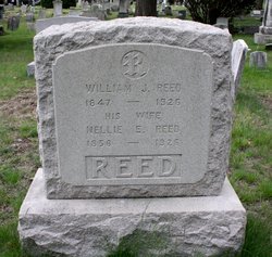
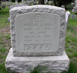
Nellie E. Tague Reed
| Birth | : | 1856 New Hampshire, USA |
| Death | : | 28 Jul 1926 Cranston, Providence County, Rhode Island, USA |
| Burial | : | Grace Church Cemetery, Providence, Providence County, USA |
| Coordinate | : | 41.8112793, -71.4222565 |
| Description | : | death record from familysearch: Rhode Island Deaths and Burials Name Nellie E Reed Gender Female Death Date 28 Jul 1926 Death Place Howard, Cranston, Providence, Rhode Island Age 73 Birth Date 24 Nov 1852 Father's Name John Teague Mother's Name Sarah O'Neil |
frequently asked questions (FAQ):
-
Where is Nellie E. Tague Reed's memorial?
Nellie E. Tague Reed's memorial is located at: Grace Church Cemetery, Providence, Providence County, USA.
-
When did Nellie E. Tague Reed death?
Nellie E. Tague Reed death on 28 Jul 1926 in Cranston, Providence County, Rhode Island, USA
-
Where are the coordinates of the Nellie E. Tague Reed's memorial?
Latitude: 41.8112793
Longitude: -71.4222565
Family Members:
Spouse
Children
Flowers:
Nearby Cemetories:
1. Grace Church Cemetery
Providence, Providence County, USA
Coordinate: 41.8112793, -71.4222565
2. Captain Richard Hoyle Lot (Defunct)
Providence, Providence County, USA
Coordinate: 41.8051150, -71.4198730
3. Old Burial Ground
Providence, Providence County, USA
Coordinate: 41.8048060, -71.4196410
4. West Burial Ground (Defunct)
Providence, Providence County, USA
Coordinate: 41.8161920, -71.4143700
5. Cathedral of Saints Peter and Paul
Providence, Providence County, USA
Coordinate: 41.8188900, -71.4163700
6. First Congregational Society Cemetery (Defunct)
Providence, Providence County, USA
Coordinate: 41.8200960, -71.4141780
7. Locust Grove Cemetery
Providence, Providence County, USA
Coordinate: 41.7997017, -71.4263992
8. Sayles-Payne Lot
Providence, Providence County, USA
Coordinate: 41.7979740, -71.4293630
9. James Harris Lot
Cranston, Providence County, USA
Coordinate: 41.8029870, -71.4395230
10. Resolved Waterman Lot
Johnston, Providence County, USA
Coordinate: 41.8165090, -71.4448440
11. Tillinghast Lot
Providence, Providence County, USA
Coordinate: 41.8205109, -71.4019928
12. Plain Farm Burying Ground (Defunct)
Providence, Providence County, USA
Coordinate: 41.8086780, -71.4479800
13. Governor Nicholas Cooke Lot (Defunct)
Providence, Providence County, USA
Coordinate: 41.8205880, -71.3992760
14. Annmary Brown Memorial
Providence, Providence County, USA
Coordinate: 41.8243000, -71.4025800
15. Captain John Pitcher Lot
Cranston, Providence County, USA
Coordinate: 41.7998000, -71.4444000
16. Roger Williams Burial Ground (Defunct)
Providence, Providence County, USA
Coordinate: 41.8302540, -71.4108870
17. Wamsley Lot
Providence, Providence County, USA
Coordinate: 41.7929720, -71.4078750
18. Colonel Richard Fenner Lot (Defunct)
Cranston, Providence County, USA
Coordinate: 41.7975890, -71.4443760
19. Roger Williams Memorial
Providence, Providence County, USA
Coordinate: 41.8298607, -71.4072189
20. Arnold-Tillinghast Burial Ground (Defunct)
Providence, Providence County, USA
Coordinate: 41.8218700, -71.3965980
21. Saint Johns Cemetery
Providence, Providence County, USA
Coordinate: 41.8313065, -71.4099197
22. Prospect Terrace Park
Providence, Providence County, USA
Coordinate: 41.8308060, -71.4070350
23. Waterman Lot (Defunct)
Providence, Providence County, USA
Coordinate: 41.8219670, -71.4499290
24. Charles Brown Lot (Defunct)
Cranston, Providence County, USA
Coordinate: 41.8104610, -71.4541130


