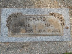
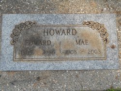
Nellie Mae Howard
| Birth | : | 25 Apr 1908 USA |
| Death | : | 20 Oct 2003 Auburn, Placer County, California, USA |
| Burial | : | Greek Catholic Cemetery, Perth, Clay County, USA |
| Coordinate | : | 39.6036200, -87.1706610 |
| Plot | : | N/C-1-156B-1 |
frequently asked questions (FAQ):
-
Where is Nellie Mae Howard's memorial?
Nellie Mae Howard's memorial is located at: Greek Catholic Cemetery, Perth, Clay County, USA.
-
When did Nellie Mae Howard death?
Nellie Mae Howard death on 20 Oct 2003 in Auburn, Placer County, California, USA
-
Where are the coordinates of the Nellie Mae Howard's memorial?
Latitude: 39.6036200
Longitude: -87.1706610
Family Members:
Flowers:
Nearby Cemetories:
1. Greek Catholic Cemetery
Perth, Clay County, USA
Coordinate: 39.6036200, -87.1706610
2. Mager Cemetery
Carbon, Clay County, USA
Coordinate: 39.6030860, -87.1710960
3. Archer Cemetery
Clay County, USA
Coordinate: 39.6035995, -87.1722031
4. Saint Mary's Cemetery
Carbon, Clay County, USA
Coordinate: 39.6044006, -87.1660995
5. Perth Cemetery
Perth, Clay County, USA
Coordinate: 39.5903015, -87.1613998
6. Webster Cemetery
Brazil, Clay County, USA
Coordinate: 39.5771930, -87.1772110
7. Orchard Cemetery
Carbon, Clay County, USA
Coordinate: 39.6046982, -87.1335983
8. Sampson Cemetery
Clay County, USA
Coordinate: 39.5750008, -87.1643982
9. Denman Cemetery
Parke County, USA
Coordinate: 39.6171989, -87.2118988
10. Crabb Cemetery
Bridgeton, Parke County, USA
Coordinate: 39.6271230, -87.2055890
11. Webster Cemetery
Parke County, USA
Coordinate: 39.6122017, -87.2192001
12. Clear Run Cemetery
Bridgeton, Parke County, USA
Coordinate: 39.6413994, -87.1808014
13. Carter Cemetery
Clay County, USA
Coordinate: 39.5703011, -87.1964035
14. Bell Family Cemetery
Rosedale, Parke County, USA
Coordinate: 39.6195570, -87.2255550
15. Bemis Cemetery
Smockville, Parke County, USA
Coordinate: 39.6167000, -87.1131000
16. Stewart Cemetery
Carbon, Clay County, USA
Coordinate: 39.6034940, -87.1052350
17. Miller Cemetery
Jackson Township, Parke County, USA
Coordinate: 39.6200830, -87.1069580
18. Hartman Family Cemetery
Parke County, USA
Coordinate: 39.6415270, -87.2182780
19. Cress Cemetery
Fontanet, Vigo County, USA
Coordinate: 39.5997009, -87.2414017
20. Poff Cemetery
Clay County, USA
Coordinate: 39.5738983, -87.1106033
21. Brunot Cemetery
Rosedale, Parke County, USA
Coordinate: 39.6349983, -87.2322006
22. Sullivan Cemetery
Fontanet, Vigo County, USA
Coordinate: 39.5808090, -87.2413480
23. Bemis Cemetery
Ehrmandale, Vigo County, USA
Coordinate: 39.5483550, -87.2061220
24. Stunkard Cemetery
Brazil, Clay County, USA
Coordinate: 39.5463982, -87.1346970


