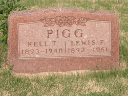
Nellie Temple Elliott Pigg
| Birth | : | 16 Jul 1893 Orrick, Ray County, Missouri, USA |
| Death | : | 26 Apr 1940 Kansas City, Jackson County, Missouri, USA |
| Burial | : | Saint Patrick Cemetery, Jaffrey, Cheshire County, USA |
| Coordinate | : | 42.8158600, -72.0100000 |
| Plot | : | Section 6 |
| Description | : | Nellie Temple Elliott was a daughter of Theopolis Garner Elliott and Caroline E. "Carrie" Lile Elliott. She had, at least, two siblings. Nellie Temple Elliott married Lewis Freeman Pigg. Nellie Temple Elliott was 46 years and 8 months and 10 days old at the time of her death. ----- NOTES: Other possible names for her father: E. Grant Elliott Garner T. Elliott Missouri Death Certificate shows: Father: Garner Elliott Mother: Cary T. Will If anyone has more/better information, please contact me. |
frequently asked questions (FAQ):
-
Where is Nellie Temple Elliott Pigg's memorial?
Nellie Temple Elliott Pigg's memorial is located at: Saint Patrick Cemetery, Jaffrey, Cheshire County, USA.
-
When did Nellie Temple Elliott Pigg death?
Nellie Temple Elliott Pigg death on 26 Apr 1940 in Kansas City, Jackson County, Missouri, USA
-
Where are the coordinates of the Nellie Temple Elliott Pigg's memorial?
Latitude: 42.8158600
Longitude: -72.0100000
Family Members:
Parent
Spouse
Siblings
Children
Nearby Cemetories:
1. Saint Patrick Cemetery
Jaffrey, Cheshire County, USA
Coordinate: 42.8158600, -72.0100000
2. Village Cemetery
Jaffrey Center, Cheshire County, USA
Coordinate: 42.8128200, -72.0175000
3. Smallpox Cemetery
Jaffrey, Cheshire County, USA
Coordinate: 42.8231700, -72.0030500
4. Conant Cemetery
Jaffrey, Cheshire County, USA
Coordinate: 42.8083000, -72.0164600
5. Cutters Cemetery
Jaffrey Center, Cheshire County, USA
Coordinate: 42.8266710, -72.0483190
6. Old Burying Ground
Jaffrey Center, Cheshire County, USA
Coordinate: 42.8287500, -72.0573200
7. Cathedral of the Pines Cemetery
Rindge, Cheshire County, USA
Coordinate: 42.7749900, -71.9901800
8. North Cemetery
Sharon, Hillsborough County, USA
Coordinate: 42.8316000, -71.9347900
9. Jarmany Hill Cemetery
Sharon, Hillsborough County, USA
Coordinate: 42.8038100, -71.9289300
10. Meeting House Cemetery
Rindge, Cheshire County, USA
Coordinate: 42.7501200, -72.0096700
11. Hillside Cemetery
Rindge, Cheshire County, USA
Coordinate: 42.7463000, -72.0063900
12. Wood Family Cemetery
Rindge, Cheshire County, USA
Coordinate: 42.7457040, -71.9859410
13. Phillips-Heil Cemetery
Jaffrey, Cheshire County, USA
Coordinate: 42.8189049, -72.1105576
14. Saint Peter Church Cemetery
Peterborough, Hillsborough County, USA
Coordinate: 42.8791980, -71.9510690
15. All Saints Church
Peterborough, Hillsborough County, USA
Coordinate: 42.8805690, -71.9460160
16. Village Cemetery
Peterborough, Hillsborough County, USA
Coordinate: 42.8816986, -71.9464035
17. MacDowell Cemetery
Peterborough, Hillsborough County, USA
Coordinate: 42.8891983, -71.9610977
18. Old Street Cemetery
Peterborough, Hillsborough County, USA
Coordinate: 42.8802490, -71.9376068
19. Pine Hill Cemetery
Peterborough, Hillsborough County, USA
Coordinate: 42.8877983, -71.9441986
20. Saint Peters Cemetery
Peterborough, Hillsborough County, USA
Coordinate: 42.8913994, -71.9518967
21. Rand Cemetery
Rindge, Cheshire County, USA
Coordinate: 42.7350006, -72.0582962
22. Wilder Cemetery
Rindge, Cheshire County, USA
Coordinate: 42.7395400, -71.9404900
23. Robbins Cemetery
Rindge, Cheshire County, USA
Coordinate: 42.7266670, -72.0638890
24. Robbins Burial Ground
Rindge, Cheshire County, USA
Coordinate: 42.7268982, -72.0658035


