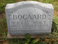
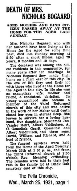
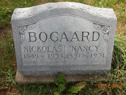
Nennetje “Nancy” Middendorf Bogaard
| Birth | : | 10 Jun 1851 Netherlands |
| Death | : | 20 Mar 1931 Pella, Marion County, Iowa, USA |
| Burial | : | Carinya Gardens, Mount Gambier, Mount Gambier City, Australia |
| Coordinate | : | -37.8370330, 140.7494970 |
| Description | : | Daughter of Willem Middendorf and Jennie van der Wal. At least one sibling: Betsey. Married: Nickolas Bogaard, son of Arie and Wyntje (van Woudenberg) Bogaard/Boogaard, on February 27, 1871 in Marion County, Iowa. Census records show the couple lived in Richland in Mahaska County most of their married life. By 1920, they had moved to Pella. Children: Wyntje (Winnie), Jennie, Arie [died young], Bessie, Josie, William Nicholas, Dirk (Dick), Nennetje (Nettie), Cornelia (Kate), Arena [died young], David. |
frequently asked questions (FAQ):
-
Where is Nennetje “Nancy” Middendorf Bogaard's memorial?
Nennetje “Nancy” Middendorf Bogaard's memorial is located at: Carinya Gardens, Mount Gambier, Mount Gambier City, Australia.
-
When did Nennetje “Nancy” Middendorf Bogaard death?
Nennetje “Nancy” Middendorf Bogaard death on 20 Mar 1931 in Pella, Marion County, Iowa, USA
-
Where are the coordinates of the Nennetje “Nancy” Middendorf Bogaard's memorial?
Latitude: -37.8370330
Longitude: 140.7494970
Family Members:
Spouse
Children
Flowers:
Nearby Cemetories:
1. Pioneer Park
Mount Gambier, Mount Gambier City, Australia
Coordinate: -37.8348290, 140.7840010
2. Mieschel Park
Mount Gambier, Mount Gambier City, Australia
Coordinate: -37.8374980, 140.7855890
3. Lake Terrace Cemetery
Mount Gambier, Mount Gambier City, Australia
Coordinate: -37.8425950, 140.7854720
4. Port MacDonnell Lighthouse Cemetery
Port MacDonnell, District Council of Grant, Australia
Coordinate: -38.0558330, 140.6630560
5. Kalangadoo Cemetery
Kalangadoo, Wattle Range Council, Australia
Coordinate: -37.5694190, 140.7045780
6. Nelson Cemetery
Nelson, Glenelg Shire, Australia
Coordinate: -38.0359977, 141.0123516
7. Strathdownie Cemetery
Strathdownie, Glenelg Shire, Australia
Coordinate: -37.7174000, 141.1676280
8. Millicent Cemetery
Millicent, Wattle Range Council, Australia
Coordinate: -37.6184335, 140.3770980
9. Dartmoor Cemetery
Dartmoor, Glenelg Shire, Australia
Coordinate: -37.9148220, 141.2491380
10. Heathfield Cemetery
Lake Mundi, Glenelg Shire, Australia
Coordinate: -37.5713233, 141.1436213
11. Penola Cemetery
Penola, Wattle Range Council, Australia
Coordinate: -37.4009210, 140.8362800
12. Drik Drik Cemetery
Drik Drik, Glenelg Shire, Australia
Coordinate: -37.9858333, 141.2952778
13. Penola Old Cemetery
Penola, Wattle Range Council, Australia
Coordinate: -37.3670740, 140.8412400
14. Casterton Old Cemetery
Casterton, Glenelg Shire, Australia
Coordinate: -37.5948850, 141.3700380
15. Casterton Cemetery
Casterton, Glenelg Shire, Australia
Coordinate: -37.5992440, 141.4088270
16. Digby Cemetery
Digby, Glenelg Shire, Australia
Coordinate: -37.8196840, 141.5040810
17. Sandford Cemetery
Sandford, Glenelg Shire, Australia
Coordinate: -37.6290998, 141.4562576
18. Dergholm Cemetery
Dergholm, West Wimmera Shire, Australia
Coordinate: -37.3717520, 141.2253000
19. Rifle Ranges Pastoral Run
Digby, Glenelg Shire, Australia
Coordinate: -37.7813184, 141.5104222
20. Merino Cemetery
Merino, Glenelg Shire, Australia
Coordinate: -37.6908180, 141.5434050
21. Beachport Cemetery
Beachport, Wattle Range Council, Australia
Coordinate: -37.4725340, 140.0475120
22. Hotspur Cemetery
Hotspur, Glenelg Shire, Australia
Coordinate: -37.9297580, 141.5866650
23. Corkhill Station Cemetery
Cape Bridgewater, Glenelg Shire, Australia
Coordinate: -38.3451060, 141.4092120
24. Cape Bridgewater Cemetery
Cape Bridgewater Lower, Glenelg Shire, Australia
Coordinate: -38.3396480, 141.4298350


