

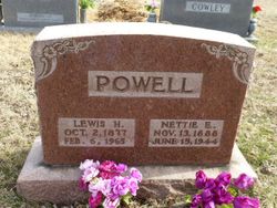

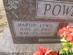
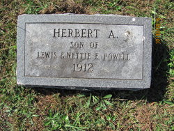
Nettie Emma Meyer Powell
| Birth | : | 13 Nov 1887 Farmington, St. Francois County, Missouri, USA |
| Death | : | 15 Jun 1944 Farmington, St. Francois County, Missouri, USA |
| Burial | : | Oak Grove Cemetery, Springfield, Hampden County, USA |
| Coordinate | : | 42.1264000, -72.5625000 |
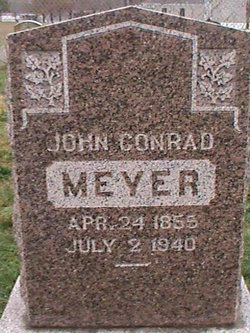
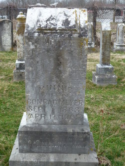
| Description | : | Wife of Lewis H. Powell Married May 28 1908 Missouri Daughter of John Conrad Meyer & Minnie Hildebrecht |
frequently asked questions (FAQ):
-
Where is Nettie Emma Meyer Powell's memorial?
Nettie Emma Meyer Powell's memorial is located at: Oak Grove Cemetery, Springfield, Hampden County, USA.
-
When did Nettie Emma Meyer Powell death?
Nettie Emma Meyer Powell death on 15 Jun 1944 in Farmington, St. Francois County, Missouri, USA
-
Where are the coordinates of the Nettie Emma Meyer Powell's memorial?
Latitude: 42.1264000
Longitude: -72.5625000
Family Members:
Parent
Spouse

Siblings
Children

Flowers:


Nearby Cemetories:
1. Oak Grove Cemetery
Springfield, Hampden County, USA
Coordinate: 42.1264000, -72.5625000
2. Bay Path Cemetery
Springfield, Hampden County, USA
Coordinate: 42.1231003, -72.5519028
3. Saint Michael's Cemetery
Springfield, Hampden County, USA
Coordinate: 42.1240997, -72.5392914
4. Saint Benedict's Cemetery
Springfield, Hampden County, USA
Coordinate: 42.1194000, -72.5841980
5. Polish National Cemetery
Springfield, Hampden County, USA
Coordinate: 42.1441870, -72.5417380
6. Fairview Cemetery
Chicopee, Hampden County, USA
Coordinate: 42.1389008, -72.5894012
7. City of Homes Cemetery
Springfield, Hampden County, USA
Coordinate: 42.1142980, -72.5316060
8. Sons of Israel Cemetery
Springfield, Hampden County, USA
Coordinate: 42.1143000, -72.5316000
9. Holy Mother of the Rosary Cemetery
Chicopee, Hampden County, USA
Coordinate: 42.1411018, -72.5916977
10. Kesser Israel Cemetery
Springfield, Hampden County, USA
Coordinate: 42.1145610, -72.5304670
11. Springfield Cemetery
Springfield, Hampden County, USA
Coordinate: 42.1015180, -72.5764990
12. Saint Augustine Mortuary Chapel
Springfield, Hampden County, USA
Coordinate: 42.1043400, -72.5845200
13. Saint Michaels Churchyard
Springfield, Hampden County, USA
Coordinate: 42.1040970, -72.5841540
14. Sacred Heart Churchyard
Springfield, Hampden County, USA
Coordinate: 42.1122640, -72.5957250
15. Saint Matthew Cemetery
Springfield, Hampden County, USA
Coordinate: 42.1310680, -72.6003280
16. Cherry Lane Cemetery
Springfield, Hampden County, USA
Coordinate: 42.0971985, -72.5689011
17. Sinai Memorial Park
Springfield, Hampden County, USA
Coordinate: 42.1427994, -72.5291977
18. Old Burying Ground (Defunct)
Springfield, Hampden County, USA
Coordinate: 42.1014190, -72.5879840
19. Korean War Memorial
Chicopee, Hampden County, USA
Coordinate: 42.1478110, -72.5934600
20. East Street Cemetery
Chicopee, Hampden County, USA
Coordinate: 42.1556015, -72.5792007
21. Calvary Cemetery
Chicopee, Hampden County, USA
Coordinate: 42.1347008, -72.6042023
22. Holy Name of Jesus Churchyard
Chicopee, Hampden County, USA
Coordinate: 42.1446810, -72.6052570
23. Maple Grove Cemetery
Chicopee, Hampden County, USA
Coordinate: 42.1478004, -72.6027985
24. Saint Patricks Cemetery
Chicopee, Hampden County, USA
Coordinate: 42.1652985, -72.5708008