
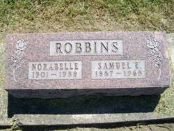
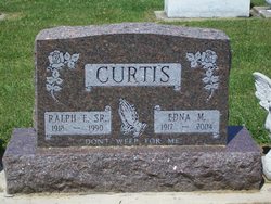
Norabelle Curtis Robbins
| Birth | : | 1 Apr 1901 Fulton County, Indiana, USA |
| Death | : | 20 Sep 1959 |
| Burial | : | Colrain West Branch Cemetery, Colrain, Franklin County, USA |
| Coordinate | : | 42.6671982, -72.7221985 |
| Plot | : | Section 13, Row 6 |
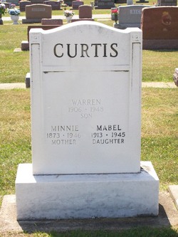
| Description | : | Published in The Rochester News-Sentinel Monday, September 21, 1959 Norabelle Robbins Mrs. Samuel E. (Norabelle) CURTIS ROBBINS, 58, 331 Indiana avenue, died of a heart attack while riding in a car on Ind. 14 1 1/2 miles east of Winamac at 2:30 p.m. Sunday. She had been ill two years. Born in Fulton county April 1, 1901, she had lived in Rochester and vicinity her entire life. She was the daughter of Mahlon and Minnie Belle CURTIS. On July 7, 1941, she was married in Rochester to Samuel E. ROBBINS, who survives. Also surviving are a daughter, Wanda Louise [ROBBINS], at home; a son, DeVon SHUMAN,... Read More |
frequently asked questions (FAQ):
-
Where is Norabelle Curtis Robbins's memorial?
Norabelle Curtis Robbins's memorial is located at: Colrain West Branch Cemetery, Colrain, Franklin County, USA.
-
When did Norabelle Curtis Robbins death?
Norabelle Curtis Robbins death on 20 Sep 1959 in
-
Where are the coordinates of the Norabelle Curtis Robbins's memorial?
Latitude: 42.6671982
Longitude: -72.7221985
Family Members:
Parent

Spouse

Siblings


Children
Flowers:


Nearby Cemetories:
1. Colrain West Branch Cemetery
Colrain, Franklin County, USA
Coordinate: 42.6671982, -72.7221985
2. Chandler Hill Cemetery
Colrain, Franklin County, USA
Coordinate: 42.6683006, -72.6832962
3. North River Cemetery
Colrain, Franklin County, USA
Coordinate: 42.6856003, -72.6917038
4. Brick School Cemetery
Colrain, Franklin County, USA
Coordinate: 42.6641998, -72.6660995
5. Arms Cemetery
Shelburne Falls, Franklin County, USA
Coordinate: 42.6166992, -72.7332993
6. Christian Hill Cemetery
Colrain, Franklin County, USA
Coordinate: 42.7158012, -72.7643967
7. West Leyden Cemetery
Leyden, Franklin County, USA
Coordinate: 42.7061005, -72.6572037
8. East Shelburne Cemetery
Shelburne, Franklin County, USA
Coordinate: 42.6105995, -72.6694031
9. South Leyden Cemetery
Leyden, Franklin County, USA
Coordinate: 42.6831400, -72.6311200
10. East Charlemont Cemetery
Charlemont, Franklin County, USA
Coordinate: 42.6197853, -72.7932739
11. Center Cemetery
Heath, Franklin County, USA
Coordinate: 42.6819000, -72.8167038
12. Henry Farm Cemetery
West Halifax, Windham County, USA
Coordinate: 42.7379712, -72.7132938
13. Brown Cemetery
West Dummerston, Windham County, USA
Coordinate: 42.7392340, -72.7135850
14. Hill Cemetery
Shelburne, Franklin County, USA
Coordinate: 42.5984344, -72.6878815
15. East Buckland Cemetery
Buckland, Franklin County, USA
Coordinate: 42.5962500, -72.7610600
16. Bell Cemetery
Halifax, Windham County, USA
Coordinate: 42.7423800, -72.6972900
17. Old East Buckland Cemetery
Buckland, Franklin County, USA
Coordinate: 42.5969400, -72.7677900
18. Stark Cemetery
Guilford, Windham County, USA
Coordinate: 42.7402992, -72.6746979
19. Clark Family Cemetery
Halifax, Windham County, USA
Coordinate: 42.7479180, -72.7103090
20. South Cemetery
Heath, Franklin County, USA
Coordinate: 42.6542015, -72.8321991
21. North Meadows Cemetery
Greenfield, Franklin County, USA
Coordinate: 42.6171989, -72.6333008
22. Country Farms Cemetery
Greenfield, Franklin County, USA
Coordinate: 42.6393900, -72.6165400
23. Pennel Hill Cemetery
Halifax, Windham County, USA
Coordinate: 42.7364006, -72.7857971
24. Shelburne Center Cemetery
Shelburne, Franklin County, USA
Coordinate: 42.5830000, -72.6969600