
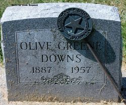
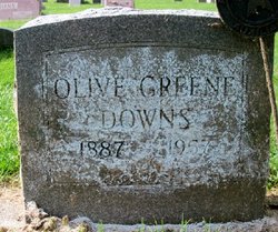
Olive Lenore Brode Greene
| Birth | : | 18 Aug 1887 West Bend, Palo Alto County, Iowa, USA |
| Death | : | 19 May 1957 Estherville, Emmet County, Iowa, USA |
| Burial | : | Riverside Cemetery, Spencer, Clay County, USA |
| Coordinate | : | 43.1441994, -95.1671982 |
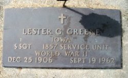
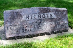
| Description | : | Daughter of John Andrew Brode & Elsie Ann Mitcheltree. Married Harry Garfield Greene on 22 Feb 1906. Had four sons, Lester Garfield, Leo, Leonard and Harry, plus two daughters, Leonara (Mrs. Edward) Craig and Loretta Mae (Mrs. Albert LeRoy) Nichols. OBITUARY, The Graettinger Times, 20 June 1957, page 1: Mrs. Leo (Olive) Downs, 69, a longtime resident of this community, died early Wednesday morning following an illness of several months. She had been hospitalized much of the time in recent months and was at the Good Samaritan Home in Estherville at the time of her death.... Read More |
frequently asked questions (FAQ):
-
Where is Olive Lenore Brode Greene's memorial?
Olive Lenore Brode Greene's memorial is located at: Riverside Cemetery, Spencer, Clay County, USA.
-
When did Olive Lenore Brode Greene death?
Olive Lenore Brode Greene death on 19 May 1957 in Estherville, Emmet County, Iowa, USA
-
Where are the coordinates of the Olive Lenore Brode Greene's memorial?
Latitude: 43.1441994
Longitude: -95.1671982
Family Members:
Parent
Spouse
Siblings
Children

Flowers:


Nearby Cemetories:
1. Riverside Cemetery
Spencer, Clay County, USA
Coordinate: 43.1441994, -95.1671982
2. Dewey Readmore Books Memorial
Spencer, Clay County, USA
Coordinate: 43.1403999, -95.1443024
3. North Lawn Cemetery
Spencer, Clay County, USA
Coordinate: 43.1600000, -95.1470000
4. Evergreen Cemetery
Clay County, USA
Coordinate: 43.2052994, -95.2086029
5. Fairview Cemetery
Clay County, USA
Coordinate: 43.1899986, -95.0800018
6. Swedish Lutheran Cemetery
Royal, Clay County, USA
Coordinate: 43.0683000, -95.2350000
7. Dickens Cemetery
Dickens, Clay County, USA
Coordinate: 43.1280000, -95.0155000
8. Rosehill Cemetery
Clay County, USA
Coordinate: 43.0368996, -95.0919037
9. Lone Tree Cemetery
Everly, Clay County, USA
Coordinate: 43.1411018, -95.3347015
10. Little Sioux Lutheran Cemetery
Milford, Dickinson County, USA
Coordinate: 43.2702065, -95.2109528
11. First Reformed Cemetery
Clay County, USA
Coordinate: 43.2399500, -95.2889000
12. Lincoln Cemetery
Rossie, Clay County, USA
Coordinate: 43.0111008, -95.2313995
13. Willow Creek Cemetery
Royal, Clay County, USA
Coordinate: 43.0214005, -95.2885971
14. Liberty Cemetery
Greenville, Clay County, USA
Coordinate: 42.9897003, -95.1417007
15. Clay Center Cemetery
Royal, Clay County, USA
Coordinate: 43.0410995, -95.3272018
16. Milford Cemetery
Milford, Dickinson County, USA
Coordinate: 43.3092003, -95.1481018
17. TriMello Cemetery
Royal, Clay County, USA
Coordinate: 43.0682983, -95.3728027
18. Logan Township Cemetery
Clay County, USA
Coordinate: 43.0489006, -94.9747009
19. Zion Methodist Cemetery
Clay County, USA
Coordinate: 42.9808006, -95.2497025
20. Calvary Cemetery
Milford, Dickinson County, USA
Coordinate: 43.3213997, -95.1688995
21. Fanny Fern Cemetery
Clay County, USA
Coordinate: 42.9530983, -95.1607971
22. Crown Hill Cemetery
Ruthven, Palo Alto County, USA
Coordinate: 43.1328011, -94.8878021
23. Calvary Cemetery
Ruthven, Palo Alto County, USA
Coordinate: 43.1314011, -94.8869019
24. Westport Cemetery
Dickinson County, USA
Coordinate: 43.3130989, -95.3289032