

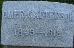
Omer Martin Catterson
| Birth | : | 17 Sep 1849 Marion County, Indiana, USA |
| Death | : | 10 May 1918 Maryville, Nodaway County, Missouri, USA |
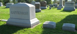
| Burial | : | Bluff Cemetery, Springdale, Washington County, USA |
| Coordinate | : | 36.1931000, -94.1327972 |
| Plot | : | Near the entrance |
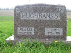
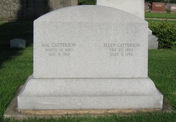
| Description | : | Born Wayne Township, Marion County, Indiana. Father was Daniel B. Catterson, mother was Sarah Jane Martin. Lost father at age 2, raised by stepfather Abraham Hughbanks. Married to Louisa Lavena Evans, 3 April,1873 in Lebanon,Boone County, Indiana. Moved to Missouri, farmed in White Cloud Township, Nodaway County 1873-1881. Purchased Newt Wray farm 2 miles north of Maryville, in 1881, farmed until death. Was the first to breed purebred Aberdeen Angus cattle in Nodaway County, became a well known breeder, and won many awards at stock shows across the midwest, including Chicago, Omaha, and Kansas City. Died from a sinus infection... Read More |
frequently asked questions (FAQ):
-
Where is Omer Martin Catterson's memorial?
Omer Martin Catterson's memorial is located at: Bluff Cemetery, Springdale, Washington County, USA.
-
When did Omer Martin Catterson death?
Omer Martin Catterson death on 10 May 1918 in Maryville, Nodaway County, Missouri, USA
-
Where are the coordinates of the Omer Martin Catterson's memorial?
Latitude: 36.1931000
Longitude: -94.1327972
Family Members:
Parent
Spouse
Siblings
Children
Flowers:


Nearby Cemetories:
1. Bluff Cemetery
Springdale, Washington County, USA
Coordinate: 36.1931000, -94.1327972
2. First United Methodist Church Columbarium
Springdale, Washington County, USA
Coordinate: 36.1866850, -94.1329800
3. Forest Park Cemetery
Springdale, Washington County, USA
Coordinate: 36.2024994, -94.1363983
4. Holcomb Cemetery
Springdale, Washington County, USA
Coordinate: 36.1828003, -94.1436005
5. Fitzgerald Cemetery
Springdale, Washington County, USA
Coordinate: 36.2025640, -94.1199040
6. Salem Lutheran Church Cemetery
Springdale, Washington County, USA
Coordinate: 36.1886060, -94.1493120
7. First Presbyterian Columbarium
Springdale, Washington County, USA
Coordinate: 36.1843530, -94.1625690
8. Silent Grove Cemetery
Benton County, USA
Coordinate: 36.2216670, -94.1598540
9. Wilson Cemetery
Lowell, Benton County, USA
Coordinate: 36.2108002, -94.0847015
10. Ingram Cemetery
Lowell, Benton County, USA
Coordinate: 36.2316055, -94.1059647
11. Friendship Cemetery
Springdale, Washington County, USA
Coordinate: 36.1681280, -94.0854990
12. Shady Grove Cemetery
Springdale, Washington County, USA
Coordinate: 36.1460991, -94.1483002
13. Saint Thomas Episcopal Church Columbarium
Springdale, Washington County, USA
Coordinate: 36.1604100, -94.1843600
14. Sharp Cemetery
Benton County, USA
Coordinate: 36.2241880, -94.1868240
15. Phillips Cemetery
Lowell, Benton County, USA
Coordinate: 36.2380981, -94.0960999
16. Spring Creek Cemetery
Cave Springs, Benton County, USA
Coordinate: 36.2261009, -94.1917038
17. Goad Springs Cemetery
Lowell, Benton County, USA
Coordinate: 36.2496986, -94.1530991
18. Zion Cemetery
Springdale, Washington County, USA
Coordinate: 36.1327100, -94.0962230
19. Stuckey Cemetery
Johnson, Washington County, USA
Coordinate: 36.1383018, -94.1866989
20. Oakland Cemetery
Fayetteville, Washington County, USA
Coordinate: 36.1232990, -94.1026670
21. Stearns Cemetery
Fayetteville, Washington County, USA
Coordinate: 36.1150017, -94.1397018
22. Elm Springs Cemetery
Elm Springs, Washington County, USA
Coordinate: 36.2060020, -94.2287270
23. Sonora Cemetery
Sonora, Washington County, USA
Coordinate: 36.1652390, -94.0409630
24. Saint Joseph Cemetery
Tontitown, Washington County, USA
Coordinate: 36.1685982, -94.2350006