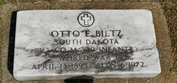
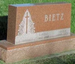
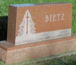
Otto Emil Bietz
| Birth | : | 13 Apr 1895 Tripp, Hutchinson County, South Dakota, USA |
| Death | : | 6 Jan 1972 Tripp, Hutchinson County, South Dakota, USA |
| Burial | : | Mount Horeb Cemetery, Jefferson County, USA |
| Coordinate | : | 36.0917015, -83.4300003 |
| Plot | : | Section 14 Lot 7 |
| Description | : | Daily Republic- 1/6/72 Funeral services for Otto E. Bietz, 76, will be at 1:30 pm Saturday at the American Legion Church with the Rev. Erwin E. Groth, officiating. Friends may call Friday afternoon and evening at the Petrik Funeral Home in Tripp. Burial will be in the Gracehill Cemetery with Military Rites by the American Legion. Mr. Bietz was born April 13, 1895 at Tripp to Mr. and Mrs. Fred Bietz and died Jan. 6 at the Parkston hospital. He had served in France in the Army during World War I. On Dec 29, 1927 he married Martha Freitag at Kaylor and they... Read More |
frequently asked questions (FAQ):
-
Where is Otto Emil Bietz's memorial?
Otto Emil Bietz's memorial is located at: Mount Horeb Cemetery, Jefferson County, USA.
-
When did Otto Emil Bietz death?
Otto Emil Bietz death on 6 Jan 1972 in Tripp, Hutchinson County, South Dakota, USA
-
Where are the coordinates of the Otto Emil Bietz's memorial?
Latitude: 36.0917015
Longitude: -83.4300003
Family Members:
Spouse
Flowers:
Nearby Cemetories:
1. Mount Horeb Cemetery
Jefferson County, USA
Coordinate: 36.0917015, -83.4300003
2. Lebanon Cemetery
Jefferson County, USA
Coordinate: 36.0932999, -83.4424973
3. Lebanon Cumberland Presbyterian Church Cemetery
Jefferson City, Jefferson County, USA
Coordinate: 36.0933600, -83.4426600
4. Mountain View Cemetery
Mount Horeb, Jefferson County, USA
Coordinate: 36.0816994, -83.4186020
5. Buffalo Grove Cemetery
Jefferson City, Jefferson County, USA
Coordinate: 36.1148500, -83.4530800
6. Hebron Cemetery
Jefferson County, USA
Coordinate: 36.0572014, -83.4471970
7. Mansfield Cemetery
Jefferson County, USA
Coordinate: 36.0881004, -83.3796997
8. Balch Cemetery
Jefferson County, USA
Coordinate: 36.0600014, -83.3977966
9. Holy Trinity Catholic Church Cemetery
Jefferson City, Jefferson County, USA
Coordinate: 36.0727630, -83.4779500
10. Mount Pleasant United Methodist Church Cemetery
Talbott, Jefferson County, USA
Coordinate: 36.1323280, -83.4082031
11. Community Chapel Freewill Baptist Church Cemetery
Jefferson County, USA
Coordinate: 36.1273360, -83.3892030
12. Jefferson Memorial Gardens Cemetery
Jefferson City, Jefferson County, USA
Coordinate: 36.1366997, -83.4561005
13. Grant's Chapel Cemetery
Grants Chapel, Jefferson County, USA
Coordinate: 36.0400860, -83.4414730
14. Oakland Cemetery
Jefferson County, USA
Coordinate: 36.0517006, -83.4721985
15. Flat Gap Cemetery
Flat Gap, Jefferson County, USA
Coordinate: 36.0746900, -83.4958600
16. Branner Cemetery
Jefferson City, Jefferson County, USA
Coordinate: 36.1307983, -83.4841995
17. Mossy Creek Baptist Cemetery
Jefferson City, Jefferson County, USA
Coordinate: 36.1225560, -83.4934550
18. Jefferson County Farm Cemetery
Jefferson County, USA
Coordinate: 36.0285988, -83.4216995
19. Ebenezer Methodist Cemetery
Jefferson City, Jefferson County, USA
Coordinate: 36.0994400, -83.3491600
20. Old Miller Cemetery
Talbott, Jefferson County, USA
Coordinate: 36.1189003, -83.3553009
21. Pleasant Ridge Cemetery
Talbott, Jefferson County, USA
Coordinate: 36.1406021, -83.3744812
22. Dandridge Cemetery
Dandridge, Jefferson County, USA
Coordinate: 36.0249000, -83.4267900
23. Westview Cemetery
Jefferson City, Jefferson County, USA
Coordinate: 36.1225014, -83.5044022
24. Grace Baptist Church Cemetery
Dandridge, Jefferson County, USA
Coordinate: 36.0304600, -83.3891100


