
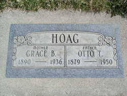
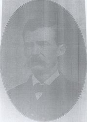
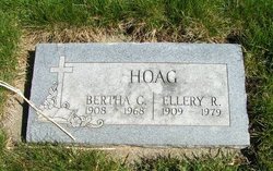
Otto Thurlow Hoag
| Birth | : | 6 Aug 1879 Union, Franklin County, Missouri, USA |
| Death | : | 14 Jul 1950 Kettle Falls, Stevens County, Washington, USA |
| Burial | : | South Lawn Cemetery, Piermont, Grafton County, USA |
| Coordinate | : | 43.9667600, -72.0812500 |
| Plot | : | North Fraternal Row25 BLK28 LS3 |
| Inscription | : | Grace B Hoag |
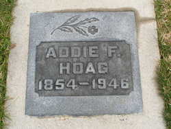
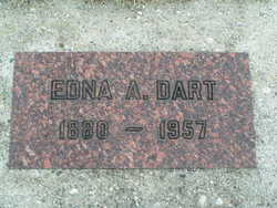
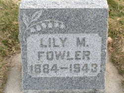
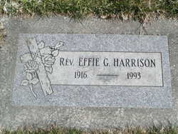
| Description | : | Chelan, July 15 – Otto T. Hoag, 70, died last night at Kettle Falls after a brief illness. Born in West Union, Mo., on August 6, 1879, he came to Chelan in 1891, where he resided until three years ago. Since then, he has made his home with his son near Kettle Falls. Mrs. Hoag preceded him in death in 1936. Surviving are one sister, Mrs. Edna Dart of Chelan; two daughters, Mrs. C. H. Harrison of Chelan and Miss Doris Hoag of Tacoma; one son, Ellery Hoag of Evans; and one grandchild. Funeral services will be held Monday. Smith... Read More |
frequently asked questions (FAQ):
-
Where is Otto Thurlow Hoag's memorial?
Otto Thurlow Hoag's memorial is located at: South Lawn Cemetery, Piermont, Grafton County, USA.
-
When did Otto Thurlow Hoag death?
Otto Thurlow Hoag death on 14 Jul 1950 in Kettle Falls, Stevens County, Washington, USA
-
Where are the coordinates of the Otto Thurlow Hoag's memorial?
Latitude: 43.9667600
Longitude: -72.0812500
Family Members:
Parent
Spouse

Siblings
Children
Flowers:


Nearby Cemetories:
1. South Lawn Cemetery
Piermont, Grafton County, USA
Coordinate: 43.9667600, -72.0812500
2. Cedar Grove Cemetery
Piermont, Grafton County, USA
Coordinate: 43.9720300, -72.0813400
3. Clay Hollow Cemetery
Piermont, Grafton County, USA
Coordinate: 43.9597220, -72.0333330
4. River Road Cemetery
Piermont, Grafton County, USA
Coordinate: 44.0019500, -72.1013600
5. Upper Plain Cemetery
Bradford, Orange County, USA
Coordinate: 44.0084900, -72.1097200
6. Sawyer Cemetery
Bradford, Orange County, USA
Coordinate: 44.0085800, -72.1101000
7. Brushwood Cemetery
Fairlee, Orange County, USA
Coordinate: 43.9628600, -72.1623700
8. Fairlee Village Cemetery
Fairlee, Orange County, USA
Coordinate: 43.9154900, -72.1321900
9. Rodimon-Cross Cemetery
Piermont, Grafton County, USA
Coordinate: 43.9901100, -71.9924500
10. West Cemetery
Orford, Grafton County, USA
Coordinate: 43.9081970, -72.1312760
11. Dame Hill Cemetery
Orford, Grafton County, USA
Coordinate: 43.8945370, -72.0833370
12. Kidderhood Cemetery
West Fairlee, Orange County, USA
Coordinate: 43.9719034, -72.1869267
13. Ladd Street Cemetery
Haverhill, Grafton County, USA
Coordinate: 44.0439600, -72.0532800
14. East Orford Cemetery
Orford, Grafton County, USA
Coordinate: 43.9096900, -72.0032600
15. East Piermont Cemetery
Piermont, Grafton County, USA
Coordinate: 43.9438890, -71.9689890
16. Goshen Cemetery (Defunct)
Bradford, Orange County, USA
Coordinate: 44.0402170, -72.1469029
17. West Bradford Cemetery
Bradford, Orange County, USA
Coordinate: 44.0031700, -72.1957600
18. Lund Cemetery
Warren, Grafton County, USA
Coordinate: 43.9882800, -71.9589200
19. Wild Hill Cemetery
West Fairlee, Orange County, USA
Coordinate: 43.9587300, -72.2070600
20. East Haverhill Cemetery
East Haverhill, Grafton County, USA
Coordinate: 44.0289688, -71.9889297
21. Bloodbrook Cemetery
West Fairlee, Orange County, USA
Coordinate: 43.9319941, -72.2026967
22. Rogers Hill Cemetery
West Newbury, Orange County, USA
Coordinate: 44.0550003, -72.1322021
23. West Newbury Cemetery
West Newbury, Orange County, USA
Coordinate: 44.0591800, -72.1246900
24. Scruton Hill Cemetery
West Fairlee, Orange County, USA
Coordinate: 43.9667705, -72.2220608