
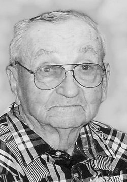
Ova Manford Sharr
| Birth | : | 11 Aug 1931 Maryville, Nodaway County, Missouri, USA |
| Death | : | 12 Feb 2017 Stanberry, Gentry County, Missouri, USA |
| Burial | : | West Union Cemetery, Orrsburg, Nodaway County, USA |
| Coordinate | : | 40.4307400, -94.7186000 |
| Description | : | Ova Manford Sharr, 85, Maryville, MO died Sunday, February 12, 2017, at Pineview Manor, Inc. in Stanberry, Missouri. He was born August 11, 1931 in Maryville, the son John Austin and Elsie Groves Sharr. Ova was a 1950 graduate of Burlington Junction High School, and was the owner and operator of Sharr Garage in Maryville. Ova served his country during the Korean War, with the United States Navy. He belonged to the Tri-C American Legion Post #464 in Conception Jct., MO. Preceding him in death were his parents, son John Sharr, brother Wilmer Sharr and sister Burl Tise. Ova is survived by his daughter... Read More |
frequently asked questions (FAQ):
-
Where is Ova Manford Sharr's memorial?
Ova Manford Sharr's memorial is located at: West Union Cemetery, Orrsburg, Nodaway County, USA.
-
When did Ova Manford Sharr death?
Ova Manford Sharr death on 12 Feb 2017 in Stanberry, Gentry County, Missouri, USA
-
Where are the coordinates of the Ova Manford Sharr's memorial?
Latitude: 40.4307400
Longitude: -94.7186000
Family Members:
Parent

Siblings
Children
Flowers:


Nearby Cemetories:
1. West Union Cemetery
Orrsburg, Nodaway County, USA
Coordinate: 40.4307400, -94.7186000
2. Wilcox Cemetery
Ravenwood, Nodaway County, USA
Coordinate: 40.3911018, -94.6836014
3. Long Branch Cemetery
Gaynor, Nodaway County, USA
Coordinate: 40.4872017, -94.7177963
4. Daugherty Cemetery
Gaynor, Nodaway County, USA
Coordinate: 40.4927600, -94.7266800
5. Myrtle Tree Cemetery
Maryville, Nodaway County, USA
Coordinate: 40.3987617, -94.8009720
6. Saint Joseph Cemetery
Parnell, Nodaway County, USA
Coordinate: 40.4273109, -94.6207733
7. Parnell Cemetery
Parnell, Nodaway County, USA
Coordinate: 40.4273109, -94.6207581
8. Rose Hill Cemetery
Parnell, Nodaway County, USA
Coordinate: 40.4273109, -94.6207581
9. White Oak Cemetery
Pickering, Nodaway County, USA
Coordinate: 40.4631004, -94.8097000
10. McLaughlin Cemetery
Nodaway County, USA
Coordinate: 40.4850006, -94.6464005
11. Oak Lawn Cemetery
Ravenwood, Nodaway County, USA
Coordinate: 40.3605690, -94.6688232
12. Sweet Home Cemetery
Ravenwood, Nodaway County, USA
Coordinate: 40.3671989, -94.6438980
13. Washburn Cemetery
Hopkins, Nodaway County, USA
Coordinate: 40.5127983, -94.7568970
14. Brethren Cemetery
Nodaway County, USA
Coordinate: 40.5046997, -94.6496964
15. Oak Hill East Cemetery
Maryville, Nodaway County, USA
Coordinate: 40.3447609, -94.7835464
16. Coleman Cemetery
Pickering, Nodaway County, USA
Coordinate: 40.4500008, -94.8566971
17. New Hope Cemetery
Gaynor, Nodaway County, USA
Coordinate: 40.5457993, -94.7097015
18. Gray Cemetery
Pickering, Nodaway County, USA
Coordinate: 40.4583700, -94.8667300
19. Robinson
Ravenwood, Nodaway County, USA
Coordinate: 40.3110800, -94.7029640
20. Luteston Cemetery
Nodaway County, USA
Coordinate: 40.5393100, -94.6500600
21. Wadley Cemetery
Maryville, Nodaway County, USA
Coordinate: 40.3372190, -94.8184780
22. Grantham Cemetery
Alanthus Grove, Gentry County, USA
Coordinate: 40.3658300, -94.5832300
23. Nodaway Memorial Gardens Cemetery
Maryville, Nodaway County, USA
Coordinate: 40.3889008, -94.8727722
24. Seven Dolors Cemetery
Enyart, Gentry County, USA
Coordinate: 40.3737100, -94.5708800