
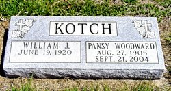
Pansy L “Pat” Woodward Kotch
| Birth | : | 27 Aug 1905 Liberty, Gage County, Nebraska, USA |
| Death | : | 21 Sep 2004 McMinnville, Yamhill County, Oregon, USA |
| Burial | : | God's Little Acre Cemetery, Newport, Newport County, USA |
| Coordinate | : | 41.4965150, -71.3163130 |
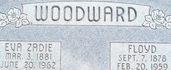
| Description | : | Died in Oakwood Country Place. The daughter of Floyd and Zadie Ackerman Woodward. When she was small, her parents homesteaded near Brush, CO, but moved back to farms in Nebraska when she was about 8. Mrs. Kotch was baptized in the Pleasant Hill Christian Church at an early age and attended the Dayton First Baptist Church since moving to the community in 1971. She and William "Bill" Kotch married Aug. 22, 1951, in Las Vegas. They lived in Ventura and Oakview, CA, until moving to Dayton. She loved flowers, gardening, camping, fishing and traveling, which the Kotchs did often. Survivors... Read More |
frequently asked questions (FAQ):
-
Where is Pansy L “Pat” Woodward Kotch's memorial?
Pansy L “Pat” Woodward Kotch's memorial is located at: God's Little Acre Cemetery, Newport, Newport County, USA.
-
When did Pansy L “Pat” Woodward Kotch death?
Pansy L “Pat” Woodward Kotch death on 21 Sep 2004 in McMinnville, Yamhill County, Oregon, USA
-
Where are the coordinates of the Pansy L “Pat” Woodward Kotch's memorial?
Latitude: 41.4965150
Longitude: -71.3163130
Family Members:
Parent

Spouse
Siblings
Children
Flowers:


Nearby Cemetories:
1. God's Little Acre Cemetery
Newport, Newport County, USA
Coordinate: 41.4965150, -71.3163130
2. Common Burying Ground
Newport, Newport County, USA
Coordinate: 41.4959564, -71.3165741
3. Braman Cemetery
Newport, Newport County, USA
Coordinate: 41.4956360, -71.3169098
4. Willow Cemetery
Newport, Newport County, USA
Coordinate: 41.4949890, -71.3164650
5. North Burial Ground
Newport, Newport County, USA
Coordinate: 41.4981270, -71.3170700
6. Saint Marys Cemetery
Newport, Newport County, USA
Coordinate: 41.4971085, -71.3135147
7. Island Cemetery
Newport, Newport County, USA
Coordinate: 41.4956589, -71.3135605
8. Friends Cemetery
Newport, Newport County, USA
Coordinate: 41.4934807, -71.3136826
9. Coddington Cemetery
Newport, Newport County, USA
Coordinate: 41.4923706, -71.3143616
10. John Clarke Cemetery
Newport, Newport County, USA
Coordinate: 41.4937897, -71.3112869
11. Malboro Street Tomb (Defunct)
Newport, Newport County, USA
Coordinate: 41.4911110, -71.3136110
12. Bliss-Pierce Lot
Newport, Newport County, USA
Coordinate: 41.4941140, -71.3090260
13. Dyre Family Burial Ground (Defunct)
Newport, Newport County, USA
Coordinate: 41.5016070, -71.3209220
14. First Sabbatarian Church of Newport Cemetery
Newport, Newport County, USA
Coordinate: 41.4891701, -71.3116379
15. Barney Street Cemetery
Newport, Newport County, USA
Coordinate: 41.4893608, -71.3109818
16. Goat Island Pirate Graves
Newport, Newport County, USA
Coordinate: 41.4928600, -71.3269300
17. Goat Island Burial Ground
Newport, Newport County, USA
Coordinate: 41.4930330, -71.3272510
18. Trinity Church Cemetery
Newport, Newport County, USA
Coordinate: 41.4874229, -71.3131180
19. Moravian Church Lot
Newport, Newport County, USA
Coordinate: 41.4874190, -71.3113130
20. Colonial Jewish Cemetery of Rhode Island
Newport, Newport County, USA
Coordinate: 41.4879265, -71.3093567
21. First Congregational Churchyard (Defunct)
Newport, Newport County, USA
Coordinate: 41.4864020, -71.3119910
22. Governor Arnold Burying Ground
Newport, Newport County, USA
Coordinate: 41.4861300, -71.3119900
23. Newport Congregational Church Cemetery
Newport, Newport County, USA
Coordinate: 41.4857674, -71.3128662
24. Judge Anthony Wilbur Cemetery
Newport, Newport County, USA
Coordinate: 41.4989600, -71.3018300