
| Birth | : | 17 Mar 1943 La Harpe, Allen County, Kansas, USA |
| Death | : | 9 Feb 2015 Overbrook, Osage County, Kansas, USA |
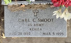
| Burial | : | Vassar Cemetery, Osage County, USA |
| Coordinate | : | 38.6408005, -95.6192017 |
| Description | : | March 17, 1943 – Feb. 9, 2015 OVERBROOK—Paul “Bud” Smoot, Lyndon, died Feb. 9, 2015, at Brookside Retirement Community, Overbrook. He was 71. He was born March 17, 1943, at LaHarpe, the son of Ira and Mary Poe Smoot. He was raised and attended school in LaHarpe. He later moved to Iola and then made his home in Lyndon in 1974. He worked as a custodian for Lyndon USD 421, retiring in 1997. He owned and operated Bud’s Bunny Farm for several years. He had also coached boys summer league baseball in Iola and Lyndon for many years. He married Ila Anderson Nov.... Read More |
frequently asked questions (FAQ):
-
Where is Paul “Bud” Smoot's memorial?
Paul “Bud” Smoot's memorial is located at: Vassar Cemetery, Osage County, USA.
-
When did Paul “Bud” Smoot death?
Paul “Bud” Smoot death on 9 Feb 2015 in Overbrook, Osage County, Kansas, USA
-
Where are the coordinates of the Paul “Bud” Smoot's memorial?
Latitude: 38.6408005
Longitude: -95.6192017
Family Members:
Parent
Spouse

Siblings
Flowers:


Nearby Cemetories:
1. Vassar Cemetery
Osage County, USA
Coordinate: 38.6408005, -95.6192017
2. Lamont Hill Cemetery
Vassar, Osage County, USA
Coordinate: 38.6392400, -95.6004600
3. Salt Creek Cemetery
Osage County, USA
Coordinate: 38.6164100, -95.5875300
4. Mount Zion Cemetery
Vassar, Osage County, USA
Coordinate: 38.6796989, -95.6181030
5. Lyndon Cemetery
Lyndon, Osage County, USA
Coordinate: 38.6225014, -95.7007980
6. Danish Cemetery
Lyndon, Osage County, USA
Coordinate: 38.5723200, -95.6385200
7. Pleasant Ridge Cemetery
Osage County, USA
Coordinate: 38.6492004, -95.5271988
8. Eastview Cemetery
Quenemo, Osage County, USA
Coordinate: 38.6081009, -95.5235977
9. Oak Hill Cemetery
Quenemo, Osage County, USA
Coordinate: 38.5918999, -95.5333023
10. Lyndon Amish Mennonite Cemetery
Melvern, Osage County, USA
Coordinate: 38.5796900, -95.6991800
11. Valley Brook Cemetery
Michigan Valley, Osage County, USA
Coordinate: 38.7242279, -95.5646362
12. Sutton Cemetery
Melvern, Osage County, USA
Coordinate: 38.5430984, -95.6168976
13. Highland Cemetery
Scranton, Osage County, USA
Coordinate: 38.7103004, -95.7099991
14. Humphreys Cemetery
Quenemo, Osage County, USA
Coordinate: 38.5398300, -95.5316200
15. Woodlawn Cemetery
Pomona, Franklin County, USA
Coordinate: 38.6100006, -95.4681015
16. Dean Cemetery
Pomona, Franklin County, USA
Coordinate: 38.7038994, -95.4781036
17. Mount Calvary Catholic Cemetery
Scranton, Osage County, USA
Coordinate: 38.7528000, -95.7055969
18. Melvern Cemetery
Melvern, Osage County, USA
Coordinate: 38.5057983, -95.6549988
19. Pleasant View Cemetery
Melvern, Osage County, USA
Coordinate: 38.5064011, -95.5727997
20. Overbrook Cemetery
Overbrook, Osage County, USA
Coordinate: 38.7751083, -95.5487442
21. Nightingale Farm Cemetery
Pomona, Franklin County, USA
Coordinate: 38.5815300, -95.4409300
22. Borland Cemetery
Osage City, Osage County, USA
Coordinate: 38.7243800, -95.7822400
23. Scranton Cemetery
Scranton, Osage County, USA
Coordinate: 38.7708015, -95.7221985
24. Appanoose Cemetery
Globe, Douglas County, USA
Coordinate: 38.7392006, -95.4642029