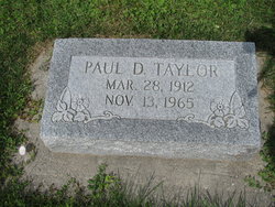
Paul Donald Taylor
| Birth | : | 28 Mar 1912 Ridgeway, Harrison County, Missouri, USA |
| Death | : | 13 Nov 1965 Yellowstone County, Montana, USA |
| Burial | : | Bridger Cemetery, Bridger, Carbon County, USA |
| Coordinate | : | 45.2825012, -108.9244003 |
frequently asked questions (FAQ):
-
Where is Paul Donald Taylor's memorial?
Paul Donald Taylor's memorial is located at: Bridger Cemetery, Bridger, Carbon County, USA.
-
When did Paul Donald Taylor death?
Paul Donald Taylor death on 13 Nov 1965 in Yellowstone County, Montana, USA
-
Where are the coordinates of the Paul Donald Taylor's memorial?
Latitude: 45.2825012
Longitude: -108.9244003
Family Members:
Parent
Spouse
Siblings
Children
Flowers:
Nearby Cemetories:
1. Bridger Cemetery
Bridger, Carbon County, USA
Coordinate: 45.2825012, -108.9244003
2. Mountain View Cemetery
Bridger, Carbon County, USA
Coordinate: 45.2588997, -108.8910980
3. Silver Tip Ranch Cemetery
Bridger, Carbon County, USA
Coordinate: 45.1889340, -108.9850340
4. Teeples Cemetery
Bridger, Carbon County, USA
Coordinate: 45.3248600, -108.7785880
5. Gebo Cemetery
Fromberg, Carbon County, USA
Coordinate: 45.4030000, -108.9242000
6. Beltz Cemetery
Carbon County, USA
Coordinate: 45.4049988, -109.0706024
7. Belfry Cemetery
Belfry, Carbon County, USA
Coordinate: 45.1200570, -109.0106020
8. Roberts Cemetery
Roberts, Carbon County, USA
Coordinate: 45.3605995, -109.1536026
9. Carbonado Cemetery
Joliet, Carbon County, USA
Coordinate: 45.4585991, -109.0139008
10. Clear Creek Cemetery
Roberts, Carbon County, USA
Coordinate: 45.2416992, -109.1931000
11. Bearcreek Cemetery
Bearcreek, Carbon County, USA
Coordinate: 45.1577797, -109.1380615
12. Joliet Cemetery
Joliet, Carbon County, USA
Coordinate: 45.4799995, -108.9985962
13. Bowler Cemetery
Bowler, Carbon County, USA
Coordinate: 45.1492004, -108.7018967
14. Rockvale Cemetery
Rockvale, Carbon County, USA
Coordinate: 45.4888770, -108.8626350
15. Red Lodge Cemetery
Red Lodge, Carbon County, USA
Coordinate: 45.1947200, -109.2605200
16. Sunrise Cemetery
Carbon County, USA
Coordinate: 45.3105450, -109.2888330
17. Chance Mountain View Cemetery
Chance, Carbon County, USA
Coordinate: 45.0447006, -109.0856018
18. John Henry Cemetery
Carbon County, USA
Coordinate: 45.2580986, -109.3031006
19. Tolman Cemetery
Carbon County, USA
Coordinate: 45.0611000, -109.1547012
20. Deuel Castange Cemetery
Red Lodge, Carbon County, USA
Coordinate: 45.3380000, -109.3104370
21. Big Day Cemetery
Pryor, Big Horn County, USA
Coordinate: 45.4169006, -108.5653000
22. Plenty Coups State Park Cemetery
Pryor, Big Horn County, USA
Coordinate: 45.4287870, -108.5491920
23. Sings Good-Stewart Family Cemetery
Pryor, Big Horn County, USA
Coordinate: 45.4076540, -108.5289690
24. Saint Olaf Cemetery
Luther, Carbon County, USA
Coordinate: 45.4064636, -109.3343735


