
| Birth | : | 11 Jul 1932 Wessington, Beadle County, South Dakota, USA |
| Death | : | 3 Jun 1997 Miller, Hand County, South Dakota, USA |
| Burial | : | Cobbs Chapel Cemetery, Hornbeak, Obion County, USA |
| Coordinate | : | 36.3708000, -89.2932968 |
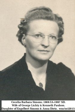
| Description | : | Born on and raised on the family farm at Wessington. Attended country school and high school at Wessington. Married ___ Sept. 12, 1951 at Miller, SD. Paul & __ became the parents of 11 children. Entered the U.S. Army July 24, 1952. Served in Korea as a Medical Corpsman. Discharged on Feb. 8, 1954. Returned to the Wessington area and farmed. Obituary in The Miller Press, Miller, Hand, South Dakota, Wednesday, June 11, 1997, p6 c1&2 courtesy of findagrave contributor Barb Jones. |
frequently asked questions (FAQ):
-
Where is Paul Edwin Lichty's memorial?
Paul Edwin Lichty's memorial is located at: Cobbs Chapel Cemetery, Hornbeak, Obion County, USA.
-
When did Paul Edwin Lichty death?
Paul Edwin Lichty death on 3 Jun 1997 in Miller, Hand County, South Dakota, USA
-
Where are the coordinates of the Paul Edwin Lichty's memorial?
Latitude: 36.3708000
Longitude: -89.2932968
Family Members:
Parent

Spouse
Siblings
Flowers:


Nearby Cemetories:
1. Cobbs Chapel Cemetery
Hornbeak, Obion County, USA
Coordinate: 36.3708000, -89.2932968
2. McElyea Family Cemetery
Hornbeak, Obion County, USA
Coordinate: 36.3812510, -89.2747890
3. Antioch Baptist Cemetery
Hornbeak, Obion County, USA
Coordinate: 36.3462220, -89.3137510
4. Ellison Cemetery
Samburg, Obion County, USA
Coordinate: 36.3991000, -89.3117000
5. Hornbeak City Cemetery
Hornbeak, Obion County, USA
Coordinate: 36.3317410, -89.2898260
6. Graves Chapel Cemetery
Hornbeak, Obion County, USA
Coordinate: 36.3331440, -89.2567170
7. Obion Chapel Cemetery
Hornbeak, Obion County, USA
Coordinate: 36.3320720, -89.2578030
8. Goodman Cemetery
Troy, Obion County, USA
Coordinate: 36.3348270, -89.2498700
9. Star of Bethlehem Cemetery
Troy, Obion County, USA
Coordinate: 36.4234400, -89.2696400
10. Ebenezer Cemetery
Troy, Obion County, USA
Coordinate: 36.3689003, -89.2208023
11. Bethlehem Cemetery
Troy, Obion County, USA
Coordinate: 36.3148900, -89.2173340
12. Canaday Cemetery
Englewood, Obion County, USA
Coordinate: 36.3677150, -89.1890660
13. Mount Moriah Cemetery
Troy, Obion County, USA
Coordinate: 36.3019000, -89.2328000
14. Oak Ridge Church of Christ Cemetery
Elbridge, Obion County, USA
Coordinate: 36.2828550, -89.2959020
15. Mills Cemetery
Mount Moriah, Obion County, USA
Coordinate: 36.2888890, -89.2522220
16. Beard Cemetery
Troy, Obion County, USA
Coordinate: 36.2977982, -89.2300034
17. Hogue Cemetery
Englewood, Obion County, USA
Coordinate: 36.3591995, -89.1808014
18. Oak Ridge Cemetery
Obion County, USA
Coordinate: 36.2783012, -89.3007965
19. Mount Manuel Cemetery
Union City, Obion County, USA
Coordinate: 36.4652270, -89.2992640
20. New Campground Cemetery
Troy, Obion County, USA
Coordinate: 36.3168460, -89.1967820
21. Campground Cemetery
Camp Ground, Obion County, USA
Coordinate: 36.3149800, -89.1960600
22. Crockett Cemetery
Englewood, Obion County, USA
Coordinate: 36.3906800, -89.1745580
23. Terrace Hill Cemetery
Troy, Obion County, USA
Coordinate: 36.3382988, -89.1763992
24. Cloar Cemetery
Clayton, Obion County, USA
Coordinate: 36.4576590, -89.2274410