Paul Frederick Pein
| Birth | : | 17 Apr 1921 Okanogan, Okanogan County, Washington, USA |
| Death | : | 28 Sep 1999 Omak, Okanogan County, Washington, USA |
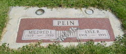
| Burial | : | Sherwood Cemetery, Sherwood, Branch County, USA |
| Coordinate | : | 42.0066660, -85.2386110 |
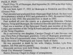
| Description | : | Paul F. Pein, 78, of Okanogan, died September 28, 1999 at the Mid-Valley Hospital in Omak. He was born April 17, 1921 in Okanogan to Frederick and Elva May (Greene) Pein. Paul attended and graduated from Okanogan High School. He then went on to pharmacy school at WSU and graduated in 1943. He married Gladys Duncan in July 1940. She preceded him in death in 1993. Paul worked all over the county as a pharmacist; Brewster, Chelan, Pateros, Twisp and Okanogan. He worked in Oroville until three weeks ago. Paul was a member of the Twisp Kiwanis and past member and president of the... Read More |
frequently asked questions (FAQ):
-
Where is Paul Frederick Pein's memorial?
Paul Frederick Pein's memorial is located at: Sherwood Cemetery, Sherwood, Branch County, USA.
-
When did Paul Frederick Pein death?
Paul Frederick Pein death on 28 Sep 1999 in Omak, Okanogan County, Washington, USA
-
Where are the coordinates of the Paul Frederick Pein's memorial?
Latitude: 42.0066660
Longitude: -85.2386110
Family Members:
Parent
Spouse
Siblings
Flowers:
Nearby Cemetories:
1. Sherwood Cemetery
Sherwood, Branch County, USA
Coordinate: 42.0066660, -85.2386110
2. Blossom Road Cemetery
Sherwood Township, Branch County, USA
Coordinate: 42.0160380, -85.2737760
3. North Sherwood Cemetery
Sherwood, Branch County, USA
Coordinate: 42.0611000, -85.2481003
4. Banta Cemetery
Leonidas, St. Joseph County, USA
Coordinate: 41.9922220, -85.3125000
5. Factoryville Cemetery
Factoryville, St. Joseph County, USA
Coordinate: 42.0505560, -85.3069460
6. Matteson Cemetery
Matteson, Branch County, USA
Coordinate: 41.9406013, -85.2046967
7. Burr Oak Cemetery
Athens, Calhoun County, USA
Coordinate: 42.0844002, -85.2461014
8. Colon United Methodist Church Columbarium
Colon, St. Joseph County, USA
Coordinate: 41.9598940, -85.3245500
9. McAuley Cemetery
Leonidas Township, St. Joseph County, USA
Coordinate: 41.9916992, -85.3450012
10. Lakeside Cemetery
Colon, St. Joseph County, USA
Coordinate: 41.9667015, -85.3364029
11. Old Burg Cemetery
Athens, Calhoun County, USA
Coordinate: 42.0916660, -85.2208330
12. Covey Road Amish Cemetery
Leonidas, St. Joseph County, USA
Coordinate: 41.9990290, -85.3613490
13. Riverside Cemetery
Union City, Branch County, USA
Coordinate: 42.0734200, -85.1351700
14. South Colon Cemetery
Colon, St. Joseph County, USA
Coordinate: 41.9199982, -85.3114014
15. Indian Cemetery
Athens, Calhoun County, USA
Coordinate: 42.1126140, -85.2647750
16. Leonidas Cemetery
Leonidas, St. Joseph County, USA
Coordinate: 42.0330000, -85.4100000
17. Walker Cemetery
Athens, Calhoun County, USA
Coordinate: 42.1352770, -85.2119440
18. Beard Cemetery
Leonidas, St. Joseph County, USA
Coordinate: 42.0711090, -85.3916700
19. Stimpson Cemetery
Athens, Calhoun County, USA
Coordinate: 42.1380000, -85.2520000
20. York Cemetery
Batavia, Branch County, USA
Coordinate: 41.9009350, -85.1318550
21. South Fulton Cemetery
Fulton, Kalamazoo County, USA
Coordinate: 42.1119610, -85.3524830
22. Sprung Cemetery
Mendon, St. Joseph County, USA
Coordinate: 42.0213889, -85.4194444
23. Batavia Cemetery
Batavia, Branch County, USA
Coordinate: 41.9202778, -85.0975000
24. Tripp Cemetery
Batavia, Branch County, USA
Coordinate: 41.9425000, -85.0694440


