
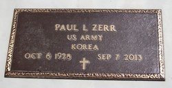
Paul L. Zerr
| Birth | : | 6 Oct 1928 Park, Gove County, Kansas, USA |
| Death | : | 7 Sep 2013 Colby, Thomas County, Kansas, USA |
| Burial | : | Sacred Heart Cemetery, Park, Gove County, USA |
| Coordinate | : | 39.1147003, -100.3555984 |
| Description | : | ` Paul L. Zerr, 84, Colby, formerly of Park, died Saturday, Sept. 7, 2013, at Citizens Medical Center, Colby. He was born Oct. 6, 1928, in Park to James M. and Martha C. (Depperschmidt) Zerr. He attended a one-room school called West Sunny Slope in rural Gove County. He worked for a landscape company, helping landscape many rest stops along Interstate 70 in western Kansas. He was a U.S. Army veteran, serving during the Korean War. Survivors include a brother, Arthur Zerr, Thornton, Colo.; and five sisters, Adalaid Kruse, Colby, Henrietta Jackson, Pamona, Colo., Julia Robben and... Read More |
frequently asked questions (FAQ):
-
Where is Paul L. Zerr's memorial?
Paul L. Zerr's memorial is located at: Sacred Heart Cemetery, Park, Gove County, USA.
-
When did Paul L. Zerr death?
Paul L. Zerr death on 7 Sep 2013 in Colby, Thomas County, Kansas, USA
-
Where are the coordinates of the Paul L. Zerr's memorial?
Latitude: 39.1147003
Longitude: -100.3555984
Family Members:
Parent

Siblings
Flowers:


Nearby Cemetories:
1. Sacred Heart Cemetery
Park, Gove County, USA
Coordinate: 39.1147003, -100.3555984
2. West Park Cemetery
Gove County, USA
Coordinate: 39.1107100, -100.3688300
3. Grainfield Cemetery
Grainfield, Gove County, USA
Coordinate: 39.1180992, -100.4708023
4. Quinter Cemetery
Quinter, Gove County, USA
Coordinate: 39.0736008, -100.2236023
5. Old Order German Baptist Cemetery
Quinter, Gove County, USA
Coordinate: 39.0299988, -100.2052994
6. Bethel Christian Cemetery
Studley, Sheridan County, USA
Coordinate: 39.2334100, -100.2051300
7. Red Top Cemetery
Quinter, Gove County, USA
Coordinate: 38.9449997, -100.2431030
8. Gove Cemetery
Gove, Gove County, USA
Coordinate: 38.9467010, -100.4847031
9. Saint Michaels Cemetery
Collyer, Trego County, USA
Coordinate: 39.0318985, -100.1153030
10. Mount Pleasant Community Cemetery
Studley, Sheridan County, USA
Coordinate: 39.2550011, -100.1635971
11. Union Cemetery
Collyer, Trego County, USA
Coordinate: 39.0299988, -100.1125031
12. Immaculate Conception Cemetery
Grinnell, Gove County, USA
Coordinate: 39.1282997, -100.6316986
13. Grinnell Cemetery
Grinnell, Gove County, USA
Coordinate: 39.1300011, -100.6352997
14. Baugher Cemetery
Studley, Sheridan County, USA
Coordinate: 39.3205600, -100.2560800
15. Gove County Cemetery
Gove Township, Gove County, USA
Coordinate: 38.9376127, -100.5277188
16. Saint Anthony Cemetery
Graham County, USA
Coordinate: 39.1892014, -100.0805969
17. Saint Frances Cemetery
Hoxie, Sheridan County, USA
Coordinate: 39.3541985, -100.4597015
18. Saint Pauls Catholic Cemetery
Angelus, Sheridan County, USA
Coordinate: 39.1912810, -100.6854250
19. Hoxie Cemetery
Hoxie, Sheridan County, USA
Coordinate: 39.3736000, -100.4421997
20. Morning Star Cemetery
Gove County, USA
Coordinate: 38.8431015, -100.3349991
21. Studley Cemetery
Studley, Sheridan County, USA
Coordinate: 39.3568993, -100.1631012
22. Leland Cemetery
Penokee, Graham County, USA
Coordinate: 39.2256012, -100.0149994
23. Saint Martins Cemetery
Seguin, Sheridan County, USA
Coordinate: 39.3396988, -100.5907974
24. Saline Valley Cemetery
Trego County, USA
Coordinate: 39.1180992, -99.9610977