
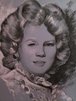


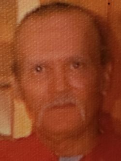
Paula Lanette Frasier Christopher
| Birth | : | 27 Feb 1964 Anderson County, South Carolina, USA |
| Death | : | 9 Aug 2006 Anderson County, South Carolina, USA |
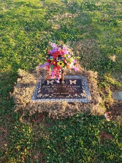
| Burial | : | Holy Family Cemetery, Lindsay, Platte County, USA |
| Coordinate | : | 41.6921997, -97.6832962 |
| Description | : | Daughter of Paul Frasier and Judy Williams Wife of Bill Christopher Mother of William Brandon Christopher |
frequently asked questions (FAQ):
-
Where is Paula Lanette Frasier Christopher's memorial?
Paula Lanette Frasier Christopher's memorial is located at: Holy Family Cemetery, Lindsay, Platte County, USA.
-
When did Paula Lanette Frasier Christopher death?
Paula Lanette Frasier Christopher death on 9 Aug 2006 in Anderson County, South Carolina, USA
-
Where are the coordinates of the Paula Lanette Frasier Christopher's memorial?
Latitude: 41.6921997
Longitude: -97.6832962
Family Members:
Parent
Spouse

Flowers:


Nearby Cemetories:
1. Holy Family Cemetery
Lindsay, Platte County, USA
Coordinate: 41.6921997, -97.6832962
2. Saint Bernard Cemetery
Lindsay, Platte County, USA
Coordinate: 41.7155991, -97.6286011
3. Saint Pauls Lutheran Cemetery
Platte County, USA
Coordinate: 41.7425003, -97.6286011
4. Looking Glass Cemetery
Rosenborg, Platte County, USA
Coordinate: 41.6571000, -97.7617000
5. Evangelical Cemetery
Madison County, USA
Coordinate: 41.7625008, -97.6772003
6. Bethany Lutheran Cemetery
Platte County, USA
Coordinate: 41.6232700, -97.7177200
7. Saint Johns Catholic Cemetery
Lindsay, Platte County, USA
Coordinate: 41.6293500, -97.6282500
8. Saint Ansgar Cemetery
Rosenborg, Platte County, USA
Coordinate: 41.6334000, -97.7539000
9. Hope Cemetery
Platte County, USA
Coordinate: 41.7383003, -97.7742004
10. Sacred Heart Cemetery
Cornlea, Platte County, USA
Coordinate: 41.6808014, -97.5708008
11. Palestine Cemetery
Rosenborg, Platte County, USA
Coordinate: 41.5980000, -97.7057000
12. Granville Cemetery
Cornlea, Platte County, USA
Coordinate: 41.6712450, -97.5542160
13. Kalamazoo Cemetery
Madison County, USA
Coordinate: 41.7787000, -97.6195000
14. Shell Creek Lutheran Cemetery
Newman Grove, Madison County, USA
Coordinate: 41.7717018, -97.7652969
15. Salem Lutheran Cemetery
Woodville Township, Platte County, USA
Coordinate: 41.6525800, -97.8084000
16. Postville Cemetery
Platte County, USA
Coordinate: 41.5924644, -97.6203079
17. Trinity Cemetery
Newman Grove, Madison County, USA
Coordinate: 41.7574997, -97.8035965
18. Moriah Cemetery
Platte County, USA
Coordinate: 41.6268997, -97.5622025
19. Burrows Cemetery
Platte County, USA
Coordinate: 41.5983009, -97.5813980
20. Saint Paul Evangelical Lutheran Cemetery
Monroe, Platte County, USA
Coordinate: 41.5651140, -97.6740360
21. Zion Evangelical Cemetery
Madison, Madison County, USA
Coordinate: 41.8010000, -97.5793000
22. Iowa Valley Cemetery
Madison County, USA
Coordinate: 41.8292007, -97.6588974
23. West Hill Cemetery
Platte County, USA
Coordinate: 41.5558014, -97.7161026
24. Green Garden Cemetery
Madison County, USA
Coordinate: 41.8100014, -97.5796967